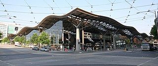
Harbour Esplanade

Last updated

Harbour Esplanade

Harbour Esplanade, Docklands.jpg
Harbour Esplanade facing south opposite Victoria Dock
Harbour Esplanade
Australia Victoria metropolitan Melbourne location map.svg
Red pog.svg
Harbour Esplanade
Coordinates
General information
TypeStreet
Length2.5 km (1.6 mi)
Opened2007
Major junctions
North endAustralian state route 32.svg Footscray Road
West Melbourne
 
South endNavigation Drive
Docklands, Melbourne
Location(s)
LGA(s) City of Melbourne
Suburb(s) Docklands

Harbour Esplanade is a waterfront street and thoroughfare in Docklands, an inner suburb of Melbourne, Victoria, Australia. It runs roughly north-south from Navigation Drive in the south to Docklands Drive in the north. The road also forms the eastern boundary of the Victoria Harbour inlet and is adjacent to Victoria Dock.

Contents

The esplanade is a core element of the Docklands urban renewal precinct and is known for housing Docklands Stadium and several converted dock buildings that now serve as pubs and function spaces. Harbour Esplanade is also the location of office buildings and restaurants, whilst the Capital City Trail runs parallel along some of its length.

It has been described as Melbourne's waterfront boulevard and its future potential is compared to the successful Circular Quay in Sydney. [1]

History

Harbour Esplanade facing south from Docklands Stadium Terrace, 2009 Mlb docklands from etihad.jpg
Harbour Esplanade facing south from Docklands Stadium Terrace, 2009

Harbour Esplanade was previously known as Footscray Road - between Dudley Street and Pigott Street (now renamed Bourke Street) - and Charles Grimes Bridge Road, connecting West Melbourne through the Docklands precinct over the Yarra River to South Melbourne, without needing to go through central Melbourne. The road was dual-carriageway through a mainly freight and heavy industrial area that had fallen into dis-use by the mid-1980s. With the transformation of Harbour Esplanade as a dock-side boulevard, Wurundjeri Way was built as a replacement through route in 1999.

Creation

Harbour Esplanade was gazetted as part of the Docklands urban renewal project in 2007. [2] Initially a somewhat disconnected street with minimal attractions and accessibility, the area is now the focus of further development and government grants to help improve the amenity of the Docklands area. [3]

In response to criticisms regarding lack of green space, Norfolk Island Pine trees were planted along the length of the esplanade in 2011, in addition to the creation of dedicated bike lane and pedestrian pathway. [4] Tram tracks were also realigned and the vision for Harbour Esplanade to connect the Yarra River to Victoria Harbour in a more complete way was realised. [4]

Places Victoria has also funded the construction of Hortus, a glasshouse with an edible plant installation, café and outdoor environment to bring further life to the area. [3]

Criticism

In 2010, Places Victoria's general manager David Young acknowledged that Harbour Esplanade "doesn't stack up". Kim Dovey, professor of architecture and design at the University of Melbourne stated that Harbour Esplanade was "too big" for the Docklands precinct. [4] The Lord Mayor has also criticised initial planning for the esplanade, claiming it should have been the first thing considered when planning Docklands. [1]

Future

A view to Victoria Harbour Promenade from Docklands Stadium Docklands , Melbourne.jpg
A view to Victoria Harbour Promenade from Docklands Stadium

Proposals have been submitted to improve the Victoria Harbour precinct, with a focus on Harbour Esplanade as the main thoroughfare. Proposals include water taxis, a ferry terminal, opera performances and a function room along the esplanade offering waterside views. [1] [5] Lord Mayor of Melbourne Robert Doyle described his vision for the precinct as "a range of complementary uses and buildings... on Harbour Esplanade, not just this big wide expanse". [1] Addition proposals have been put forward to dock heritage vessels such as the Alma Doepel and the Enterprize in Victoria Harbour. [6] [3]

Notable buildings

Docklands Stadium and Harbour Esplanade from Victoria Dock Docklands Stadium (Etihad Stadium) 2014.jpg
Docklands Stadium and Harbour Esplanade from Victoria Dock

Several buildings and structures along Harbour Esplanade are listed on the Victorian Heritage Register and/or classified by the National Trust of Australia, including:

In addition, there are several newer landmarks:

Transport

Harbour esplanade is serviced by the City Circle tram in addition to tram route 70 and route 75. [10]

Future plans also include the creation of a Ferry Terminal via Victoria Harbour. [6]

Related Research Articles

<span class="mw-page-title-main">City of Banyule</span> Local government area in Victoria, Australia

The City of Banyule is a local government area in Victoria, Australia in the north-eastern suburbs of Melbourne. It was created under the Local Government Act 1989 and established in 1994 as an amalgamation of former councils. It has an area of 63 square kilometres (24.3 sq mi) and lies between 7 and 21 km from central Melbourne. In 1994 it had a population of 116,000. In June 2018 Banyule had a population of 130,237. The Yarra River runs along the City's southern border while its western border is defined by Darebin Creek.

<span class="mw-page-title-main">Docklands, Victoria</span> Suburb of Melbourne, Victoria, Australia

Docklands, also known as Melbourne Docklands, is an inner-city suburb in Melbourne, Victoria, Australia, 2 km (1.2 mi) west of Melbourne's Central Business District, located within the City of Melbourne local government area. Docklands recorded a population of 15,495 at the 2021 census.

<span class="mw-page-title-main">City Circle tram</span> Tram route in metropolitan Melbourne, Victoria, Australia

The City Circle is a zero-fare tram running around the Melbourne central business district in Australia. Aimed mainly at tourists, the route passes many Melbourne attractions while running along the city centre's outermost thoroughfares, as well as the developing Docklands waterfront precinct. It operates in both clockwise and anti-clockwise direction.

<span class="mw-page-title-main">Heidelberg, Victoria</span> Suburb of Melbourne, Victoria, Australia

Heidelberg is a suburb of Melbourne, Victoria, Australia, 11 kilometres (7 mi) northeast of Melbourne's central business district, located within the City of Banyule local government area. Heidelberg recorded a population of 7,360 at the 2021 census.

<span class="mw-page-title-main">Parliament railway station</span> Railway station in Melbourne, Victoria, Australia

Parliament railway station is an underground railway station in Melbourne, Australia. It is one of three underground stations on the City Loop, which serves the Melbourne CBD. In 2017/2018 it was the fourth-busiest station on Melbourne's metropolitan network, with 10.19 million passenger movements.

<span class="mw-page-title-main">Elizabeth Street, Melbourne</span> Road in Melbourne, Victoria

Elizabeth Street is one of the main streets in the central business district of Melbourne, Victoria, Australia, part of the Hoddle Grid laid out in 1837. It is presumed to have been named in honour of governor Richard Bourke's wife.
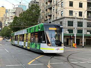
<span class="mw-page-title-main">South Geelong, Victoria</span> Suburb of Geelong, Victoria, Australia

South Geelong, also referred to as Geelong South, is a southern suburb of Geelong, Victoria, Australia. Its local government area is the City of Greater Geelong. At the 2016 census, South Geelong had a population of 993.

<span class="mw-page-title-main">La Trobe Street</span> Street in Melbourne, Victoria

La Trobe Street is a major street and thoroughfare in the city centre of Melbourne, Victoria, Australia. It runs roughly east–west and forms the northern boundary of Melbourne's central business district. The street was laid out as an extension of the original Hoddle Grid in 1839 and was named after Charles La Trobe. La Trobe Street extends from Victoria Street in the east to Harbour Esplanade in the west.

<span class="mw-page-title-main">Victoria Street, Melbourne</span> Road in Melbourne, Victoria

Victoria Street is one of the major thoroughfares of inner Melbourne, running east–west for over six kilometres between Munster Terrace in North Melbourne and the Yarra River. The road is known as Victoria Parade for over one-and-a-half kilometres of its length, distinguishable with a wide reservation and tramway down the middle.

<span class="mw-page-title-main">Melbourne tram route 86</span> Tram route in Melbourne, Victoria, Australia

Melbourne tram route 86 is operated by Yarra Trams on the Melbourne tram network from Bundoora RMIT to Waterfront City. The 22.2-kilometre (13.8 mi) route is operated out of Preston depot with E class trams.

<span class="mw-page-title-main">Melbourne tram route 30</span> Tram route in Melbourne, Victoria, Australia

Melbourne tram route 30 is operated by Yarra Trams on the Melbourne tram network from St Vincent's Plaza to Central Pier. The 2.9-kilometre (1.8 mi) route is operated out of Southbank depot with A and E class trams.

<span class="mw-page-title-main">Melbourne tram route 48</span>

Melbourne tram route 48 is operated by Yarra Trams on the Melbourne tram network from Balwyn North to Victoria Harbour. The 13.5-kilometre (8.4 mi) route is operated out of Kew depot with A and C class trams.

<span class="mw-page-title-main">Bank Place</span> Street in Melbourne, Victoria

Bank Place is a street in Melbourne, Australia. It is a laneway running roughly north-south between Collins Street and Little Collins Street in the central business district.

<span class="mw-page-title-main">Queens Bridge (Melbourne)</span> Bridge in Melbourne, Australia

The Queen's Bridge is a historic road bridge over the Yarra River in Melbourne, Victoria, Australia. The bridge was built in 1889 and has five wrought iron plate girder spans, and is listed on the Victorian Heritage Register. The bridge was built by contractor David Munro, and replaced a timber footbridge built in 1860.

<span class="mw-page-title-main">Charles Grimes Bridge</span> Bridge in Melbourne, Australia

The Charles Grimes Bridge is a dual-carriageway bridge that carries the Docklands Highway over the Yarra River in the Docklands precinct of Melbourne, Australia. It was named after New South Wales surveyor general Charles Grimes, who was the first European to see the Yarra River.

<span class="mw-page-title-main">John Beswicke</span> Architect (1847–1925)

John Beswicke (1847–1925) was an architect who practiced in Melbourne between the 1870s and 1915.

Numerous proposals have been made for improvements to the Melbourne tram network, the largest such network in the world. Nearly all of these have been for track extensions of existing lines to connect with nearby railway station or to service new areas and suburbs.

<span class="mw-page-title-main">East Preston tram depot</span>

East Preston tram depot was a depot on the Yarra Trams network in Melbourne. Located on Plenty Road, East Preston, it opened in 1955 to coincide with the reintroduction of trams to Bourke Street. It closed in April 2016.

<span class="mw-page-title-main">Johnston Street Bridge</span> Bridge across the Yarra River in Melbourne, Australia

Johnston Street Bridge is a concrete road bridge crossing the Yarra River between the Melbourne suburbs of Abbotsford and Kew.

Oakden, Addison and Kemp was an Australian architectural firm in Melbourne, Victoria. While it was short lived, existing from only 1887 to 1892, they designed a number of outstanding projects, and all three members designed many more notable projects in earlier and later partnerships.

References

  1. 1 2 3 4 "Vibrant esplanade to play key Docklands role". Herald Sun . Retrieved 31 January 2017.
  2. Government of Victoria (28 June 2007). "Victoria Government Gazette" (PDF). Victorian Government Printer. Retrieved 31 January 2017.
  3. 1 2 3 "Harbour Esplanade – Places Victoria". places.vic.gov.au. Retrieved 31 January 2017.
  4. 1 2 3 Cooke, Dewi (16 March 2010). "Docklands $9bn plan for next decade". The Age. Retrieved 31 January 2017.
  5. "New plan to boost Docklands" . Retrieved 31 January 2017.
  6. 1 2 "Participate Melbourne :: Harbour Esplanade Engagement". participate.melbourne.vic.gov.au. Retrieved 31 January 2017.
  7. "VHD". vhd.heritagecouncil.vic.gov.au. Retrieved 31 January 2017.
  8. "VHD". vhd.heritagecouncil.vic.gov.au. Retrieved 31 January 2017.
  9. "VHD". vhd.heritagecouncil.vic.gov.au. Retrieved 31 January 2017.
  10. "D3-Bourke St/Harbour Esp (Docklands) – Public Transport Victoria". ptv.vic.gov.au. Archived from the original on 8 March 2016. Retrieved 31 January 2017.