
The Yarra River or historically, the Yarra Yarra River, is a perennial river in south-central Victoria, Australia.

Fairfield is a suburb in Melbourne, Victoria, Australia, 6 km (3.7 mi) north-east of Melbourne's Central Business District, located within the Cities of Darebin and Yarra local government areas. Fairfield recorded a population of 6,535 at the 2021 census.

Alphington is a suburb in Melbourne, Victoria, Australia, 7 km (4.3 mi) north-east of Melbourne's Central Business District, located within the Cities of Darebin and Yarra local government areas. Alphington recorded a population of 5,702 at the 2021 census.

Northcote is an inner-city suburb in Melbourne, Victoria, Australia, 7 km (4.3 mi) north-east of Melbourne's Central Business District, located within the City of Darebin local government area. Northcote recorded a population of 25,276 at the 2021 census.

Darebin railway station is located on the Hurstbridge line in Victoria, Australia. It serves the north-eastern Melbourne suburb of Ivanhoe, and opened on 8 May 1922.

The Hurstbridge line is a commuter railway line in the city of Melbourne, Victoria, Australia. Operated by Metro Trains Melbourne, it is the city's seventh longest metropolitan railway line at 36.7 kilometres (22.8 mi). The line runs from Flinders Street station in central Melbourne to Hurstbridge station in the north-east, serving 28 stations via Clifton Hill, Heidelberg, Greensborough, and Diamond Creek. The line operates for approximately 19 hours a day with 24 hour service available on Friday and Saturday nights. During peak hour, headways of up to 15 minutes are operated with services every 20-30 minutes during off-peak hours. Trains on the Hurstbridge line run with a two three-car formations of X'Trapolis 100 trainsets.

The Barwon River is a perennial river of the Corangamite catchment, located in The Otways and the Bellarine Peninsula regions of the Australian state of Victoria.

The West Gate Freeway is a major freeway in Melbourne, the busiest urban freeway and the busiest road in Australia, carrying upwards of 200,000 vehicles per day. It links Geelong and Melbourne's western suburbs to central Melbourne and beyond. It is also a link between Melbourne and the west and linking industrial and residential areas west of the Yarra River with the city and port areas. The West Gate Bridge is a part of the freeway.

The Merri Creek Trail is a shared use path for cyclists and pedestrians that follows the Merri Creek through the northern suburbs of Melbourne, Victoria, Australia.

Princes Bridge, originally Prince's Bridge, is a bridge in central Melbourne, Australia that spans the Yarra River. It is built on the site of one of the oldest river crossings in the city, and forms a gateway into the central city from the south. The bridge connects Swanston Street on the north bank of the Yarra River to St Kilda Road on the south bank, and carries road, tram and pedestrian traffic. The present bridge was built in 1888 and is listed on the Victorian Heritage Register.

David Lennox was a Scottish-Australian bridge builder and master stonemason born in Ayr, Scotland.

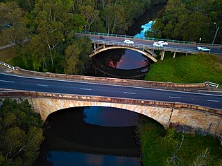
The Chandler Highway is a short road in the inner eastern suburbs of Melbourne. It runs from Heidelberg Road in Alphington, crosses the Yarra River, then continues across the Eastern Freeway, then terminates at an intersection with Princess Street and Earl Street. Its total length is less than 2 kilometres, leading to the claim that it is "the shortest highway in the world". It was named after a prominent local businessman and politician A. E. Chandler, who was instrumental in pushing through the development of the Outer Circle railway.

Bellfield is a suburb of Melbourne, Victoria, Australia, 9 km north-east from Melbourne's Central Business District, located within the City of Banyule local government area. Bellfield recorded a population of 1,996 at the 2021 census.

The Darebin Creek Trail is a shared use path for cyclists and pedestrians which follows Darebin Creek in the inner and outer northern suburbs of Melbourne, Victoria, Australia.
John Campbell Climie (1828–1916) was a Scottish-born engineer who worked in Australia and New Zealand. He may have been working in Melbourne as early as 1856, when Austin, Climie & Co called for tenders for erecting a dwelling house for A. Grant at 193 Lonsdale St East, while he was resident in Caulfield near Melbourne by 1859.

The Perkiomen Bridge, originally built 1798-99 and widened in 1928, is one of the oldest stone arch bridges in the United States still in use. It crosses Perkiomen Creek near Collegeville, Pennsylvania. The bridge's six semi-circular arches cover a total of over 300 feet (91 m). The longest arch spans 76 feet (23 m). Its decorative piers and belts courses are unusual for a bridge this old. A lottery financed $20,000 of the original construction. The bridge carried the main road from Philadelphia to Reading, known at various times as the Manatawny Pike, Germantown Pike, the Philadelphia-Reading Pike, and US 422. Since the construction of the US 422 bypass, the road has been known as Ridge Pike or Old US 422.

The Hawthorn Railway Bridge is a steel truss bridge that crosses the Yarra River 5 kilometres (3.1 mi) east of Melbourne between Burnley and Hawthorn stations on the Alamein, Belgrave and Lilydale railway lines. It was built for the Melbourne and Suburban Railway Company and is the oldest extant railway bridge over the Yarra River.
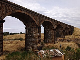
The Malmsbury Viaduct is a large brick and stone masonry arch bridge over the Coliban River at Malmsbury on the Bendigo Railway in Victoria Australia. It was erected as part of the Melbourne, Mount Alexander and Murray River Railway between 1858 and 1861, and was at the time the largest masonry arch railway bridge built in Victoria.
The Lansdowne Bridge is a heritage-listed road bridge that carries the northbound carriageway of the Hume Highway across Prospect Creek between Lansvale and Lansdowne. Situated in southwestern Sydney it is located on the boundary of the Fairfield and Canterbury-Bankstown local government areas. The bridge was named in honour of Henry Petty-Fitzmaurice, 3rd Marquess of Lansdowne (1780-1863), an Irish Whig politician of the British Parliament and associate of the NSW Governor of the day, Sir Richard Bourke.
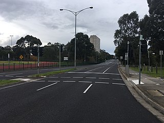
Heidelberg Road is a major arterial road through the north-eastern suburbs of Melbourne. It was the first road in Victoria outside the township of Melbourne. Heidelberg Road was the main route for people travelling to Heidelberg, from the mid to late 1800s.

