
A swing bridge is a movable bridge that has as its primary structural support a vertical locating pin and support ring, usually at or near to its center of gravity, about which the turning span can then pivot horizontally as shown in the animated illustration to the right. Small swing bridges as found over canals may be pivoted only at one end, opening as would a gate, but require substantial underground structure to support the pivot.

A bascule bridge is a moveable bridge with a counterweight that continuously balances a span, or leaf, throughout its upward swing to provide clearance for boat traffic. It may be single- or double-leafed.

The Main North Line is a major railway in New South Wales, Australia. It runs through the Central Coast, Hunter and New England regions. The line was the original main line between Sydney and Brisbane, however this required a change of gauge at Wallangarra. As of 1988, the line closed progressively north of Armidale with services gradually withdrawn till 2004, with the main route between Sydney and Brisbane now the North Coast line.

The Port River is part of a tidal estuary located north of the Adelaide city centre in the Australian state of South Australia. It has been used as a shipping channel since the beginning of European settlement of South Australia in 1836, when Colonel Light selected the site to use as a port. Before colonisation, the Port River region and the estuary area were known as Yerta Bulti by the Kaurna people, and used extensively as a source of food and plant materials to fashion artefacts used in daily life.

Snowtown is a town located in the Mid North of South Australia 145 km north of Adelaide and lies on the main road and rail routes between Adelaide and Perth – the Augusta Highway and Adelaide-Port Augusta railway line. The town's elevation is 103 metres and on average the town receives 389 mm of rainfall per annum.

Australians generally assumed in the 1850s that railways would be built by the private sector. Private companies built railways in the then colonies of Victoria, opened in 1854, and New South Wales, where the company was taken over by the government before completion in 1855, due to bankruptcy. South Australia's railways were government owned from the beginning, including a horse-drawn line opened in 1854 and a steam-powered line opened in 1856. In Victoria, the private railways were soon found not to be financially viable, and existing rail networks and their expansion was taken over by the colony. Government ownership also enabled railways to be built to promote development, even if not apparently viable in strictly financial terms. The railway systems spread from the colonial capitals, except in cases where geography dictated a choice of an alternate port.

The first railway in colonial South Australia was a horse-drawn tramway from the port of Goolwa on the Murray River to an ocean harbour at Port Elliot in 1854. Today the state has 1,600 mm broad gauge suburban railways in Adelaide, a number of country freight lines, as well as key 1,435 mm standard gauge links to other states.
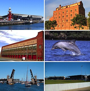
Port Adelaide is a port-side region of Adelaide, approximately 14 kilometres (8.7 mi) northwest of the Adelaide CBD. It is also the namesake of the City of Port Adelaide Enfield council, a suburb, a federal and state electoral division and is the main port for the city of Adelaide. Port Adelaide played an important role in the formative decades of Adelaide and South Australia, with the port being early Adelaide's main supply and information link to the rest of the world. Its Kaurna name, although not officially adopted as a dual name, is Yartapuulti.

The Bridgewater Bridge is a road and rail bridge that carries the Midland Highway and South Railway Line across the Derwent River in Hobart, Tasmania, Australia. The steel truss vertical lift bridge and specially-built causeway connect the Hobart suburbs of Bridgewater and Granton. The bridge was completed in 1946 and accommodates a two-lane highway, a single track railway and a grade-separated footpath.

Alberton railway station is located on the Outer Harbor line. Situated in the north-western Adelaide suburb of Alberton, it is 10.2 kilometres from Adelaide station. The station is registered as a South Australian Heritage.
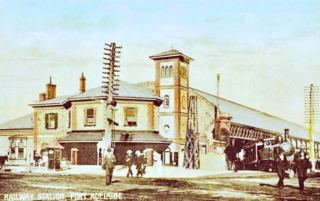
Port Dock railway station – named Port Adelaide until 1916 – was located in the commercial centre of Port Adelaide, South Australia at the corner of St Vincent Street and Lipson Street. It was the original terminus of the railway between Adelaide and Port Adelaide, which opened in 1856.

The Dry Creek–Port Adelaide railway line is an eight-kilometre east–west line running through Adelaide's north-western suburbs. The line is managed by the Australian Rail Track Corporation (ARTC) and is an important link between Port Adelaide, Pelican Point and the main interstate rail routes which link Adelaide with Melbourne, Perth, Darwin and Sydney. Prior to 1988, a limited local passenger service operated, stopping at five intermediate stations along the line. Since May 1988, the line has been freight-only.

Princes Bridge, originally Prince's Bridge, is a bridge in central Melbourne, Australia that spans the Yarra River. It is built on the site of one of the oldest river crossings in the city, and forms a gateway into the central city from the south. The bridge connects Swanston Street on the north bank of the Yarra River to St Kilda Road on the south bank, and carries road, tram and pedestrian traffic. The present bridge was built in 1888 and is listed on the Victorian Heritage Register.

The Sydney Freight Network is a network of dedicated railway lines for freight in Sydney, Australia linking the state's rural and interstate rail network with the city's main yard at Enfield and Port Botany. Its primary components are the Southern Sydney Freight Line (SSFL) and a line from Sefton to Enfield and Port Botany. The Network has been managed by the Australian Rail Track Corporation (ARTC) since 2012. Prior to the completion of the SSFL, it was managed by RailCorp as the Metropolitan Freight Network.
The Hawkesbury River railway bridge is a heritage-listed railway bridge in New South Wales, Australia that carries the Main North railway line across the Hawkesbury River. It is located just north of the town of Brooklyn on the northern outskirts of Sydney. The railway bridge was to be the last link in a railway network that linked the state capitals Adelaide, Melbourne, Sydney and Brisbane and was a major engineering feat at the time. The original railway bridge was built in 1889 and replaced by the current bridge in 1946. The 1946 bridge was added to the New South Wales State Heritage Register on 2 April 1999.
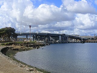
The Tom 'Diver' Derrick Bridge, commonly referred to as the 'Diver' Derrick Bridge, is an opening single-leaf bascule road bridge over the Port River, Port Adelaide, in South Australia. It opened on 1 August 2008. It is located between Docks 1 and 2 at Port Adelaide and links to Francis Street to the east and Victoria Road to the west.

Fort Glanville Conservation Park is a protected area located in the Australian state of South Australia located in Semaphore Park, a seaside suburb of Adelaide consisting of a functional 19th century fort listed on the South Australian Heritage Register and some adjoining land used as a caravan park. The fort was built after more than 40 years of indecision over the defence of South Australia. It was the first colonial fortification in the state and is the best preserved and most functional in Australia. Fort Glanville was designed by Governor Major General Sir William Jervois and Lieutenant Colonel Peter Scratchley, both important figures in early Australian colonial defence. When built it was designed to defend both Semaphore's anchorage and shipping entering the Port River from naval attack.
Westwood, Baillie and Co was a Victorian engineering and shipbuilding company based at London Yard in Cubitt Town, London.
The Milang railway line was a branch line, now closed, of the former South Australian Railways that left the mainline to Victor Harbor at the farming locality of Sandergrove, 9 km (6 mi) south of Strathalbyn and 89.7 km (55.75 mi) by rail from Adelaide. From there it proceeded in a south-easterly direction for 13.1 km (8.1 mi) to the riverport of Milang on Lake Alexandrina, in the estuary of the River Murray. The line was opened on 17 December 1884; it was formally closed on 17 June 1970. The route is now a "rail trail" that is popular with hikers. The precincts of the former Milang station house a railway museum that includes an innovative locomotive driving simulator for visitors to operate. Onsite is a centre for South Australian historical light railways.

Hammond is a town and locality in the Australian state of South Australia located in the southern Flinders Ranges.
