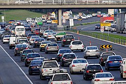
The 1969 Melbourne Transportation Plan was a road and rail transport plan for Melbourne, the state capital of Victoria, Australia, instituted by Henry Bolte's state government. Most prominently, the plan recommended the provision of an extensive freeway network, much of which has since been built.
Despite the majority of the printed material being devoted to non-car transport, 86 per cent of the projected budget was devoted to roads and parking, with only 14 per cent to other forms of transport.[1] The plan recommended 510 kilometres (320mi) of freeways for metropolitan Melbourne, as well as a number of railways. Of the latter, only the City Underground Loop was constructed. Proposed lines to Doncaster and Monash University (now Clayton Campus), and between Dandenong and Frankston,[2] were never built.
The plan was described by J.M. Thompson in Great Cities and their Traffic as "clearly ... a highway plan, not – as it is called – a comprehensive transport plan", and by historian Graeme Davison as "the most expansive and expensive freeway experiment in Australian history".[3]
In 1973, some freeway plans were pruned, especially those proposed for the inner city,[4] with State Premier Rupert Hamer cancelling all the road reservations for the unbuilt urban freeways in 1976.[2]
Some significant outer suburban freeway projects, under new branding, were built by subsequent governments, including CityLink (by the Kennett government in the 1990s), EastLink (by the Bracks government in the 2000s) and Peninsula Link (by the Napthine government in the 2010s).
Survey – completed for the Melbourne Transportation Committee by Wilbur Smith & Associates and Len T Frazer & Associates
Parking – completed for the Melbourne Transportation Committee by Wilbur Smith & Associates and Len T. Frazer & Associates
The Transportation Plan – completed by the Melbourne Transportation Committee.
The scope of the plan specified surveys of vehicular and personal travel, transport facilities, goods movement by road and rail, and central city parking. It built on the previous major Melbourne Transport Plans:
1929 Plan of General Development, Melbourne by the Metropolitan Town Planning Commission, and
1954 Melbourne Metropolitan Planning Scheme by the Melbourne Metropolitan Board of Works
and the minor
1961 Metropolitan Street Service Study by Traffic Commission Victoria.
Goals
The goals of the plan were to:
ensure safe, comfortable and efficient movement of people and goods throughout the design area
maintain a proper balance between public and private transport
make maximum use of the existing facilities and plans and the commitments already embodied in these plans
provide a transport service matched to the expectant demand throughout the design area
provide a system that could be adapted to meet changing conditions and be expanded beyond the design year
provide a transport network which could be implemented with as little interference to the commercial and community structure as possible
Funding
The costs of the development of the plan were shared by the four participating authorities:
Minor contributions were provided by Melbourne City Council and the Transport Regulation Board.
Methodology
The process adopted was:
Inventory of transport facilities, travel and developmental features of the study area
Forecast of 1985 travel requirements (estimated population of 3.7 million)
Evaluation of tentative 1985 plan
Periodic review
Organisation
The organisation required to develop the plan included:
Metropolitan Transportation Committee – a statutory body established in 1963 to advise government on all transport factors (and produce the third volume of the plan)
Technical Committee – consisting of senior representatives of transportation and other authorities on the main committee, its job was to oversee all technical matters arising during surveys and preparation of the plan
Consultants – Wilbur Smith and Associates (from New Haven, Connecticut) and Len T Frazer and Associates (Melbourne)
Study Group – engineers who were assigned from participating authorities to be trained by the consultants and assist in data collection and analysis This group was expanded to include economists responsible for costing the final plan
F1 Collingwood Freeway (Originally to connect the F9 Freeway at Southbank to the F19 Freeway at Fitzroy, passing through East Melbourne and Collingwood) - Abandoned
F2 North Hume Freeway (Originally to connect the Dingley Freeway to the now Hume Freeway at Thomastown) - Northern section partly built connecting Hume Freeway & Metropolitan Ring Road. Southern section - Abandoned
F4 East Calder Freeway (Originally passing through the Pascoe Vale Road Alignment to the F7 Freeway at Templestowe) - Abandoned
F5 East Greensborough Freeway - Partly built, but not of freeway standard (Greensborough Highway)
F5 West Metro Ring Road (Originally to pass through Essendon, Maribyrnong, East Sunshine and Footscray) - Partly built as the Western Ring Road
F6 North Chandler Freeway (Originally to connect the F5 Ring Road at Lalor to the F9 Freeway at Glen Iris) - Abandoned
F6 South Nepean Freeway (Originally to connect the F9 Freeway at Glen Iris to the F35 Freeway at Frankston) – Partly built as the Mornington Peninsula Freeway 1975–present
F5/F7 Northern Ring Road (Now known as the Metropolitan Ring Road), Partly Built 1996-1999
F35 North Scoresby Freeway/Eastern Ring Road (Now known as Eastlink), Built in 2008
A North East Link between the eastern and northern ring roads was originally designed but construction has begun as of 2020 with major works to begin mid 2021.
Parking
The plan included a proposed budget of $40 million for improvements in parking in the Melbourne central business district.
Buses
The plan included a proposed budget $58 million for bus improvements:
$50 million for 2,540 new buses
$8 million for new bus depots
Rail
Diagram showing Melbourne's rail network, including former and planned lines
The forecast budget for railway projects was $242 million. Planned rail projects included:[5]
Huntingdale - Ferntree Gully extension - Rowville Line (not built; now part of the PTV Network Development Plan)
Dandenong - Frankston line (not built)
Altona - Westona extension (built as part of the Altona - Laverton extension, opened 1985)
$8 million for extension of suburban electric service along existing lines to Werribee (completed 1983), Rockbank (electrification to Melton to come), Sunbury (completed to Sydenham in 2002, and Sunbury in 2012), Craigieburn (completed in 2007), Coldstream (line now closed), Hastings (not done) and Mornington (line now closed)
$42 million for route capacity improvements on existing lines (upgrades to automatic signalling, duplication of 19 miles (31km) of single track and 33 miles (53km) of new express tracks in existing rights of ways)
$2 million for new stations to be built on existing lines
$35 million on additional suburban trains
$15 million on modal interchanges (substantial increase in car and bus parking at suburban railway stations)
Trams
The plan included a proposed budget $55 million for 910 new trams.
This page is based on this Wikipedia article Text is available under the CC BY-SA 4.0 license; additional terms may apply. Images, videos and audio are available under their respective licenses.
