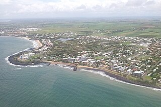
Bargara is a coastal town and suburb in the Bundaberg Region, Queensland, Australia. In the 2021 census, the suburb of Bargara had a population of 8,883 people.

Burnett Heads is a coastal town and locality in the Bundaberg Region, Queensland, Australia. In the 2021 census, the locality of Burnett Heads had a population of 2,908 people.

The City of Bundaberg was a local government area located in the Wide Bay–Burnett region of Queensland, Australia, encompassing the centre and inner suburbs of the regional city of Bundaberg. The city covered an area of 95.5 square kilometres (36.9 sq mi), and existed as a local government entity in various forms from 1881 until 2008, when it amalgamated with several other councils in the surrounding area to form the Bundaberg Region.
Innes Park is a coastal town and locality in the Bundaberg Region, Queensland, Australia. The town is 367 kilometres (228 mi) north of the state capital, Brisbane. In the 2021 census, the locality of Innes Park had a population of 2,653 people.

The Bundaberg Region is a local government area in the Wide Bay–Burnett region of Queensland, Australia, about 360 kilometres (220 mi) north of Brisbane, the state capital. It is centred on the city of Bundaberg, and also contains a significant rural area surrounding the city. It was created in 2008 from a merger of the City of Bundaberg with the Shires of Burnett, Isis and Kolan.
The Shire of Woongarra was a local government area located to the south and east of the regional city of Bundaberg. The shire, administered from Bundaberg itself, covered an area of 722.4 square kilometres (278.9 sq mi), and existed as a local government entity from 1885 until 1994, when it amalgamated with Gooburrum to form the Shire of Burnett.

The Woongarra Railway was a railway line from Bundaberg to Pemberton in Central Queensland, Australia.

Bundaberg Central is the central suburb and central business district of Bundaberg in the Bundaberg Region, Queensland, Australia. In the 2021 census, Bundaberg Central had a population of 162 people.

The Shire of Barolin was a local government area located in the Wide Bay–Burnett region of Queensland, Australia. It was the area south of the Burnett River but excluding the urban area of Bundaberg which was initially in Bundaberg Division. It existed from 1879 to 1917.

Bundaberg North is a suburb of Bundaberg in the Bundaberg Region, Queensland, Australia. It occupies the developed area north of the Burnett River, opposite the Bundaberg CBD. In the 2021 census, Bundaberg North had a population of 5,563 people.

Mon Repos is a coastal locality in the Bundaberg Region, Queensland, Australia. In the 2021 census, Mon Repos had a population of 24 people.
Kalkie is a suburb of Bundaberg in the Bundaberg Region, Queensland, Australia. In the 2021 census, Kalkie had a population of 2,968 people.

Coral Cove is a coastal locality in the Bundaberg Region, Queensland, Australia. It has been used as a diving point by tourists and contains the Coral Cove Golf course. In the 2021 census, Coral Cove had a population of 1,462 people.
Walkervale is a suburb of Bundaberg in the Bundaberg Region, Queensland, Australia. In the 2021 census, Walkervale had a population of 2,981 people.
Woongarra is a rural locality in the Bundaberg Region, Queensland, Australia. In the 2021 census, Woongarra had a population of 585 people.

Rubyanna is a rural locality in the Bundaberg Region, Queensland, Australia. In the 2021 census, Rubyanna had a population of 257 people.
Avenell Heights is a southern suburb of Bundaberg in the Bundaberg Region, Queensland, Australia. In the 2021 census, Avenell Heights had a population of 5,028 people.
Ashfield is a mixed residential and rural locality in the Bundaberg Region, Queensland, Australia. In the 2021 census, Ashfield had a population of 1,152 people.
Calavos is a rural locality in the Bundaberg Region, Queensland, Australia. In the 2021 census, Calavos had a population of 359 people.
Bundaberg–Bargara Road is a state-controlled district road in the Bundaberg region of Queensland, Australia. It is rated as a local road of regional significance (LRRS). It runs from the Isis Highway in Bundaberg West to Holland Street in Bargara, a distance of 14.4 kilometres (8.9 mi).


