Boyne Valley Queensland | |||||||||||||||
---|---|---|---|---|---|---|---|---|---|---|---|---|---|---|---|
Coordinates | 24°27′13″S151°17′34″E / 24.4536°S 151.2927°E Coordinates: 24°27′13″S151°17′34″E / 24.4536°S 151.2927°E | ||||||||||||||
Population | 301 (2021 census) [1] | ||||||||||||||
• Density | 0.2543/km2 (0.6587/sq mi) | ||||||||||||||
Postcode(s) | 4680 | ||||||||||||||
Area | 1,183.6 km2 (457.0 sq mi) | ||||||||||||||
Time zone | AEST (UTC+10:00) | ||||||||||||||
Location |
| ||||||||||||||
LGA(s) | Gladstone Region | ||||||||||||||
State electorate(s) | Callide | ||||||||||||||
Federal division(s) | Flynn | ||||||||||||||
|
The Boyne Valley is a rural locality in Gladstone Region, Queensland, Australia. [2] The locality contains four small towns: Nagoorin, Ubobo, Builyan, and Many Peaks. In the 2016 census, Boyne Valley had a population of 358 people. [3] At the 2021 census the population had dropped to 301. [1]
It is in the valley of the Boyne River, in Central Queensland, approximately 500 kilometres (310 mi) north of Brisbane and 70 kilometres (43 mi) south west of Gladstone. "The Valley" as locals call it, is part of Gladstone's hinterland. Formerly within the Shire of Calliope, in 2008 it became part of Gladstone Region. It is in close proximity to Kroombit Tops National Park.
The Gladstone–Monto Road runs through from north to south-west. [4]
Nagoorin State School opened on 18 October 1915. [5]
Builyan State School opened on 4 December 1922. [5]
Ubobo State School opened on 23 March 1927. [5]
The Gladstone to Monto railway line opened its first section from Byellee (previously known as Boyne Valley Junction) to Many Peaks on 25 July 1910 with the following stations on the line within Boyne Valley:[ citation needed ]
with the second section to Barrimoon completed on 17 August 1926 including:
The line closed to regular services in 2002 with the final train on the line being a steam special run from Monto to Maryborough in 2005.[ citation needed ]
At the 2006 census, Boyne Valley had a population of 646. [7]
In the 2011 census, Boyne Valley had a population of 379 people. [8]
Boyne Valley has a number of heritage-listed sites, including:
Ubobo State School is a government primary (Prep-6) school for boys and girls at Cedarvale Road ( 24°24′24″S151°19′18″E / 24.4067°S 151.3217°E ). [13] [14] In 2017, the school had an enrolment of 12 students with 3 teachers (2 full-time equivalent) and 4 non-teaching staff (2 full-time equivalent). [15] The school was temporarily closed in late 2019 due to a lack of enrolments, and remains closed as of July 2022.
Builyan State School is a government primary (Prep-6) school for boys and girls at Gladstone Road ( 24°31′45″S151°23′07″E / 24.5293°S 151.3854°E ). [16] In 2017, the school had an enrolment of 8 students with 2 teachers (1 full-time equivalent) and 4 non-teaching staff (2 full-time equivalent). [15] Enrolments increased to 10 students in February 2021. [17]
Nagoorin State School is a government primary (Prep-6) school for boys and girls at 2 Ubobo Street ( 24°21′06″S151°18′00″E / 24.3516°S 151.2999°E ). [18] In 2017, the school had an enrolment of 12 students with 2 teachers (1 full-time equivalent) and 4 non-teaching staff (2 full-time equivalent). [15] Enrolments increased to 23 students in February 2021. [19]
The three schools get together on a regular basis, providing students with the opportunity to learn and socialise with children of a similar age.
There are no secondary schools in Boyne Valley. The nearest is Miriam Vale State School which offers secondary schooling to Year 10. For Years 11 and 12, the nearest schools are Gladstone State High School, Rosedale State School and Monto State High School. [20]
Gladstone is a coastal city in the Gladstone Region, Queensland, Australia. Gladstone, together with Boyne Island and Tannum Sands, had an estimated urban population of 50,317 at August 2021. This urban area covers 246.1 km2 (95.0 sq mi).
Tannum Sands is a coastal town and locality in the Gladstone Region, Queensland, Australia.
Monto is a rural town and locality in the North Burnett Region, Queensland, Australia. In the 2021 census, Monto had a population of 1,156 people.
Lake Awoonga was formed on the Boyne River by the dam located 30 km (19 mi) from Gladstone, in Central Queensland, Australia. It is approximately 30 minutes drive from Gladstone, via Benaraby.
The Shire of Calliope was a local government area in the Capricornia region of Queensland, Australia. It was centred on the town of Calliope.
Nagoorin is a rural town in Gladstone Region, Queensland, Australia. It is one of four small townships within the locality of Boyne Valley along with Ubobo, Builyan, and Many Peaks.
Ubobo is a rural town in the locality of Boyne Valley in the Gladstone Region, Queensland, Australia.
Builyan is a town in Gladstone Region, Central Queensland, Australia. It is one of four small townships within the locality of Boyne Valley along with Nagoorin, Ubobo, and Many Peaks.
Many Peaks is a town in Gladstone Region in Queensland, Australia. It is one of four small townships within the locality of Boyne Valley along with Nagoorin, Builyan and Ubobo.
Gladstone Region is a local government area in Queensland, Australia. The council covers an area of 10,484 square kilometres (4,048 sq mi), had an estimated resident population at 30 June 2018 of 62,979, and has an estimated operating budget of A$84 million.
The Mungar Junction to Monto railway line is a 267-kilometre (166 mi) railway in Queensland, Australia. Progressively opened in eleven stages between 1889 and 1928 the line branched from the North Coast line at Mungar Junction a short distance west of Maryborough and followed a westerly route towards Biggenden and Gayndah before turning north via Mundubbera and Eidsvold to Monto. It is also known as the Gayndah Monto Branch Railway.
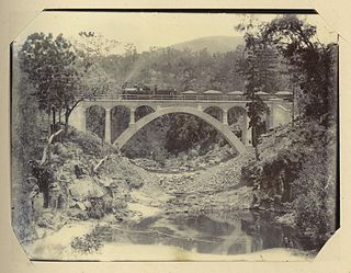
Byellee to Monto Branch Railway was a branch railway that branched off the Boyne Valley west of Gladstone in Queensland, Australia.The Boyne Valley region was predominantly a dairying region and a railway had little justification. However a branch was justified in 1906 on the basis of large traffic in timber, fuel, limestone and flexing ores. Progressively opened between 1910 and 1931 the line branched from the North Coast line at Byellee a short distance west of Gladstone and struck a south-westerly route via Many Peaks and Mungungo to Monto.
Ideraway is a rural town and locality in the North Burnett Region, Queensland, Australia. In the 2016 census, the locality of Ideraway had a population of 38 people.
Yarwun is a rural coastal town and locality in the Gladstone Region, Queensland, Australia. In the 2016 census the locality of Yarwun had a population of 119 people.
Soldier Settler House is a heritage-listed homestead at Gladstone-Monto Road, Ubobo, Gladstone Region, Queensland, Australia. It was built in 1920. It is also known as Hecstanvale. It was added to the Queensland Heritage Register on 28 September 2001.
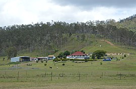
Boynedale is a rural locality in the Gladstone Region, Queensland, Australia. In the 2016 census, Boynedale had a population of 17 people.
Kalpowar is a town in the North Burnett Region and a locality split between the North Burnett Region and the Bundaberg Region, in Queensland, Australia. In the 2016 census, the locality of Kalpowar had a population of 67 people.
Bancroft is a rural locality in the North Burnett Region, Queensland, Australia. In the 2016 census, Bancroft had a population of 96 people.
Gladstone–Monto Road is a 132 kilometres (82 mi) road route in the Gladstone and North Burnett regions of Queensland, Australia. The entire route is signed as State Route 69.
The Boyne Burnett Inland Rail Trail is a recreational route for walkers, cyclists and horse riders from Taragoola to Gayndah. It uses the closed Gladstone to Monto and Mungar Junction to Monto railway corridors in Queensland, Australia.