Baffle Creek, Queensland

Last updated

Baffle Creek
Queensland
Australia Queensland location map.svg
Red pog.svg
Baffle Creek
Coordinates 24°29′20″S151°55′30″E / 24.4888°S 151.9250°E / -24.4888; 151.9250 (Baffle Creek (centre of locality))
Population155 (2021 census) [1]
 • Density3.298/km2 (8.54/sq mi)
Postcode(s) 4674
Area47.0 km2 (18.1 sq mi)
Time zone AEST (UTC+10:00)
LGA(s) Gladstone Region
State electorate(s) Burnett
Federal division(s) Division of Flynn
Suburbs around Baffle Creek:
Oyster Creek Deepwater Rules Beach
Euleilah Baffle Creek Rules Beach
Euleilah Rosedale Winfield

Baffle Creek is a rural locality in the Gladstone Region, Queensland, Australia. [2] In the 2021 census, Baffle Creek had a population of 155 people. [1]

Contents

The neighbourhood of Wartburg is within the locality ( 24°30′07″S151°55′52″E / 24.50194°S 151.93111°E / -24.50194; 151.93111 (Wartburg, Queensland) ). [3]

Geography

Baffle Creek (the watercourse) forms the southern and south-western boundaries. [4]

History

The area on Baffle Creek was first settled in 1908 by Prussian and German immigrants who were recruited by Apostle. H. F. Niemeyer of the Apostolic Church of Queensland in Hatton Vale near Ipswich. The government land orders they had expected to receive were not available, so they had to wait for six months living on a hill that they called Wartburg meaning waiting place. [5]

In 1911, a sugar mill was built by Albert Kleinschmidt (who had another sugar mill in Bundaberg). The mill produced brown sugar which was taken elsewhere for further refining. The mill was closed in 1919 as it was not a successful venture. [5]

Wartburg State School opened on 11 August 1913. [6] [7] [8]

In 1921, a shop storeroom off the Coast Road was remodelled to become St Paul's Lutheran Church. It was officially opened on Sunday 17 July 1921. It was 10 miles (16 km) from Rosedale near the Baffle Creek. It is on the south-western corner of the Coast Road and Bayfield Road leading to the creek ( 24°30′16″S151°55′48″E / 24.5045°S 151.9299°E / -24.5045; 151.9299 (St Paul's Lutheran Church) ). [9] [10] [11] The church bell was installed in 1923. The church was enlarged and the bell tower was remodelled in 1947. [12]

On 26 November 2018, the Queensland Government ordered the evacuation of Baffle Creek, Deepwater and Rules Beach due to a "dangerous and unpredictable" bushfire 50-kilometre (31 mi) wide and covering 5,000 hectares (12,000 acres) with flames of 10 to 12 metres (33 to 39 ft) high during an extreme heatwave. [13]

Demographics

In the 2011 census, Baffle Creek had a population too low to separately report and was aggregated with the neighbouring locality of Deepwater which had a combined population of 548 people. [14]

In the 2016 census, Baffle Creek had a population of 156 people. [15]

In the 2021 census, Baffle Creek had a population of 155 people. [1]

Heritage listings

Baffle Creek has a number of heritage-listed sites, including:

Education

Wartburg State School is a government primary (Early Childhood - Year 6) school for boys and girls at 585 Coast Road in Baffle Creek ( 24°30′09″S151°55′51″E / 24.5024°S 151.9309°E / -24.5024; 151.9309 (Wartburg State School) ). [16] [17] In 2013, the school had 55 students and 4 teachers (3 full-time equivalent). [18] In 2023, the school had 19 students. [19]

There are no secondary schools in Baffle Creek. The nearest government secondary school is Rosedale State School (to Year 12) in neighbouring Rosedale to the south. [20]

Related Research Articles

<span class="mw-page-title-main">Miriam Vale</span> Town in Queensland, Australia

Miriam Vale is a rural town and locality in the Gladstone Region, Queensland, Australia. In the 2021 census, the locality of Miriam Vale had a population of 493 people.

<span class="mw-page-title-main">Agnes Water, Queensland</span> Town in Queensland, Australia

Agnes Water is a coastal town and a locality in the Gladstone Region, Queensland, Australia. In the 2021 census, the locality of Agnes Water had a population of 2,729 people.

<span class="mw-page-title-main">Burnett Heads, Queensland</span> Town in Queensland, Australia

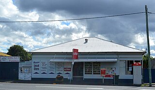
Burnett Heads is a coastal town and locality in the Bundaberg Region, Queensland, Australia. In the 2021 census, the locality of Burnett Heads had a population of 2,908 people.

<span class="mw-page-title-main">Shire of Miriam Vale</span> Local government area in Queensland, Australia

The Shire of Miriam Vale was a local government area near Gladstone in Queensland, Australia. The administrative centre was the town of Miriam Vale.

<span class="mw-page-title-main">Wallaville</span> Town in Queensland, Australia

Wallaville is a rural town and locality in the Bundaberg Region, Queensland, Australia. It is 372 kilometres (231 mi) north of the state capital, Brisbane and 43 kilometres (27 mi) south west of the regional centre of Bundaberg. In the 2021 census, the locality of Wallaville had a population of 363 people.

Turkey Beach is a coastal town and locality in the Gladstone Region, Queensland, Australia. In the 2021 census, the locality of Turkey Beach had a population of 148 people.

<span class="mw-page-title-main">Rosedale, Queensland</span> Town in Queensland, Australia

Rosedale is a rural town and locality split between the Gladstone Region and the Bundaberg Region in central Queensland, Australia. In the 2021 census, the locality of Rosedale had a population of 452 people.

<span class="mw-page-title-main">South Kolan</span> Town in Queensland, Australia

South Kolan is a rural locality in the Bundaberg Region, Queensland, Australia. In the 2021 census, the locality of South Kolan had a population of 1,258 people.

<span class="mw-page-title-main">Woongoolba, Queensland</span> Suburb of Gold Coast, Queensland, Australia

Woongoolba is a coastal rural locality in the northern part of City of Gold Coast, Queensland, Australia. In the 2021 census, Woongoolba had a population of 282 people.

<span class="mw-page-title-main">Bororen</span> Town in Queensland, Australia

Bororen is a rural town and locality in the Gladstone Region, Queensland, Australia. In the 2021 census, the locality of Bororen had a population of 399 people.

Lowmead is a rural town and locality in the Gladstone Region, Queensland, Australia. In the 2021 census, the locality of Lowmead had a population of 179 people.

Winfield is a rural locality in the Bundaberg Region, Queensland, Australia. In the 2021 census, Winfield had a population of 154 people.

Berajondo is a rural locality in the Gladstone Region, Queensland, Australia. In the 2021 census, Berajondo had a population of 112 people.

Colosseum is a rural locality in the Gladstone Region, Queensland, Australia. In the 2021 census, Colosseum had a population of 184 people.

Deepwater is a coastal locality in the Gladstone Region, Queensland, Australia. In the 2021 census, Deepwater had a population of 287 people.

Rules Beach is a coastal town and a locality in the Gladstone Region, Queensland, Australia. In the 2021 census, the locality of Rules Beach had a population of 56 people.

<span class="mw-page-title-main">Captain Creek, Queensland</span> Suburb of Gladstone Region, Queensland, Australia

Captain Creek is a rural locality in the Gladstone Region, Queensland, Australia. In the 2021 census, Captain Creek had a population of 452 people.

Taunton is a rural locality in the Gladstone Region, Queensland, Australia. In the 2021 census, Taunton had a population of 57 people.

Mount Maria is a rural locality in the Gladstone Region, Queensland, Australia. In the 2021 census, Mount Maria had a population of 225 people.

Euleilah is a rural locality in the Gladstone Region, Queensland, Australia. In the 2021 census, Euleilah had a population of 202 people.

References

  1. 1 2 3 Australian Bureau of Statistics (28 June 2022). "Baffle Creek (SAL)". 2021 Census QuickStats. Retrieved 28 February 2023. OOjs UI icon edit-ltr-progressive.svg
  2. "Baffle Creek – locality in Gladstone Region (entry 46587)". Queensland Place Names. Queensland Government . Retrieved 27 December 2020.
  3. "Wartburg (entry 36637)". Queensland Place Names. Queensland Government . Retrieved 4 July 2014.
  4. "Baffle Creek, Queensland" (Map). Google Maps . Retrieved 20 August 2021.
  5. 1 2 3 "Baffle Creek Sugar Mill". Local Heritage Register. Gladstone Regional Council. Archived from the original on 23 March 2019. Retrieved 4 July 2014.
  6. "Opening and closing dates of Queensland Schools". Queensland Government . Retrieved 3 July 2014.
  7. "Wartburg State School". Wartburg State School. Retrieved 4 July 2014.
  8. "Baffle Creek" (PDF). Gladstone Regional Council. Archived from the original (PDF) on 14 July 2014. Retrieved 4 July 2014.
  9. "BAFFLE CREEK". The Bundaberg Mail . Vol. 51, no. 7, 330. Queensland, Australia. 20 July 1921. p. 5. Retrieved 30 November 2021 via National Library of Australia.
  10. "St Paul's Lutheran Church". Churches Australia. Archived from the original on 30 November 2021. Retrieved 30 November 2021.
  11. "Coast Rd, Baffle Creek QLD 4674" (Map). Google Maps . Retrieved 30 November 2021.
  12. 1 2 "St Paul's Lutheran Church". Local Heritage Register. Gladstone Regional Council. Archived from the original on 30 November 2021. Retrieved 30 November 2021.
  13. Williams, Patrick (26 November 2018). "Queensland bushfire sparks warning for people in Deepwater and Baffle Creek to 'evacuate immediately'". ABC News . Retrieved 26 November 2018.
  14. Australian Bureau of Statistics (31 October 2012). "Deepwater (SSC)". 2011 Census QuickStats. Retrieved 3 July 2014. OOjs UI icon edit-ltr-progressive.svg
  15. Australian Bureau of Statistics (27 June 2017). "Baffle Creek (SSC)". 2016 Census QuickStats. Retrieved 20 October 2018. OOjs UI icon edit-ltr-progressive.svg
  16. "Wartburg State School". Wartburg State School. 29 November 2020. Retrieved 15 September 2024.
  17. "Wartburg State School". Google Street View . November 2020. Retrieved 16 September 2024.
  18. "2013 School Annual Reporr" (PDF). Wartburg State School. Wartburg State School. Archived from the original (PDF) on 14 July 2014. Retrieved 4 July 2014.
  19. "Wartburg State School: Annual Report: 2023" (PDF). Wartburg State Schoool. p. 2. Retrieved 16 September 2024.
  20. "Layers: Locality; Schools and school catchments". Queensland Globe. Queensland Government . Retrieved 15 September 2024.

Further reading