West Stowe, Queensland

Last updated

West Stowe
Queensland
Australia Queensland location map.svg
Red pog.svg
West Stowe
Coordinates 23°55′22″S151°07′47″E / 23.9227°S 151.1297°E / -23.9227; 151.1297 (West Stowe (centre of locality))
Population391 (SAL 2021) [1]
Postcode(s) 4680
Area120.6 km2 (46.6 sq mi)
Time zone AEST (UTC+10:00)
Location
LGA(s) Gladstone Region
State electorate(s) Gladstone
Federal division(s) Flynn
Suburbs around West Stowe:
Aldoga Yarwun Byellee
East End West Stowe Beecher
Wooderson Calliope
River Ranch
Burua

West Stowe is a rural locality in the Gladstone Region, Queensland, Australia. [2] It is immediately west of the Gladstone urban area and immediately south of the small town of Yarwun. [3] In the 2021 census, West Stowe had a population of 391 people. [4]

Contents

Geography

The Calliope River forms the southern boundary and most of the eastern boundary. [5] [6]

The Bruce Highway enters the locality from the south (River Ranch) and exists to the south-west (East End).The Gladstone–Mount Larcom Road (State Route 58) runs along part of the northern boundary. [7]

The North Coast railway line also forms part of the north and north-eastern boundary. There are two stations on the north-east boundary: [7]

The Wiggins Island Balloon Loop is a 13-kilometre (8.1 mi) balloon loop within West Stowe. The loop is for unloading coal trains and transferring the coal onto a conveyor belt to the Wiggins Island Coal Export Terminal in Callemondah where it is loaded onto ships. [10]

The terrain varies from 10 to 314 metres (33 to 1,030 ft) above sea level. There are a number of named peaks, all in the north of the locality: [6]

Calliope Conservation Park is in the north-east of the locality and there are three sections of the Mount Stowe State Forest in the north of the locality. Apart from these protected areas, the land use is predominantly grazing on native vegetation. [3]

History

The locality was officially named and bounded on 27 August 1999. It most likely takes its name from the parish. [2] [16]

The Wiggins Island Balloon Loop was built in 2012 to 2013. [10]

Demographics

In the 2016 census, West Stowe had a population of 311 people. [17]

In the 2021 census, West Stowe had a population of 391 people. [4]

Education

There are no schools in West Stowe. The nearest government primary schools are: [18]

The nearest government secondary schools are: [18]

There are also non-government schools available in Gladstone. [18]

Related Research Articles

<span class="mw-page-title-main">Calliope, Queensland</span> Town in Queensland, Australia

Calliope is a rural town and locality in the Gladstone Region, Queensland, Australia. In the 2021 census, Calliope had a population of 5,263 people.

<span class="mw-page-title-main">Mount Larcom, Queensland</span> Town in Queensland, Australia

Mount Larcom is the name of a mountain, a rural town and locality in the Gladstone Region, Queensland, Australia. In the 2016 census, the locality of Mount Larcom had a population of 361 people.

<span class="mw-page-title-main">Shire of Calliope</span> Local government area in Queensland, Australia

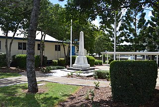
The Shire of Calliope was a local government area in the Capricornia region of Queensland, Australia. It was centred on the town of Calliope.

<span class="mw-page-title-main">Raglan, Queensland</span> Town in Queensland, Australia

Raglan is a rural town and locality in the Gladstone Region, Queensland, Australia. In the 2016 census, the locality of Raglan had a population of 146 people.

<span class="mw-page-title-main">East End, Queensland</span> Suburb of Gladstone Region, Queensland, Australia

East End is a rural locality in the Gladstone Region, Queensland, Australia. In the 2016 census, East End had a population of 59 people.

Bracewell is a rural locality in the Gladstone Region, Queensland, Australia. In the 2016 census, Bracewell had a population of 196 people.

Machine Creek is a rural locality in the Gladstone Region, Queensland, Australia. In the 2016 census, Machine Creek had a population of 120 people.

<span class="mw-page-title-main">Yarwun, Queensland</span> Suburb of Gladstone Region, Queensland, Australia

Yarwun is a rural town and coastal locality in the Gladstone Region, Queensland, Australia. In the 2021 census, the locality of Yarwun had a population of 89 people.

Boynedale is a rural locality in the Gladstone Region, Queensland, Australia. In the 2016 census, Boynedale had a population of 17 people.

<span class="mw-page-title-main">Kalpowar</span> Town in Queensland, Australia

Kalpowar is a town in the North Burnett Region and a locality split between the North Burnett Region and the Bundaberg Region, in Queensland, Australia. In the 2016 census, the locality of Kalpowar had a population of 67 people.

Targinnie is a coastal locality in the Gladstone Region, Queensland, Australia. In the 2021 census, Targinnie had a population of 31 people.

<span class="mw-page-title-main">Tablelands, Queensland (Gladstone Region)</span> Suburb of Gladstone Region, Queensland, Australia

Tablelands is a rural locality in the Gladstone Region, Queensland, Australia. In the 2021 census, Tablelands had a population of 9 people.

<span class="mw-page-title-main">Callemondah</span> Suburb of Gladstone, Queensland, Australia

Callemondah is a coastal suburb of Gladstone in the Gladstone Region, Queensland, Australia. It contains the Port of Gladstone. In the 2016 census Callemondah had a population of 18 people.

Iveragh is a rural locality in the Gladstone Region, Queensland, Australia.

Beecher is a rural locality in the Gladstone Region, Queensland, Australia. In the 2016 census, Beecher had a population of 863 people.

The Narrows is a coastal locality in the Gladstone Region, Queensland, Australia. In the 2021 census, The Narrows had a population of 0 people.

Byellee is an industrial suburb of Gladstone in the Gladstone Region, Queensland, Australia. In the 2021 census, Byellee had a population of 0 people.

<span class="mw-page-title-main">Mount Alma, Queensland</span> Suburb of Gladstone Region, Queensland, Australia

Mount Alma is a rural locality in the Gladstone Region, Queensland, Australia. In the 2016 census, Mount Alma had a population of 47 people.

Gladstone–Benaraby Road is a continuous 19.4 kilometres (12.1 mi) road route in the Gladstone region of Queensland, Australia. Much of the route is signed as State Route 58. Gladstone–Benaraby Road is a state-controlled regional road. As part of State Route 58 it provides an alternate route between Benaraby and Mount Larcom. It is also part of the shortest route from Gladstone to the south of the state.

Gladstone–Mount Larcom Road is a continuous 32.1 kilometres (19.9 mi) road route in the Gladstone region of Queensland, Australia. The route is signed as State Route 58. Gladstone–Mount Larcom Road is a state-controlled regional road. As part of State Route 58 it provides an alternate route between Mount Larcom and Benaraby. It is also part of the shortest route from Gladstone to the north of the state.

References

  1. Australian Bureau of Statistics (28 June 2022). "West Stowe (suburb and locality)". Australian Census 2021 QuickStats. Retrieved 28 June 2022.  OOjs UI icon edit-ltr-progressive.svg
  2. 1 2 "West Stowe – locality in Gladstone Region (entry 49124)". Queensland Place Names. Queensland Government . Retrieved 16 November 2018.
  3. 1 2 "Layers: Locality; Protected areas and forests; Land use". Queensland Globe. Queensland Government. Archived from the original on 19 December 2017. Retrieved 25 February 2024.
  4. 1 2 Australian Bureau of Statistics (28 June 2022). "West Stowe (SAL)". 2021 Census QuickStats. Retrieved 28 February 2023. OOjs UI icon edit-ltr-progressive.svg
  5. Google (15 September 2021). "West Stowe, Queensland" (Map). Google Maps . Google. Retrieved 15 September 2021.
  6. 1 2 "Layers: Locality; Mountains and ranges; Contours; Watercourses". Queensland Globe. Queensland Government. Archived from the original on 19 December 2017. Retrieved 25 February 2024.
  7. 1 2 "Layers: Locality; Road and rail". Queensland Globe. Queensland Government. Archived from the original on 19 December 2017. Retrieved 25 February 2024.
  8. 1 2 "Railway stations and sidings - Queensland". Queensland Open Data. Queensland Government. 2 October 2020. Archived from the original on 5 October 2020. Retrieved 5 October 2020.
  9. "Mount Miller – railway station in the Gladstone Region (entry 23094)". Queensland Place Names. Queensland Government . Retrieved 26 February 2024.
  10. 1 2 "Wiggins Island Rail Project: Balloon Loop" (PDF). Aurizon . p. 1. Archived (PDF) from the original on 11 March 2020. Retrieved 26 February 2024.
  11. 1 2 3 4 "Mountain peaks and capes - Queensland". Queensland Open Data. Queensland Government. 12 November 2020. Archived from the original on 25 November 2020. Retrieved 25 November 2020.
  12. "Mount Sugarloaf – mountain in Gladstone Region (entry 32752)". Queensland Place Names. Queensland Government . Retrieved 25 November 2020.
  13. "Mount Martin – mountain in Gladstone Region (entry 21126)". Queensland Place Names. Queensland Government . Retrieved 25 November 2020.
  14. "Mount Stowe – mountain in Gladstone Region (entry 32621)". Queensland Place Names. Queensland Government . Retrieved 25 November 2020.
  15. "White Hill – mountain in Gladstone Region (entry 37284)". Queensland Place Names. Queensland Government . Retrieved 25 November 2020.
  16. "West Stowe – parish in the Gladstone Region (entry 37079)". Queensland Place Names. Queensland Government . Retrieved 16 November 2018.
  17. Australian Bureau of Statistics (27 June 2017). "West Stowe (SSC)". 2016 Census QuickStats. Retrieved 20 October 2018. OOjs UI icon edit-ltr-progressive.svg
  18. 1 2 3 "Layers: Locality; Schools and school catchments". Queensland Globe. Queensland Government. Archived from the original on 19 December 2017. Retrieved 25 February 2024.