Callemondah Gladstone, Queensland | |||||||||||||||
---|---|---|---|---|---|---|---|---|---|---|---|---|---|---|---|
Gladstone Powerhouse with the Calliope River beyond, 2005 | |||||||||||||||
![]() | |||||||||||||||
Coordinates | 23°50′34″S151°12′51″E / 23.8427°S 151.2141°E | ||||||||||||||
Population | 30 (2021 census) [1] | ||||||||||||||
• Density | 0.65/km2 (1.67/sq mi) | ||||||||||||||
Postcode(s) | 4680 | ||||||||||||||
Area | 46.5 km2 (18.0 sq mi) | ||||||||||||||
Time zone | AEST (UTC+10:00) | ||||||||||||||
Location |
| ||||||||||||||
LGA(s) | Gladstone Region | ||||||||||||||
State electorate(s) | Gladstone | ||||||||||||||
Federal division(s) | Flynn | ||||||||||||||
|
Callemondah is a coastal suburb of Gladstone in the Gladstone Region, Queensland, Australia. [2] It contains the Port of Gladstone. In the 2021 census, Callemondah had a population of 30 people. [1]
The Calliope River forms the south-western boundary of the suburb before flowing north through the suburb into the bay ( 23°48′59″S151°13′37″E / 23.8163°S 151.2269°E ) of Port Curtis ( 23°49′05″S151°15′20″E / 23.8181°S 151.2556°E ). [3] [4] Auckland Inlet ( 23°49′56″S151°15′07″E / 23.8322°S 151.2519°E ) forms its eastern boundary separating it from Gladstone Central. [5] Auckland Creek flows into Auckland Inlet ( 23°52′00″S151°14′00″E / 23.8666°S 151.2333°E ). [6] [7]
Offshore are the following islands and rocks:
and the following passages:
The land use is predominantly industrial with a number of coal port facilities with associated stockpiles at the Port of Gladstone ( 23°49′13″S151°14′33″E / 23.8202°S 151.2425°E ), the NRG Gladstone Powerhouse ( 23°51′06″S151°13′08″E / 23.8516°S 151.2190°E ) which is the largest powerhouse in Queensland, railway servicing facilities and numerous other industrial businesses. [5]
The Callemondah railway station and its associated marshalling yards are located on the southern boundary of the suburb ( 23°51′56″S151°13′36″E / 23.8656°S 151.2266°E ). [14] It is on the North Coast railway line, the Moura railway line, the Blackwater railway line and a number private rail lines within Callemondah servicing various industrial facilities. [5] Gladstone Power House railway station is on the North Coast line to the immediate east of the Gladstone Powerhouse ( 23°51′13″S151°13′16″E / 23.8537°S 151.2211°E ). [15] Clinton railway station (formerly known as Golding railway station) serves the Clinton coal loading wharf in the north of the suburb ( 23°49′43″S151°13′54″E / 23.8285°S 151.2318°E ). [15]
The Gladstone–Mount Larcom Road runs through from east to west. [16]
In January 1847 Colonel George Barney led a settlement party from Sydney to Port Curtis to establish the short-lived Colony of North Australia. They travelled in the 628-ton barque Lord Auckland which was built in Calcutta in 1836. The ship stranded on a shoal in Port Curtis on 25 January 1847, but was refloated and repaired in a creek, now known as Auckland Creek. [17] [6] Auckland Inlet is also named after the barque. [7]
The suburb takes its name from the railway station which was assigned in August 1967 by Queensland Railways Department to their locomotive servicing facility, using an Aboriginal word (probably from a New South Wales area), meaning plenty of hills. [2]
In the 2016 census, Callemondah had a population of 18 people. [18]
In the 2021 census, Callemondah had a population of 30 people. [1]
There are no schools in Callemondah. The nearest government primary schools are Gladstone Central State School in neighbouring Gladstone Central to the east and Gladstone West State School in neighbouring West Gladstone to the south-east. The nearest government secondary school is Gladstone State High School in neighbouring West Gladstone to the south-east. [5]
Central Queensland University operates its Gladstone Marina campus on Bryan Jordan Drive in the north-east tip of Callemondah ( 23°50′08″S151°14′55″E / 23.8356°S 151.2487°E ), [19] which is linked by a bridge across the Auckland Inlet to Gladstone Central. As the name suggests, the campus is adjacent to the Gladstone Marina. [20]
Lake Callemondah is an artificial lake ( 23°51′32″S151°13′57″E / 23.8590°S 151.2324°E ) at the end of Joe Joseph Drive. It is adjacent to Auckland Inlet but separated from it by a rock and concrete wall. [21] The lake receives stormwater run-off from the roofs and streets of the local area. In 1999 barramundi fingerlings were first introduced into the lake. As the fish mature, they are able to migrate into Auckland Inlet and beyond. Up to 2,800 new fingerlings are added to the lake each year. By tagging the fish, it has been established most of the mature fish stay in the Gladstone area, but one has been found up 36 kilometres (22 mi) away in the Boyne River. [22] [23]
Calliope River Sewage Treatment Plant is on Hansen Road ( 23°50′42″S151°13′15″E / 23.8450°S 151.2208°E ). The treated wastewater is either recycled or discharged into the Calliope River. [19] [24] [25]
Gladstone Marina is a 51.4-hectare (127-acre) marina at Alf O'Rourke Drive ( 23°49′51″S151°14′41″E / 23.8307°S 151.2446°E ). It has 320 mooring berths. Nearby is a boat ramp and floating walkway ( 23°49′44″S151°14′26″E / 23.8288°S 151.2405°E ). It is managed by the Gladstone Ports Corporation Limited. [26] [27] [28]
There is a boat ramp and floating walkway off Hanson Road near the Gladstone Power Station providing access to the Calliope River ( 23°50′48″S151°12′46″E / 23.8466°S 151.2127°E ). It is managed by the Gladstone Ports Corporation Limited. [27]
There are a number of parks in the suburb, including:
Powerhouse Lookout is at the top of Jeff Ringland Drive ( 23°51′19″S151°13′36″E / 23.8554°S 151.2267°E ). [30] [31]
Gladstone is a coastal city in the Gladstone Region, Queensland, Australia. In the 2016 census, the town of Gladstone had a population of 34,703 people.
Calliope is a rural town and locality in the Gladstone Region, Queensland, Australia. In the 2021 census, the locality of Calliope had a population of 5,263 people.
Seventeen Seventy, sometimes written 1770 or Town of 1770, is a coastal town and locality in the Gladstone Region, Queensland, Australia. In the 2021 census, the locality of Seventeen Seventy had a population of 125 people.
The Shire of Calliope was a local government area in the Capricornia region of Queensland, Australia. It was centred on the town of Calliope.
The Port of Gladstone is Queensland's largest multi-commodity port and the fifth largest multi-commodity port in Australia. It is the world's fourth largest coal exporting terminal. It is within the locality of Callemondah in Gladstone in Central Queensland and is located about 525 kilometres (326 mi) north of Brisbane at Latitude of 23°49.61'S, Longitude 151°34.6’E. It is owned and managed by Gladstone Ports Corporation, which is a statutory corporate body of the Government of Queensland.
Barney Point is a beachside suburb of Gladstone in the Gladstone Region, Queensland, Australia. In the 2021 census, Barney Point had a population of 1,065 people.
East End is a rural locality in the Gladstone Region, Queensland, Australia. In the 2021 census, East End had a population of 88 people.
Toolooa is a suburb of Gladstone in the Gladstone Region, Queensland, Australia. In the 2021 census, Toolooa had a population of 992 people.
Gladstone Central is a coastal suburb of Gladstone in the Gladstone Region, Queensland, Australia. It is the historic centre and central business district of the city of Gladstone and the seat of the Gladstone Regional Council. In the 2021 census, Gladstone Central had a population of 1,550 people.
West Gladstone is a suburb of Gladstone in the Gladstone Region, Queensland, Australia. In the 2021 census, West Gladstone had a population of 4,844 people.
Yarwun is a rural town and coastal locality in the Gladstone Region, Queensland, Australia. In the 2021 census, the locality of Yarwun had a population of 89 people.
The Calliope River Historical Village is an open-air museum at 50951 Bruce Highway beside the Calliope River in River Ranch in the Gladstone Region, Queensland, Australia. It is operated by the Port Curtis Historical Society.
Boynedale is a rural locality in the Gladstone Region, Queensland, Australia. In the 2021 census, Boynedale had a population of 13 people.
O'Connell is a suburb of Gladstone in the Gladstone Region, Queensland, Australia. In the 2021 census, O'Connell had a population of 399 people.
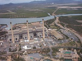
South Trees is a coastal industrial suburb of Gladstone in the Gladstone Region, Queensland, Australia. In the 2021 census, South Trees had "no people or a very low population".
Beecher is a rural locality in the Gladstone Region, Queensland, Australia. In the 2021 census, Beecher had a population of 876 people.
West Stowe is a rural locality in the Gladstone Region, Queensland, Australia. It is immediately west of the Gladstone urban area and immediately south of the small town of Yarwun. In the 2021 census, West Stowe had a population of 391 people.
Gladstone Harbour is a locality in the Gladstone Region, Queensland, Australia. There are three small towns in Gladstone Harbour, all on Facing Island: Northcliffe, Farmers Point and Gatcombe. In the 2021 census, Gladstone Harbour had a population of 24 people.
Byellee is an industrial suburb of Gladstone in the Gladstone Region, Queensland, Australia. In the 2021 census, Byellee had "no people or a very low population".
Gladstone–Mount Larcom Road is a continuous 32.1 kilometres (19.9 mi) road route in the Gladstone region of Queensland, Australia. The route is signed as State Route 58. Gladstone–Mount Larcom Road is a state-controlled regional road. As part of State Route 58 it provides an alternate route between Mount Larcom and Benaraby. It is also part of the shortest route from Gladstone to the north of the state.
Media related to Callemondah, Queensland at Wikimedia Commons