Byellee, Queensland

Last updated

Byellee
Gladstone,  Queensland
Australia Queensland location map.svg
Red pog.svg
Byellee
Byellee, Queensland
Coordinates 23°52′21″S151°11′48″E / 23.8724°S 151.1966°E / -23.8724; 151.1966 (Byellee (centre of suburb))
Population0 (2021 census) [1]
 • Density0.00/km2 (0.00/sq mi)
Postcode(s) 4680
Area4.1 km2 (1.6 sq mi)
Time zone AEST (UTC+10:00)
Location
LGA(s) Gladstone Region
State electorate(s) Gladstone
Federal division(s) Flynn
Suburbs around Byellee:
Yarwun Callemondah Callemondah
West Stowe Byellee Clinton
West Stowe Beecher Kirkwood

Byellee is an industrial suburb of Gladstone in the Gladstone Region, Queensland, Australia. [2] In the 2021 census, Byellee had "no people or a very low population". [1]

Contents

Geography

The suburb is bounded to the west and north by the Calliope River, to the east by Don Young Drive, to the south-east by the Dawson Highway, and to the south by Clyde Creek, a tributary of the Calliope River. [3]

In the north of the locality is an unnamed and undeveloped island, which is largely marshland ( 23°51′32″S151°10′55″E / 23.85879°S 151.18187°E / -23.85879; 151.18187 (Northern marshland island) ). [3]

The North Coast railway line enters the locality from the north-east (Callemondah) and exits to west (West Stowe) crossing the river on two railway bridges. The suburb is served by the Byellee railway siding.( 23°52′10″S151°11′56″E / 23.8695°S 151.1988°E / -23.8695; 151.1988 (Byellee railway siding) ). [4] [3]

The Moura railway line also passes through the suburb, entering from the north-west (Callemondah) and exits to the south (Beecher). [3]

There is a major overhead electric power transmission corridor ( 23°52′47″S151°12′06″E / 23.87982°S 151.20156°E / -23.87982; 151.20156 (Electrical transmission corridor) ) from the Gladstone Power Station in Callemondah which passes through Byellee from the north-east to the south (Kirkwood). [3]

Most of the west and south-west of the locality is marshland and is within the Byelle Wildlife Reserve ( 23°52′54″S151°11′49″E / 23.88180°S 151.19707°E / -23.88180; 151.19707 (Byellee Wildlife Reserve) ), an environmentally-significant area for bird species. [3] [5]

Most of the land use is railway corridors, electricity corridors and the wildlife, but the remainder being either undeveloped land or land used for grazing on native vegetation. [3]

History

The suburb takes its name from the corrupted pronunciation of name of an Aboriginal clan resident on Curtis Island and the mainland north of the Calliope River. Byellee was used as an alternative to Boyne Valley during World War II by the Queensland Railways Department. [2]

Demographics

In the 2016 census, Byellee had "no people or a very low population". [6]

In the 2021 census, Byellee had "no people or a very low population". [1]

Related Research Articles

<span class="mw-page-title-main">Boyne Valley, Queensland</span> Suburb of Gladstone Region, Queensland, Australia

The Boyne Valley is a rural locality in Gladstone Region, Queensland, Australia. The locality contains four small towns: Nagoorin, Ubobo, Builyan, and Many Peaks. In the 2021 census, Boyne Valley had a population of 301 people.

<span class="mw-page-title-main">Ubobo</span> Town in Queensland, Australia

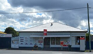
Ubobo is a rural town in the locality of Boyne Valley in the Gladstone Region, Queensland, Australia.

Byellee to Monto Branch Railway was a branch railway that branched off the Boyne Valley west of Gladstone in Queensland, Australia.The Boyne Valley region was predominantly a dairying region and a railway had little justification. However a branch was justified in 1906 on the basis of large traffic in timber, fuel, limestone and flexing ores. Progressively opened between 1910 and 1931 the line branched from the North Coast line at Byellee a short distance west of Gladstone and struck a south-westerly route via Many Peaks and Mungungo to Monto.

<span class="mw-page-title-main">Barney Point, Queensland</span> Suburb of Gladstone, Queensland, Australia

Barney Point is a beachside suburb of Gladstone in the Gladstone Region, Queensland, Australia. In the 2021 census, Barney Point had a population of 1,065 people.

<span class="mw-page-title-main">East End, Queensland</span> Suburb of Gladstone Region, Queensland, Australia

East End is a rural locality in the Gladstone Region, Queensland, Australia. In the 2021 census, East End had a population of 88 people.

West Gladstone is a suburb of Gladstone in the Gladstone Region, Queensland, Australia. In the 2021 census, West Gladstone had a population of 4,844 people.

<span class="mw-page-title-main">Yarwun, Queensland</span> Town in Queensland, Australia

Yarwun is a rural town and coastal locality in the Gladstone Region, Queensland, Australia. In the 2021 census, the locality of Yarwun had a population of 89 people.

<span class="mw-page-title-main">Bororen</span> Town in Queensland, Australia

Bororen is a rural town and locality in the Gladstone Region, Queensland, Australia. In the 2016 census, Bororen had a population of 398 people.

Lowmead is a rural town and locality in the Gladstone Region, Queensland, Australia. In the 2021 census, the locality of Lowmead had a population of 179 people.

Boynedale is a rural locality in the Gladstone Region, Queensland, Australia. In the 2021 census, Boynedale had a population of 13 people.

<span class="mw-page-title-main">Kalpowar</span> Town in Queensland, Australia

Kalpowar is a town in the North Burnett Region and a locality split between the North Burnett Region and the Bundaberg Region, in Queensland, Australia. In the 2016 census, the locality of Kalpowar had a population of 67 people.

<span class="mw-page-title-main">Bancroft, Queensland</span> Suburb of North Burnett Region, Queensland, Australia

Bancroft is a rural locality in the North Burnett Region, Queensland, Australia. In the 2021 census, Bancroft had a population of 98 people.

<span class="mw-page-title-main">Glen Eden, Queensland</span> Suburb of Gladstone, Queensland, Australia

Glen Eden is a suburb of Gladstone in the Gladstone Region, Queensland, Australia. In the 2021 census, Glen Eden had a population of 2,918 people.

<span class="mw-page-title-main">Callemondah</span> Suburb of Gladstone, Queensland, Australia

Callemondah is a coastal suburb of Gladstone in the Gladstone Region, Queensland, Australia. It contains the Port of Gladstone. In the 2021 census, Callemondah had a population of 30 people.

Iveragh is a rural locality in the Gladstone Region, Queensland, Australia.

Beecher is a rural locality in the Gladstone Region, Queensland, Australia. In the 2021 census, Beecher had a population of 876 people.

West Stowe is a rural locality in the Gladstone Region, Queensland, Australia. It is immediately west of the Gladstone urban area and immediately south of the small town of Yarwun. In the 2021 census, West Stowe had a population of 391 people.

Gladstone Harbour is a locality in the Gladstone Region, Queensland, Australia. There are three towns in Gladstone Harbour, all on Facing Island: Northcliffe, Farmers Point and Gatcombe. In the 2021 census, Gladstone Harbour had a population of 24 people.

The Narrows is a coastal locality in the Gladstone Region, Queensland, Australia. In the 2021 census, The Narrows had "no people or a very low population".

<span class="mw-page-title-main">Mount Alma, Queensland</span> Suburb of Gladstone Region, Queensland, Australia

Mount Alma is a rural locality in the Gladstone Region, Queensland, Australia. In the 2021 census, Mount Alma had a population of 59 people.

References

  1. 1 2 3 Australian Bureau of Statistics (28 June 2022). "Byellee (SAL)". 2021 Census QuickStats. Retrieved 28 February 2023. OOjs UI icon edit-ltr-progressive.svg
  2. 1 2 "Byellee – suburb in Gladstone Region (entry 46721)". Queensland Place Names. Queensland Government . Retrieved 10 June 2019.
  3. 1 2 3 4 5 6 7 "Queensland Globe". State of Queensland . Retrieved 30 July 2021.
  4. "Railway stations and sidings - Queensland". Queensland Open Data. Queensland Government. 2 October 2020. Archived from the original on 5 October 2020. Retrieved 5 October 2020.
  5. "Byellee Wetlands". Conservation Volunteers. 31 January 2017. Archived from the original on 31 July 2023. Retrieved 31 July 2023.
  6. Australian Bureau of Statistics (27 June 2017). "Byellee (SSC)". 2016 Census QuickStats. Retrieved 20 October 2018. OOjs UI icon edit-ltr-progressive.svg