Boyne Island Queensland | |||||||||||||||
---|---|---|---|---|---|---|---|---|---|---|---|---|---|---|---|
Coordinates | 23°56′52″S151°21′18″E / 23.9477°S 151.3550°E Coordinates: 23°56′52″S151°21′18″E / 23.9477°S 151.3550°E | ||||||||||||||
Population | 4,835 (2021 census) [1] | ||||||||||||||
• Density | 97.87/km2 (253.49/sq mi) | ||||||||||||||
Postcode(s) | 4680 | ||||||||||||||
Area | 49.4 km2 (19.1 sq mi) | ||||||||||||||
Time zone | AEST (UTC+10:00) | ||||||||||||||
Location |
| ||||||||||||||
LGA(s) | Gladstone Region | ||||||||||||||
State electorate(s) | Gladstone | ||||||||||||||
Federal division(s) | Flynn | ||||||||||||||
|
Boyne Island is a coastal town and locality in the Gladstone Region, Queensland, Australia. [2] [3] In the 2016 census the locality of Boyne Island had a population of 4,760 people. [4]
Boyne Island is 25 kilometres (16 mi) south of Gladstone.
It is located on the west bank of the Boyne River and, is a particular type of island called a holm, an island in a river or an estuary. It is bounded on the eastern side by the Boyne River, for about 4 km and the South Trees Inlet, on the southern, for 9 km, and western sides, for about 8 km Tannum Sands is located on the eastern side of the mouth of the Boyne River spreading southward and is often referred to as Boyne Island's twin town. [5]
The town was named for the Boyne River, which was named by John Oxley in 1823. [2] Originally the island was used for sheep grazing, this was followed by small crops, horticulture, fishing and timber.
St Luke's Anglican Church was built in 1924 on Sayre Crescent. It was designed by Arthur Malpass. It was built from timber. [6] Although the 1924 church building still stands, it was replaced in 1995 by a new brick church building called St Mark's adjacent to the old church building. [7]
Boyne Island State School opened on 27 January 1953. [8]
In the 2016 census, the locality of Boyne Island had a population of 4,760 people. [4]
Boyne Island has a number of heritage-listed sites, including:
Today Boyne Island is primarily a residential centre for the nearby Boyne Island aluminium smelter and Gladstone industries.[ citation needed ]
Australia's largest aluminium smelter, Boyne Smelters Ltd., is located north of the town separated by a buffer zone.[ citation needed ]
Boyne Island State School is a government primary (Prep-6) school for boys and girls at 151 Malpas Street ( 23°57′00″S151°21′23″E / 23.9501°S 151.3564°E ). [12] [13] In 2017, the school had an enrolment of 361 students with 25 teachers (21 full-time equivalent) and 20 non-teaching staff (13 full-time equivalent). [14] In 2018, the school had an enrolment of 384 students with 25 teachers (23 full-time equivalent) and 21 non-teaching staff (13 full-time equivalent). [15] It includes a special education program. [12]
Boyne Island Environmental Education Centre is an Outdoor and Environmental Education Centre at 61 Malpas Street ( 23°57′26″S151°21′01″E / 23.9573°S 151.3502°E ). [12] [16] It offers hands-on activities for students to learn about natural coastal, marine and reef environments of the area and to understand human use of these areas. [17]
There is no secondary school in Boyne Island. The nearest government secondary school is Tannum Sands State High School in neighbouring Tannum Sands to the south-east. [10]
The 13 hole Boyne Island Tannum Sands Golf Course is located in Boyne Island adjacent to the Boyne River, in Jacaranda Drive. [18] Hole 12 in particular is challenging, with out-of-bounds and water hazard in strategic places. [18]
The Gladstone Regional Council operates a public library on Boyne Island at the corner of Wyndham & Hayes Avenue. [19]
St Mark's Anglican Church is on the corner of Malpas Stand and Sayre Crescent ( 23°57′21″S151°21′04″E / 23.955757°S 151.351°E ). [7] [20]
There are a number of parks in the locality, including:
The local rugby league team are the Tannum Sands Seagulls, who despite their name are based in Boyne Island. They compete in the Gladstone District Rugby League competition.
Boyne Island is home to the Boyne Tannum Hookup, which is a large fishing event held on the Labour Day long weekend in May each year. The event is held at Bray Park, which is on the river near the skate park. This event is very popular, with more than 3,000 entrants. [22]
Gladstone is a coastal city in the Gladstone Region, Queensland, Australia. Gladstone has an urban population of 34,703, and together with Boyne Island and Tannum Sands, had an estimated population of 50,317 at August 2021. This urban area covers 246.1 km2 (95.0 sq mi).
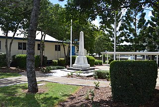
Calliope is a rural town and locality in the Gladstone Region, Queensland, Australia. In the 2021 census, Calliope had a population of 5,263 people.
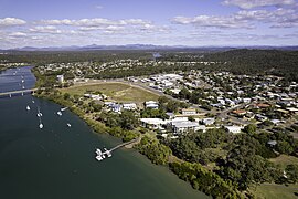
Tannum Sands is a coastal town and locality in the Gladstone Region, Queensland, Australia.
Miriam Vale is a rural town and locality in the Gladstone Region, Queensland, Australia. In the 2016 census, Miriam Vale had a population of 512 people.
The Shire of Calliope was a local government area in the Capricornia region of Queensland, Australia. It was centred on the town of Calliope.
Bangalee is a beachside town on Wild Cattle Island within the locality of Tannum Sands, Gladstone Region, Queensland, Australia.
The Boyne Valley is a rural locality in Gladstone Region, Queensland, Australia. The locality contains four small towns: Nagoorin, Ubobo, Builyan, and Many Peaks. In the 2016 census, Boyne Valley had a population of 358 people. At the 2021 census the population had dropped to 301.
Ubobo is a rural town in the locality of Boyne Valley in the Gladstone Region, Queensland, Australia.
Builyan is a town in Gladstone Region, Central Queensland, Australia. It is one of four small townships within the locality of Boyne Valley along with Nagoorin, Ubobo, and Many Peaks.
Boyne Smelters is located on Boyne Island, Queensland, Australia, approximately 12 km south of the port of Gladstone. The smelter has a production capacity of 545,000 tonnes of aluminium per year. The operating company Boyne Smelters Ltd is 59.4% owned by Rio Tinto Alcan with the balance held by a consortium of Japanese participants including Sumitomo, Marubeni, Mitsubishi and YKK Group. 2011 saw the construction of a new carbon bake furnace to replace the original bake furnace.
The Boyne River is a river located in Central Queensland, Australia.
Benaraby is a rural town and locality in the Gladstone Region, Queensland, Australia.
Newtown is a residential locality in Toowoomba in the Toowoomba Region, Queensland, Australia. In the 2021 census, Newtown had a population of 10,039 people.
Bororen is a rural town and locality in the Gladstone Region, Queensland, Australia. In the 2016 census, Bororen had a population of 398 people.
The Boyne Island Tannum Sands Golf Club is a sports club with a golf course located in Jacaranda Drive, Boyne Island in the Gladstone Region, Queensland, Australia. The club has a 13-hole course adjacent to the Boyne River.
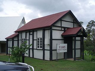
St Luke's Anglican Church is a heritage-listed church at Sayre Crescent, Boyne Island, Gladstone Region, Queensland, Australia. It was designed by Arthur Malpas and built in 1924. It was added to the Queensland Heritage Register on 21 October 1992.
William Wyndham's gravesite is a heritage-listed lone grave at Boyne Island, Gladstone Region, Queensland, Australia. It is also known as Carnym and Wyndhams Farm. It was added to the Queensland Heritage Register on 23 June 2000. It is within the Wyndham Park Heritage Site, accessed between 36 and 38 Alkina Street.
Colosseum is a rural locality in the Gladstone Region, Queensland, Australia. In the 2016 census, Colosseum had a population of 218 people.
Iveragh is a rural locality in the Gladstone Region, Queensland, Australia.
Foreshores is a coastal rural locality in the Gladstone Region, Queensland, Australia. The area is used for farming with some rural residential development.