Foreshores, Queensland

Last updated

Map all coordinates using: OpenStreetMap  
Download coordinates as: KML
Foreshores
Queensland
Australia Queensland location map.svg
Red pog.svg
Foreshores
Coordinates 24°06′30″S151°30′05″E / 24.1083°S 151.5013°E / -24.1083; 151.5013 (Foreshores (centre of locality)) Coordinates: 24°06′30″S151°30′05″E / 24.1083°S 151.5013°E / -24.1083; 151.5013 (Foreshores (centre of locality))
Population142 (SAL 2021) [1]
Postcode(s) 4678
Area236.8 km2 (91.4 sq mi)
Time zone AEST (UTC+10:00)
Location
LGA(s) Gladstone Region
State electorate(s) Burnett
Federal division(s) Flynn
Suburbs around Foreshores:
Tannum Sands Coral Sea Eurimbula
Iveragh Foreshores Rodds Bay
Iveragh Bororen Rodds Bay

Foreshores is a coastal rural locality in the Gladstone Region, Queensland, Australia. [2] The area is used for farming with some rural residential development. [3]

Contents

Geography

The locality is bounded to the north by the Coral Sea. It includes both a mainland component to the south and Hummock Hill Island to the north ( 24°01′03″S151°29′05″E / 24.0176°S 151.4847°E / -24.0176; 151.4847 (Hummock Hill Island) ), [4] which are separated by the Colosseum Inlet ( 24°01′12″S151°26′18″E / 24.02°S 151.4383°E / -24.02; 151.4383 (Colosseum Inlet) ). [5] [6] There are wetlands on both sides of the inlet. [3] The crossing between the mainland and the island is sufficiently shallow that sheep can cross at low tide. [7]

Hummock Hill Island is 9 square miles (23 km2). [8] As the name suggests, the island's main feature is Hummock Hill ( 24°00′46″S151°28′30″E / 24.0129°S 151.4751°E / -24.0129; 151.4751 (Hummock Hill) ), rising 124 metres (407 ft) above sea level. [9] [10]

The Bruce Highway and the North Coast railway line pass through the south-western part of the locality from Bororen to Iveragh. [3]

All parts of the sea within the locality are within the Great Barrier Reef Coast Marine Park. The south-western corner of the locality is within the Castle Tower National Park. [3]

The land along Intrepid Drive is used rural residential purposes. Otherwise the predominant land use is grazing on native vegetation with a small area of plantation timber. As at 2019, there is no land use on Hummock Island. [3]

History

The origin of the locality is not recorded, [2] but presumably relate to its coastal location.

In March 1880, there was a sale of pastoral leases on Hummock Hill Island, which sold for £ 9 per square mile, £ 7 over the upset price. [8]

In 1916, Thomas Farmer was successfully raising sheep on the island. [11] [12]

In 1921, John James Athelstane Murray (1859-1936), son of John Murray, purchased Hummock Hill Island and lived there until his death in 1936. [13]

In the 2016 census, Foreshores had a population of 135 people. [14]

Education

There are no schools in Foreshores. The nearest government primary schools are in Bororen State School in neighbouring Bororen to the south and Benaraby State School in Benaraby to the west. The nearest government secondary school is Tannum Sands State High School in Tannum Sands to the north-west. [3]

Proposed development

In 2019, the Queensland Government conditionally approved a residential and tourist development on Hummock Hill Island. [15] The development will consist of 2,500 residences with 770 of them intended for permanent housing, along with an airstrip, shops and a golf course and is expected to cost $1.2 billion. It includes a bridge from the mainland to the island. [16] The Gladstone Regional Council has opposed the development. [17] [18]

Related Research Articles

<span class="mw-page-title-main">Calliope, Queensland</span> Town in Queensland, Australia

Calliope is a rural town and locality in the Gladstone Region, Queensland, Australia. In the 2016 census, Calliope had a population of 3,438 people.

<span class="mw-page-title-main">Tannum Sands, Queensland</span> Town in Queensland, Australia

Tannum Sands is a coastal town and locality in the Gladstone Region, Queensland, Australia.

<span class="mw-page-title-main">Seventeen Seventy, Queensland</span> Town in Queensland, Australia

Seventeen Seventy, sometimes inaccurately written as 1770 or Town of 1770, is a coastal town and locality in the Gladstone Region, Queensland, Australia. In the 2016 census, the locality of Seventeen Seventy had a population of 69 people.

<span class="mw-page-title-main">Miriam Vale</span> Town in Queensland, Australia

Miriam Vale is a rural town and locality in the Gladstone Region, Queensland, Australia. In the 2016 census, Miriam Vale had a population of 512 people.

<span class="mw-page-title-main">Electoral district of Gladstone</span> State electoral district of Queensland, Australia

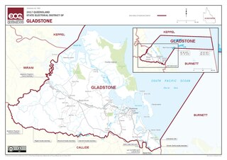
Gladstone is an electoral district of the Legislative Assembly in the Australian state of Queensland.

<span class="mw-page-title-main">Shire of Calliope</span> Local government area in Queensland, Australia

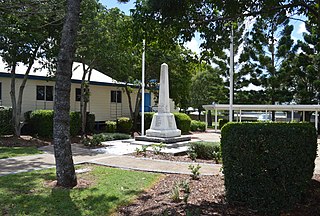
The Shire of Calliope was a local government area in the Capricornia region of Queensland, Australia. It was centred on the town of Calliope.

<span class="mw-page-title-main">Boyne Island, Queensland</span> Town in Queensland, Australia

Boyne Island is a coastal town and locality in the Gladstone Region, Queensland, Australia. In the 2016 census the locality of Boyne Island had a population of 4,760 people.

Bangalee is a beachside town on Wild Cattle Island within the locality of Tannum Sands, Gladstone Region, Queensland, Australia.

<span class="mw-page-title-main">Ubobo</span> Town in Queensland, Australia

Ubobo is a rural town in the locality of Boyne Valley in the Gladstone Region, Queensland, Australia.

<span class="mw-page-title-main">Benaraby</span> Town in Queensland, Australia

Benaraby is a rural town and locality in the Gladstone Region, Queensland, Australia. In the 2016 census the locality of Benaraby had a population of 1,219 people.

<span class="mw-page-title-main">Sea Hill Light</span> Lighthouse

Sea Hill Lighthouse, also known as Sea Hill Point Light or Little Sea Hill Light, is a lighthouse on the northwest point of Curtis Island, Gladstone Region, Queensland, Australia. Its purpose was to mark the east side of the entrance to Keppel Bay, on passage to Fitzroy River and Port Alma. The first lighthouse at the locations was constructed in 1873 or 1876, moved in the 1920s, and is now on display at the Gladstone Maritime Museum. A second lighthouse was constructed in 1895 and its state is unclear.

Eurimbula is a coastal rural locality in the Gladstone Region, Queensland, Australia. In the 2016 census, Eurimbula had a population of 4 people.

<span class="mw-page-title-main">Bororen</span> Suburb of Gladstone Region, Queensland, Australia

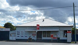
Bororen is a town and locality in the Gladstone Region, Queensland, Australia. In the 2016 census, Bororen had a population of 398 people.

Colosseum is a rural locality in the Gladstone Region, Queensland, Australia. In the 2016 census, Colosseum had a population of 218 people.

<span class="mw-page-title-main">Callemondah</span> Suburb of Gladstone, Queensland, Australia

Callemondah is a coastal suburb of Gladstone in the Gladstone Region, Queensland, Australia. It contains the Port of Gladstone. In the 2016 census Callemondah had a population of 18 people.

Iveragh is a rural locality in the Gladstone Region, Queensland, Australia. In the 2016 census, Iveragh had a population of 140 people.

<span class="mw-page-title-main">South Trees, Queensland</span> Suburb of Gladstone, Queensland, Australia

South Trees is a coastal industrial suburb of Gladstone in the Gladstone Region, Queensland, Australia. In the 2016 census, there were no people living in South Trees.

<span class="mw-page-title-main">Curtis Island, Queensland</span> Suburb of Gladstone Region, Queensland, Australia

Curtis Island is a locality in the Gladstone Region, Queensland, Australia. In the 2016 census, Curtis Island had a population of 323 people.

The Narrows is a coastal locality in the Gladstone Region, Queensland, Australia. In the 2016 census The Narrows had a population of 3 people.

Gladstone–Benaraby Road is a continuous 19.4 kilometres (12.1 mi) road route in the Gladstone region of Queensland, Australia. Much of the route is signed as State Route 58. Gladstone–Benaraby Road is a state-controlled regional road. As part of State Route 58 it provides an alternate route between Benaraby and Mount Larcom. It is also part of the shortest route from Gladstone to the south of the state.

References

  1. Australian Bureau of Statistics (28 June 2022). "Foreshores (Suburb and Locality)". Australian Census 2021 QuickStats. Retrieved 28 June 2022.  OOjs UI icon edit-ltr-progressive.svg
  2. 1 2 "Foreshores – locality in Gladstone Region (entry 49132)". Queensland Place Names. Queensland Government . Retrieved 10 June 2019.
  3. 1 2 3 4 5 6 "Queensland Globe". State of Queensland . Retrieved 22 November 2022.
  4. "Hummock Hill Island – island in Gladstone Region (entry 16447)". Queensland Place Names. Queensland Government . Retrieved 15 October 2019.
  5. "Colosseum Inlet – inlet in Gladstone Regional (entry 7777)". Queensland Place Names. Queensland Government . Retrieved 14 August 2022.
  6. "Colosseum Inlet – inlet in Gladstone Region (entry 7777)". Queensland Place Names. Queensland Government . Retrieved 15 October 2019.
  7. "Advertising". Morning Bulletin . No. 16, 226. Queensland, Australia. 15 August 1916. p. 12. Retrieved 15 October 2019 via National Library of Australia.
  8. 1 2 "Gladstone". The Darling Downs Gazette And General Advertiser . Vol. XX, no. 2969. Queensland, Australia. 19 March 1880. p. 3. Retrieved 15 October 2019 via National Library of Australia.
  9. "Mountain peaks and capes - Queensland". Queensland Open Data. Queensland Government. 12 November 2020. Archived from the original on 25 November 2020. Retrieved 25 November 2020.
  10. "Hummock Hill – mountain in Gladstone Region (entry 16446)". Queensland Place Names. Queensland Government . Retrieved 25 November 2020.
  11. "STOCK STATION & COMMERCIAL [sic]". The Western Champion and General Advertiser for the Central-Western Districts . Vol. XXXVII, no. 1255. Queensland, Australia. 5 February 1916. p. 5. Retrieved 15 October 2019 via National Library of Australia.
  12. "Advertising". The Telegraph . No. 14, 185. Queensland, Australia. 13 May 1918. p. 9. Retrieved 15 October 2019 via National Library of Australia.
  13. "MR J. A. MURRAY". The Central Queensland Herald . Vol. 7, no. 336. Queensland, Australia. 11 June 1936. pp. 24–25. Retrieved 15 October 2019 via National Library of Australia.
  14. Australian Bureau of Statistics (27 June 2017). "Foreshores (SSC)". 2016 Census QuickStats. Retrieved 20 October 2018. OOjs UI icon edit-ltr-progressive.svg
  15. "Hummock Hill Island Development". State Development, Manufacturing, Infrastructure and Planning. Queensland Government. Archived from the original on 15 October 2019. Retrieved 15 October 2019.
  16. "Hummock Hill Island Development". State Development. Queensland Government. 14 September 2020. Retrieved 22 November 2022.
  17. Terzon, Emilia (5 November 2018). "Island 'in the middle of nowhere' gets go-ahead for $1.2b development". ABC News. Retrieved 15 October 2019.
  18. Terzon, Emilia (17 May 2018). "Multi-million-dollar island development knocked back near Gladstone". ABC News. Retrieved 15 October 2019.