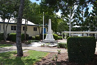
Calliope is a rural town and locality in the Gladstone Region, Queensland, Australia. In the 2021 census, the locality of Calliope had a population of 5,263 people.

Raglan is a rural town and locality in the Gladstone Region, Queensland, Australia. In the 2021 census, the locality of Raglan had a population of 143 people.

East End is a rural locality in the Gladstone Region, Queensland, Australia. In the 2021 census, East End had a population of 88 people.
Bracewell is a rural locality in the Gladstone Region, Queensland, Australia. In the 2021 census, Bracewell had a population of 178 people.
Machine Creek is a rural locality in the Gladstone Region, Queensland, Australia. In the 2021 census, Machine Creek had a population of 131 people.
New Auckland is an urban locality in Gladstone in the Gladstone Region, Queensland, Australia. In the 2021 census, New Auckland had a population of 5,266 people.
Boynedale is a rural locality in the Gladstone Region, Queensland, Australia. In the 2021 census, Boynedale had a population of 13 people.
Berajondo is a rural locality in the Gladstone Region, Queensland, Australia. In the 2021 census, Berajondo had a population of 112 people.
Bukali is a rural locality in the North Burnett Region, Queensland, Australia. In the 2021 census, Bukali had a population of 57 people.
Burua is a rural locality in the Gladstone Region, Queensland, Australia. In the 2021 census, Burua had a population of 849 people.

Tablelands is a rural locality in the Gladstone Region, Queensland, Australia. In the 2021 census, Tablelands had "no people or a very low population".
Iveragh is a rural locality in the Gladstone Region, Queensland, Australia.
Beecher is a rural locality in the Gladstone Region, Queensland, Australia. In the 2021 census, Beecher had a population of 876 people.
West Stowe is a rural locality in the Gladstone Region, Queensland, Australia. It is immediately west of the Gladstone urban area and immediately south of the small town of Yarwun. In the 2021 census, West Stowe had a population of 391 people.
Deepwater is a coastal locality in the Gladstone Region, Queensland, Australia. In the 2021 census, Deepwater had a population of 287 people.
Byellee is an industrial suburb of Gladstone in the Gladstone Region, Queensland, Australia. In the 2021 census, Byellee had "no people or a very low population".

Captain Creek is a rural locality in the Gladstone Region, Queensland, Australia. In the 2021 census, Captain Creek had a population of 452 people.
Darts Creek is a rural locality in the Gladstone Region, Queensland, Australia. In the 2021 census, Darts Creek had a population of 165 people.

Mount Alma is a rural locality in the Gladstone Region, Queensland, Australia. In the 2021 census, Mount Alma had a population of 59 people.
Taunton is a rural locality in the Gladstone Region, Queensland, Australia. In the 2021 census, Taunton had a population of 57 people.
