Pialba

Last updated

Pialba
Hervey Bay,  Queensland
Hervey Bay - Flickr - GregTheBusker.jpg
Aerial view over Pialba
Australia Queensland location map.svg
Red pog.svg
Pialba
Pialba
Coordinates 25°16′50″S152°50′19″E / 25.2805°S 152.8386°E / -25.2805; 152.8386 (Pialba)
Population4,151 (2021 census) [1]
 • Density716/km2 (1,854/sq mi)
Postcode(s) 4655
Area5.8 km2 (2.2 sq mi)
Time zone AEST (UTC+10:00)
Location
LGA(s) Fraser Coast Region
State electorate(s) Hervey Bay
Federal division(s) Hinkler
Localities around Pialba:
Point Vernon Hervey Bay Hervey Bay
Eli Waters Pialba Scarness
Urraween Urraween Kawungan

Pialba is a coastal town and suburb of Hervey Bay in the Fraser Coast Region, Queensland, Australia. [2] [3] It is the central business district of Hervey Bay. In the 2021 census, the suburb of Pialba had a population of 4,151 people. [1]

Contents

Geography

Pialba is a located 294 kilometres (183 mi) north of Brisbane on the southern shore of Hervey Bay. It is the central business district of the town of Hervey Bay.

History

The area was originally known as Point Vernon, until a town was surveyed[ when? ] and named Polson. On 19 March 1931 the town name was changed to Pialba, reflecting the long existing use of that name. [2] [4]

The Hervey Bay railway line from Maryborough to Pialba opened on 18 December 1896. It was used to transport harvested sugarcane to the Maryborough Sugar Mill in addition to daily passenger trains. An extension to Urangan and the Urangan Pier opened on 19 December 1913. As the Pialba railway station was built so close to the beach ( 25°17′02″S152°50′18″E / 25.2840°S 152.8384°E / -25.2840; 152.8384 (Pialba railway station (former)) ), [5] [6] it was not possible to extend the line directly from the Pialba station. A junction was added before the Pialba station and the trains had to reverse out of the station in order to take the junction to Urangan. From 10 June 1929 a railmotor was used to operate the passenger services. [7]

Pialba State School opened on 30 July 1884. [8]

An undenominational church was opened in Pialba on New Year's Day (1 January) 1884 by the Presbyterian minister in Maryborough, Joseph Irvine Knipe. It was erected by German settlers. [9]

Radio broadcasting commenced in the Wide Bay area on Wednesday 14 January 1948 from a transmitter in Piabla under the call sign 4QB which is now ABC Wide Bay. [10]

Hervey Bay State High School opened on 28 January 1964. [8]

Hervey Bay Church of Christ was established in the mid-1970s. However some of the congregation felt that the Church of Christ was adopting an overly liberal interpretation of the Bible and renamed themselves Hervey Bay Bible Church to better reflect their beliefs. Disagreements with the Church of Christ resulted in the congregation leaving the church premises and conducting their services in other premises, initially the QCWA Hall and then later at the Hervey Bay Community Centre. [11]

In June 1985 a group of volunteers established the Women's Information Service which expanded over time to meet a wider range of community needs. It established a community centre in a house at 47 Taylor Street in 1987 and became an incorporated association in 1989. As the number of community programs expanded, larger premises were needed. On 5 December 2011 a new purpose-built Hervey Bay Community Centre was opened at 22 Charles Street. [12]

The Hervey Bay Library opened in 1997 and had a major refurbishment in 2014. [13]

Demographics

In the 2016 census, the suburb of Pialba had a population of 3,678 people. [14]

In the 2021 census, the suburb of Pialba had a population of 4,151 people. [1]

Heritage listings

Pialba has a number of heritage-listed sites, including:

Education

Pialba State School is a government primary (Prep-6) school for boys and girls at Alice Street ( 25°16′45″S152°50′00″E / 25.2793°S 152.8333°E / -25.2793; 152.8333 (Pialba State School) ). [16] [17] In 2017, the school had an enrolment of 456 students with 42 teachers (38 full-time equivalent) and 37 non-teaching staff (26 full-time equivalent). [18] It includes a special education and the Hervey Bay Positive Learning Centre. [16] [19]

Hervey Bay State High School is a government secondary (7-12) school for boys and girls at Beach Road ( 25°16′55″S152°49′56″E / 25.2819°S 152.8322°E / -25.2819; 152.8322 (Hervey Bay State High School) ). [16] [20] In 2017, the school had an enrolment of 1019 students with 88 teachers (83 full-time equivalent) and 43 non-teaching staff (34 full-time equivalent). [18] It includes a special education program. [16] [21]

Amenities

The Fraser Coast Regional Council operate the Hervey Bay library at 161 Old Maryborough Road, Pialba ( 25°17′06″S152°50′13″E / 25.2850°S 152.8370°E / -25.2850; 152.8370 (Hervey Bay Library) ). [22] [23]

The Point Vernon/Pialba branch of the Queensland Country Women's Association meets at the QCWA Rooms at 7 Torquay Road, Pialba ( 25°16′54″S152°50′25″E / 25.2818°S 152.8402°E / -25.2818; 152.8402 (Point Vernon / Pialba CWA) ). [24] [25]

The Hervey Bay Community Centre is at 22 Charles Street ( 25°16′54″S152°50′14″E / 25.2818°S 152.8372°E / -25.2818; 152.8372 (Hervey Bay Community Centre) ). [26]

All Saints Anglican Chapel is at 5 Peters Lane ( 25°16′51″S152°50′26″E / 25.2808°S 152.8406°E / -25.2808; 152.8406 (All Saints Anglican Chapel) ). [27] [28]

Hervey Bay Gospel Church is at 44 Hunter Street ( 25°17′11″S152°50′28″E / 25.2864°S 152.8410°E / -25.2864; 152.8410 (Hervey Bay Gospel Church) ). [29] [30]

Bayside Christian Church is at 18 Neils Street ( 25°17′10″S152°50′44″E / 25.2861°S 152.8455°E / -25.2861; 152.8455 (Bayside Christian Church) ). [31] [32]

Hervey Bay Church of Christ is at 27 Neils Street ( 25°17′14″S152°50′41″E / 25.2872°S 152.8448°E / -25.2872; 152.8448 (Hervey Bay Church of Christ) ). [33] [34]

St Joseph's Catholic Church is at 22 Torquay Road (but accessed from Bryant Street, 25°16′54″S152°50′32″E / 25.2816°S 152.8422°E / -25.2816; 152.8422 (St Joseph's Catholic Church) ). [35] [36] [37]

Hervey Bay Bible Church meets at the Hervey Bay Community Centre each Sunday. [38]

LifeChurch Hervey Bay meets at the Community Centre at 22 Charles Street. [39] It is part of the Wesleyan Methodist Church of Australia. [40]

Related Research Articles

<span class="mw-page-title-main">Maryborough, Queensland</span> City in Queensland, Australia

Maryborough is a city and a suburb in the Fraser Coast Region, Queensland, Australia. In the 2021 census, the suburb of Maryborough had a population of 15,287 people.

<span class="mw-page-title-main">Hervey Bay</span> City in Queensland, Australia

Hervey Bay is a city on the coast of the Fraser Coast Region of Queensland, Australia. The city is situated approximately 290 kilometres (180 mi) or 3½ hours' highway drive north of the state capital, Brisbane. It is located on the bay of the same name open to the Coral Sea between the Queensland mainland and nearby K'gari. The local economy relies on tourism which is based primarily around whale watching in Platypus Bay to the north, ferry access to K'gari, accessible recreational fishing and boating and the natural north facing, calm beaches with wide undeveloped foreshore zones. In October 2019, Hervey Bay was named the First Whale Heritage Site in the world by the World Cetacean Alliance, for its commitment to and practices of sustainable whale and dolphin watching.

<span class="mw-page-title-main">Biggenden</span> Town in Queensland, Australia

Biggenden is a rural town and locality in the North Burnett Region, Queensland, Australia. In the 2021 census, the locality of Biggenden had a population of 788 people.

<span class="mw-page-title-main">Howard, Queensland</span> Town in Queensland, Australia

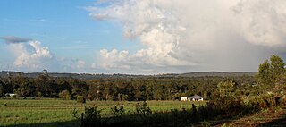
Howard is a rural town and locality in the Fraser Coast Region, Queensland, Australia. It is a southern boundary of the Dundaburra peoples of the Northern Kabi Kabi Isis districts and surrounds. It is located 284 kilometres (176 mi) north of Brisbane and 37 kilometres (23 mi) west of Hervey Bay. In the 2021 census, the locality of Howard had a population of 1,394 people.

<span class="mw-page-title-main">Fraser Coast Region</span> Local government area in Queensland, Australia

The Fraser Coast Region is a local government area in the Wide Bay–Burnett region of Queensland, Australia, about 250 kilometres (160 mi) north of Brisbane, the state capital. It is centred on the twin cities of Hervey Bay and Maryborough and also contains K'gari. It was created in 2008 from a merger of the Cities of Maryborough and Hervey Bay and the Shires of Woocoo and most of Tiaro. The resident population at the 2021 census was 111,032 and the estimated population in 2023 was 117,940.

<span class="mw-page-title-main">Torquay, Queensland</span> Suburb of Hervey Bay, Queensland, Australia

Torquay is a coastal suburb in Hervey Bay in the Fraser Coast Region, Queensland, Australia. In the 2021 census, Torquay had a population of 6,533 people.

<span class="mw-page-title-main">Hervey Bay (Urangan) railway line</span> Former railway line in Queensland, Australia

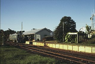
Hervey Bay railway line, sometimes known as Urangan railway line, is a closed railway line in Queensland, Australia. It was opened in 1896 to Pialba and it was extended to Urangan in 1913. It was extended to the end of the Urangan Pier in 1917, along with the opening of the pier. It was closed in 1993.

<span class="mw-page-title-main">Urangan, Queensland</span> Suburb of Hervey Bay, Queensland, Australia

Urangan is a coastal suburb of the city of Hervey Bay in the Fraser Coast Region, Queensland, Australia. In the 2021 census, Urangan had a population of 10,988 people.

Kawungan is a suburb of Hervey Bay in the Fraser Coast Region, Queensland, Australia. In the 2021 census, Kawungan had a population of 5,460 people.

<span class="mw-page-title-main">Tinana, Queensland</span> Town in Queensland, Australia

Tinana is a rural town and locality in the Fraser Coast Region, Queensland, Australia. In the 2021 census, the locality of Tinana had a population of 5,872 people.

<span class="mw-page-title-main">Torbanlea</span> Town in Queensland, Australia

Torbanlea is a rural town and locality in the Fraser Coast Region, Queensland, Australia. In the 2021 census, the locality of Torbanlea had a population of 841 people.

<span class="mw-page-title-main">Burrum Heads</span> Town in Queensland, Australia

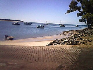
Burrum Heads is a coastal town and locality in the Fraser Coast Region, Queensland, Australia. In the 2021 census, the locality of Burrum Heads had a population of 2,538 people.

Urraween is a suburb of Hervey Bay in the Fraser Coast Region, Queensland, Australia. In the 2021 census, Urraween had a population of 7,951 people.

Granville is a rural locality in the Fraser Coast Region, Queensland, Australia. It is a suburb of Maryborough. In the 2021 census, Granville had a population of 2,532 people.

Nikenbah is a rural town and locality in the Fraser Coast Region, Queensland, Australia. In the 2021 census, the locality of Nikenbah had a population of 1,234 people.

<span class="mw-page-title-main">Bunya Creek, Queensland</span> Suburb of Fraser Coast Region, Queensland, Australia

Bunya Creek is a rural locality in the Fraser Coast Region, Queensland, Australia. In the 2021 census, Bunya Creek had a population of 75 people.

<span class="mw-page-title-main">Craignish, Queensland</span> Suburb of Fraser Coast Region, Queensland, Australia

Craignish is a coastal locality in the Fraser Coast Region, Queensland, Australia. In the 2021 census, Craignish had a population of 2,190 people.

Point Vernon is a coastal suburb in the Fraser Coast Region, Queensland, Australia. In the 2021 census, Point Vernon had a population of 5,718 people.

Scarness is a coastal suburb of Hervey Bay in the Fraser Coast Region, Queensland, Australia. In the 2021 census, Scarness had a population of 3,646 people.

Maryborough–Hervey Bay Road is a continuous 44.9 kilometres (27.9 mi) road route in the Fraser Coast region of Queensland, Australia. The entire route is signed as State Route 57. It is a state-controlled regional road.

References

  1. 1 2 3 Australian Bureau of Statistics (28 June 2022). "Pialba (SAL)". 2021 Census QuickStats. Retrieved 28 February 2023. OOjs UI icon edit-ltr-progressive.svg
  2. 1 2 "Pialba – town in Fraser Coast Region (entry 26589)". Queensland Place Names. Queensland Government . Retrieved 26 January 2020.
  3. "Pialba – suburb in Fraser Coast Region (entry 48347)". Queensland Place Names. Queensland Government . Retrieved 26 January 2020.
  4. "POLSON NOW PIALBA". Maryborough Chronicle, Wide Bay and Burnett Advertiser . Queensland, Australia. 14 April 1931. p. 4. Archived from the original on 22 December 2020. Retrieved 29 February 2020 via Trove.
  5. "Railway stations and sidings - Queensland". Queensland Open Data. Queensland Government. 2 October 2020. Archived from the original on 5 October 2020. Retrieved 5 October 2020.
  6. "Town of Hervey Bay sheet 2 (Town of Pialba)" (Map). Queensland Government. 1980. Archived from the original on 17 December 2021. Retrieved 22 March 2021.
  7. Kerr, John (1990). Triumph of narrow gauge : a history of Queensland Railways. Boolarong Publications. pp. 91–92, 225. ISBN   978-0-86439-102-5.
  8. 1 2 Queensland Family History Society (2010), Queensland schools past and present (Version 1.01 ed.), Queensland Family History Society, ISBN   978-1-921171-26-0
  9. "COUNTRY MAILS". The Brisbane Courier . Vol. XLIV, no. 9, 353. Queensland, Australia. 6 January 1888. p. 6. Retrieved 12 March 2023 via National Library of Australia.
  10. "About Us". ABC Radio. 11 December 2018. Archived from the original on 22 December 2020. Retrieved 22 December 2020.
  11. "Our History". Hervey Bay Bible Church. Archived from the original on 21 March 2021. Retrieved 21 March 2021.
  12. "Our history". Hervey Bay Neighbourhood Centre Inc. Archived from the original on 21 March 2021. Retrieved 21 March 2021.
  13. "Public Libraries Statistical Bulletin 2016-17" (PDF). Public Libraries Connect. State Library of Queensland. November 2017. p. 13. Archived (PDF) from the original on 30 January 2018. Retrieved 30 January 2018.
  14. Australian Bureau of Statistics (27 June 2017). "Pialba (SSC)". 2016 Census QuickStats. Retrieved 20 October 2018. OOjs UI icon edit-ltr-progressive.svg
  15. "650026". Queensland Heritage Register . Queensland Heritage Council. Retrieved 20 February 2018.
  16. 1 2 3 4 "State and non-state school details". Queensland Government. 9 July 2018. Archived from the original on 21 November 2018. Retrieved 21 November 2018.
  17. "Pialba State School". Archived from the original on 29 February 2020. Retrieved 21 November 2018.
  18. 1 2 "ACARA School Profile 2017". Archived from the original on 22 November 2018. Retrieved 22 November 2018.
  19. "Pialba SS - Special Education Program". Archived from the original on 29 February 2020. Retrieved 21 November 2018.
  20. "Hervey Bay State High School". Archived from the original on 29 February 2020. Retrieved 21 November 2018.
  21. "Hervey Bay SHS - Special Education Program". Archived from the original on 29 February 2020. Retrieved 21 November 2018.
  22. "Location and hours". Fraser Coast Regional Council . Archived from the original on 31 January 2018. Retrieved 31 January 2018.
  23. Google (21 March 2021). "Hervey Bay Library (Street View)" (Map). Google Maps . Google. Retrieved 21 March 2021.
  24. "Branch Locations". Queensland Country Women's Association. Archived from the original on 26 December 2018. Retrieved 26 December 2018.
  25. Google (21 March 2021). "7 Torquay Street (Street View)" (Map). Google Maps . Google. Retrieved 21 March 2021.
  26. "Hervey Bay Neighbourhood Centre Inc". Hervey Bay Neighbourhood Centre Inc. Archived from the original on 21 March 2021. Retrieved 21 March 2021.
  27. "All Saints' Anglican Chapel, Pialba". National Redress Scheme . Archived from the original on 21 March 2021. Retrieved 21 March 2021.
  28. Google (21 March 2021). "5 Peters Lane (Street View)" (Map). Google Maps . Google. Retrieved 21 March 2021.
  29. "Home". Hervey Bay Gospel Chapel. Archived from the original on 21 March 2021. Retrieved 21 March 2021.
  30. Google (21 March 2021). "44 Hunter Street, Pialba (Street View)" (Map). Google Maps . Google. Retrieved 21 March 2021.
  31. "Bayside Christian Church". Archived from the original on 21 March 2021. Retrieved 21 March 2021.
  32. Google (21 March 2021). "Bayside Christian Church (Street View)" (Map). Google Maps . Google. Retrieved 21 March 2021.
  33. "Church Of Christ - Hervey Bay". Archived from the original on 21 March 2021. Retrieved 21 March 2021.
  34. Google (21 March 2021). "Hervey Bay Church of Christ (Street View)" (Map). Google Maps . Google. Retrieved 21 March 2021.
  35. Google (22 March 2021). "St Joseph's Catholic Church" (Map). Google Maps . Google. Retrieved 22 March 2021.
  36. "St Joseph's | Hervey Bay Catholic Parish". Archived from the original on 21 March 2021. Retrieved 21 March 2021.
  37. "St Joseph's Church, Pialba". Roman Catholic Archdiocese of Brisbane . Archived from the original on 29 September 2020. Retrieved 21 March 2021.
  38. "Hervey Bay Bible Church". Archived from the original on 21 March 2021. Retrieved 21 March 2021.
  39. "LifeChurch Hervey Bay". Wesleyan Methodist Church Australia. Archived from the original on 24 August 2021. Retrieved 24 August 2021.
  40. "South Queensland". Wesleyan Methodist Church Australia. Archived from the original on 21 August 2021. Retrieved 25 August 2021.