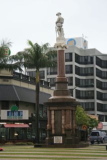
Pialba Memorial Cenotaph

Last updated

Pialba Memorial Cenotaph
650026 cenotaph west side, looking towards Main Street.jpg
West side of the cenotaph
LocationFreedom Park, Main Street, Pialba, Fraser Coast Region, Queensland, Australia
Coordinates 25°16′51″S152°50′20″E / 25.2807°S 152.8389°E / -25.2807; 152.8389 Coordinates: 25°16′51″S152°50′20″E / 25.2807°S 152.8389°E / -25.2807; 152.8389
Design period1919-1930s Interwar period
Built19181921
Architect Philip Oliver Ellard Hawkes
Architectural style(s) Classicism
Official namePialba Memorial Cenotaph
Typestate heritage
Designated6 May 2016
Reference no.650026
TypeMonuments and memorials: Memorial/monument
ThemeCreating social and cultural institutions: Commemorating significant events
BuildersFrederick William Webb
Australia Queensland location map.svg
Red pog.svg
Location of Pialba Memorial Cenotaph in Queensland

Pialba Memorial Cenotaph is a heritage-listed memorial at Freedom Park, Main Street, Pialba, Fraser Coast Region, Queensland, Australia. It was designed by Philip Oliver Ellard Hawkes and built from 1918 to 1921 by Frederick William Webb. It was added to the Queensland Heritage Register on 6 May 2016. [1] It is also known as the Pialba War Memorial and the Hervey Bay War Memorial.

Contents

History

The Pialba Memorial Cenotaph in Freedom Park, Pialba, in Hervey Bay, was unveiled on Sunday 17 July 1921, in honour of the men of the district who left to serve in World War I (WWI), and those who died. Originally sited near the eastern boundary of a railway reserve to the west of Main Street, in the late 1990s the marble pillar on its freestone plinth was moved about 30 metres (98 ft) westwards to its current position, where it was mounted on a modern granite platform, set amongst the paths, grass and trees of Freedom Park. The Pialba Memorial Cenotaph is important in demonstrating Queensland's involvement in a major world event. As a focus for ANZAC Day ceremonies it is highly valued by the Hervey Bay community for its spiritual, symbolic, cultural and social associations. [1]

Pialba is now a suburb of the city of Hervey Bay. European settlement at Hervey Bay began with the establishment of the pastoral run Dalgaroom (16,000 acres (6,500 ha)) in the mid-1850s, and timber-getting commenced in the district in the mid-1860s. Dalgaroom run was reduced to 14,000 acres (5,700 ha) and renamed Toogoom, which was later resumed and surveyed as farming portions from 1870. [2] Farms in the Pialba area grew fruit, maize and potatoes, but they did not prosper until the railway line from Colton railway station (on the North Coast railway line) to Pialba opened on 18 December 1896. [3] Other local industries have included sugar growing and dairy farming. In 1905 Pialba was referred to as "a township and favourite watering place [waterside resort area] for Maryborough", with a population of 292 (1901 census), within a district with a population of 5000. [4] The railway, as well as transporting the produce of local farms, was utilised by seaside excursion trains and special picnic trains, generally run in conjunction with railway employee picnics, originating in Bundaberg, Gympie or Maryborough. [1]

Like all Australian communities, Pialba was impacted by WWI, fought from 1914 to 1918. Of the 330,770 Australians who embarked for overseas service in WWI, 58,961 died and 170,909 were wounded, went missing or became prisoners of war. [5] Even before the end of hostilities, memorials were being erected by Australian communities to honour local people who had served and died. These memorials were a spontaneous and highly visible expression of national grief; substitute graves for the Australians whose bodies lay in battlefield cemeteries in Europe and the Middle East. [6] [1]

Fund-raising for local war memorials was a voluntary community effort, as no State Governments, other than Victoria, made direct grants for local WWI memorials except for the building of halls, hospitals and schools, which were eligible for public money whether or not they were memorials. [7] [1]

WWI memorials took a variety of forms in Australia, including honour boards (from 1915), stone monuments (including obelisks, soldier statues, arches, crosses, columns or urns), tree-lined memorial avenues, memorial parks, and utilitarian structures such as gates, halls and clocks. In Queensland the digger statue was the most popular choice of monument, while the obelisk predominated in southern states. [1]

The argument over whether a war memorial should simply be a monument, or have a utilitarian function, was had all over Australia. Post-WWI, most Australian localities decided on a monumental approach (60%), with only 22% choosing utilitarian buildings (mostly memorial halls) and 18% choosing the compromise position of utilitarian monuments (such as memorial clocks or drinking fountains). After World War II (WWII) the utilitarian form of memorial increased in popularity. [6] [1]

Pialba chose a monument for its war memorial, although some had preferred a memorial School of Arts building. [8] In late 1918 Councillor W Whitaker and Albert Whitford, Member of the Queensland Legislative Assembly, asked the Commissioner for Railways for a suitable site for a memorial "for fallen soldiers", and a site was granted in Station Square, an open area between the Pialba railway station building and Main Street, by August 1918. [9] The location was apt, as many of the men would have departed via the railway station. The Pialba Farewell and Reception Committee (established c.1917) directed the movement, through a memorial committee. The memorial was to consist of a marble monument, with four panels (one on each face of the monument) listing the names of those who enlisted from the district and those who had died. [10] [11] [12] [13] [1]

Pialba's war memorial took several years to realise. The monument's foundation stone, of freestone, was laid by Private Harry Aldridge on 14 December 1918. [14] By this time over £200 had been raised for the memorial by locals, but the delayed arrival of the Italian white marble for the monument's pillar meant the finished memorial was not unveiled until 17 July 1921. [15] During the course of the campaign to erect the monument, the committee responsible met in the local shire hall. [12] [16] [17] The contractor for the monument was Frank William Webb of Maryborough, and the architect was POE Hawkes. [17] [15] [1]

Hawkes, who also designed the Maryborough War Memorial, was born in Wagga Wagga, New South Wales in 1882. He worked as an architect in Wagga Wagga, Perth, Melbourne and Launceston before being employed in a temporary position by the Queensland Government in 1909. He subsequently worked in Maryborough, Bundaberg and Kingaroy, forming a partnership as Hawkes and Palmer in Kingaroy and Maryborough between 1914 and 1917. In 1919 he was employed by the Australian Government as District Adviser, registering as an architect (Qld) in 1930. [18] [1]

The monument's final design included octagonal curbing, and iron posts with wrought iron rails, and these were still extant in a 1950 photo of the monument, which also shows the Pialba Memorial Hall immediately to the north. [19] The base of the marble pillar was inscribed with the words "This stone was erected by the citizens of Pialba and District in honour of the men who served and fell in the great war, 1914-1918", while the panel with the names of the fallen (on the same face of the monument) was headed "In memory of the men who paid the supreme sacrifice in the great war, 1914-1918". The other three panels listed the men "who served at the front". [17] However, articles from August 1918 and July 1921 refer to listing those who had enlisted or volunteered. The names of future wars would later adorn the base of the four sides of the marble pillar: WWII, Korea, Malaya and Borneo, and Vietnam. [1]

At the unveiling ceremony, it was noted that the district had sent 120 men overseas, and 18 had made the "supreme sacrifice"; although the monument currently lists 112 men, of whom 22 died. Mr Huxley Taylor, who had lost two sons at the front, performed the unveiling ceremony, and a German machine gun was also presented to Pialba as a war trophy. [15] [1]

In 1941 the former Pialba Shire Hall was moved to its current location near the cenotaph by the Pialba sub-branch of the RSSAILA for use as a memorial hall. It was located on land purchased from the Commissioner of Railways by the Burrum Shire Council. The hall, which had previously been used on ANZAC Days for gatherings and refreshments, [20] [21] was extended by the RSSAILA. [1]

The use of the land around the cenotaph and memorial hall has changed over time. The last passenger service ran to Pialba station in 1972; the railway reserve was progressively subdivided from 1990; and train services were withdrawn from Pialba in January 1994. [22] [23] The station master's house faced the sea at the north end of the yard (now the northwest corner of Freedom Park) until its removal c.1999. [24] By late 1998 the cenotaph had been moved 30 metres (98 ft) west, as Railway Square was landscaped as part of Freedom Park, which in 2016 covered 0.82 hectares (2.0 acres) of the former railway reserve, including the former railway station building and the memorial hall. [25] [26] The railway station building was also moved westwards, and was rotated 180° to face the cenotaph, which was rededicated on 6 January 1999. A hollow metal world globe with laurel leaves at its base, designed and built by George Pujol, was added to the top of the marble pillar at this time. [1]

A memorial plinth to National Servicemen was dedicated in 2003, north of the cenotaph, and a Light Horse statue and monument was added north of the station building, west of the memorial hall, in 2014 in time for the ANZAC Centenary in 2015. The cenotaph remains the focus of memorial ceremonies. [1]

Description

East side of cenotaph with the former railway station building behind 650026 cenotaph east side, railway station building behind.jpg
East side of cenotaph with the former railway station building behind

The Pialba Memorial Cenotaph stand within a 0.82 hectares (2.0 acres) area known as Freedom Park, on the corner of Main Street and Charles Street in the suburb of Pialba, in Hervey Bay. The site is bounded by residential properties to the west and commercial premises with parking facilities to the south. The open park setting contains level grassed areas, mature shade trees, and various modern landscaping features and memorial structures. [1]

Close-up of the globe added in 1999 650026 detail, with 1990s globe, from SW.jpg
Close-up of the globe added in 1999

Only the cenotaph is considered to be of state heritage significance. The memorial hall is considered to be of local heritage significance. [1]

Memorial Cenotaph

The Pialba Memorial Cenotaph is located at the southern end of Freedom Park and is axially sited at the junction of modern concrete pathways from Main Street and Charles Street. The memorial consists of a decorative white marble pedestal on a light-brown freestone base, centred on a stepped, dark granite platform. [1]

The squat stone base is square in plan, with rock-faced sides and a dressed top with bevelled edges. The pedestal has moulded, stepped sections and decorative leaded panels to each face, listing 22 men from the district who died (on the east panel) and 90 men who served (30 each on the north, west and south panels) in WWI. The decorative cornice features carved lilies and foliage, and is crowned by a plain carved aedicule with triangular pediments. A metal globe, consisting of a welded frame with the continents attached in sheet metal, has been inserted into the top of the aedicule. [1]

Inscriptions to the bottom of  the pedestal commemorate major conflicts including the:

The east face of the shaft bears the inscription: [1]

"THIS STONE WAS ERECTED BY THE CITIZENS OF PIALBA & DISTRICT IN HONOUR OF THE MEN WHO SERVED AND FELL IN THE GREAT WAR. 1914-1919."

The modern granite platform, metal globe and stencilled concrete paths are not heritage-listed. [1]

Landscape Features and Other Structures

Mature trees, including figs (Ficus spp.), are located to the west and north of the cenotaph, and to the north of the hall. The relocated former Pialba railway station building is positioned to the west of the cenotaph. A recently dedicated Light Horse Memorial is situated to the west of the hall and various other modern memorial plaques are positioned throughout Freedom Park. [1]

Heritage listing

Pialba Memorial Cenotaph was listed on the Queensland Heritage Register on 6 May 2016 having satisfied the following criteria. [1]

The place is important in demonstrating the evolution or pattern of Queensland's history.

The Pialba Memorial Cenotaph, unveiled in 1921, is important in demonstrating Queensland's involvement in a major world event. World War I (WWI) memorials are a tribute to those who served, and those who died, from a particular community. As the focus of ANZAC Day and Remembrance Day ceremonies, they are an important element of Queensland's towns and cities and are also important in demonstrating a common pattern of commemoration across Queensland and Australia. [1]

The place is important in demonstrating the principal characteristics of a particular class of cultural places.

The Pialba Memorial Cenotaph is a good example of a well-designed and finely crafted WWI monument, funded by public subscription, and is important in demonstrating the principal characteristics of a WWI memorial. The cenotaph, which includes panels bearing the names of those who served and those that fell, represents the empty grave of those from the district who did not return. Its design and decorative treatments include classical references symbolising sympathy and mourning. [1]

The place has a strong or special association with a particular community or cultural group for social, cultural or spiritual reasons.

The Pialba Memorial Cenotaph, funded by public subscription, has a strong and special association with the people of Hervey Bay. Commemorations at the cenotaph reflect the wider reverence felt for war memorials across Australia. As a focus for ANZAC Day ceremonies the cenotaph is highly valued by the community for its spiritual, symbolic, cultural and social associations. [1]

Related Research Articles

<span class="mw-page-title-main">Maryborough, Queensland</span> City in Queensland, Australia

Maryborough is a city and a suburb in the Fraser Coast Region, Queensland, Australia. At the 2021 Census, Maryborough had a population of 15,287.

<span class="mw-page-title-main">Bundaberg Hummock</span>

The Bundaberg Hummock, also referred to as The Hummock, is an extinct volcano remnant situated in the locality of Qunaba east of Bundaberg, Queensland, Australia. Its official name is Sloping Hummock. The summit of the hill holds both a memorial to Bert Hinkler and the heritage listed Sir Anthony's Rest

<span class="mw-page-title-main">Shire of Woocoo</span> Local government area in Queensland, Australia

The Shire of Woocoo was a local government area located in the Wide Bay–Burnett region of Queensland, Australia, containing the rural residential area to the west of the town of Maryborough, and surrounding countryside. The shire covered an area of 2,007.9 square kilometres (775.3 sq mi), and existed as a local government entity from 1914 until 2008, when it was amalgamated with the City of Maryborough, City of Hervey Bay and the 1st and 2nd divisions of the Shire of Tiaro to form the Fraser Coast Region.

<span class="mw-page-title-main">City of Maryborough (Queensland)</span> Local government area in Queensland, Australia

The City of Maryborough was a local government area located in the Wide Bay–Burnett region of Queensland, Australia, containing the urban locality of Maryborough as well as the southern half of Fraser Island. The City covered an area of 1,233.9 square kilometres (476.4 sq mi), and existed as a local government entity from 1861 until 2008, when it was amalgamated with the City of Hervey Bay, Shire of Woocoo and the 1st and 2nd divisions of the Shire of Tiaro to form the Fraser Coast Region.

<span class="mw-page-title-main">Howard, Queensland</span> Town in Queensland, Australia

Howard is a rural town and locality in the Fraser Coast Region, Queensland, Australia. It is a southern boundary of the Dundaburra peoples of the Northern Kabi Kabi Isis districts and surrounds. In the 2016 census, Howard had a population of 1,359 people. It is located 284 kilometres (176 mi) north of Brisbane and 37 kilometres (23 mi) west of Hervey Bay.

<span class="mw-page-title-main">Torquay, Queensland</span> Suburb of Hervey Bay, Queensland, Australia

Torquay is a coastal suburb in Hervey Bay in the Fraser Coast Region, Queensland, Australia. In the 2016 census, Torquay had a population of 6,316 people.

The Fraser Coast Chronicle is an online newspaper serving the Fraser Coast area in Queensland, Australia. It was started as the Maryborough Chronicle, Wide Bay and Burnett Advertiser.

<span class="mw-page-title-main">Pialba</span> Town in Queensland, Australia

Pialba is a coastal town and suburb of Hervey Bay in the Fraser Coast Region, Queensland, Australia. It is the central business district of Hervey Bay. In the 2016 census, Pialba had a population of 3,678 people.

<span class="mw-page-title-main">Urangan, Queensland</span> Suburb of Hervey Bay, Queensland, Australia

Urangan is a coastal suburb of Hervey Bay in the Fraser Coast Region, Queensland, Australia. In the 2016 census Urangan had a population of 9,764 people.

<span class="mw-page-title-main">Wide Bay–Burnett</span> Region in Queensland, Australia

Wide Bay–Burnett is a region of the Australian state of Queensland, located between 170–400 km (110–250 mi) north of the state capital, Brisbane. The area's population growth has exceeded the state average over the past 20 years, and it is forecast to grow to more than 430,000 by 2031. It is the subject of the Draft Wide Bay–Burnett Regional Plan, which aims to facilitate this growth while protecting over 90% of the region from urban development.

<span class="mw-page-title-main">Port of Maryborough</span> Port in Australia

The Port of Maryborough, Queensland, was opened in 1847 and in 1859 it was declared a port of entry, meaning that overseas and intercolonial vessels could arrive and depart direct, although there appears to have been considerable uncertainty about the name of the port outside Queensland for some years. Customs officials elsewhere and such publications as the Mercantile Navy List frequently called the port "Wide Bay" well into the 1860s.

<span class="mw-page-title-main">Tinana, Queensland</span> Town in Queensland, Australia

Tinana is a rural town and locality in the Fraser Coast Region, Queensland, Australia. In the 2016 census the locality of Tinana had a population of 5,476 people.

<span class="mw-page-title-main">Sandgate War Memorial Park</span> Historic site in Queensland, Australia

Sandgate War Memorial Park is a heritage-listed memorial at 8 Seymour Street, Sandgate, City of Brisbane, Queensland, Australia. It was designed by George Gray Prentice and built from 1923 to 1924 by Lowther & Sons. It was added to the Queensland Heritage Register on 3 October 2005.

<span class="mw-page-title-main">Brooweena War Memorial</span> Historic site in Queensland, Australia

Brooweena War Memorial is a heritage-listed memorial at Smith Crescent, Brooweena, Fraser Coast Region, Queensland, Australia. It was built in 1922 by F W Webb. It was added to the Queensland Heritage Register on 21 October 1992.

<span class="mw-page-title-main">Bundaberg War Memorial</span> Historic site in Queensland, Australia

Bundaberg War Memorial is a heritage-listed memorial at Bourbong Street, Bundaberg Central, Bundaberg, Bundaberg Region, Queensland, Australia. It was designed by Frederic Herbert Faircloth and built from 1920 to 1921 by Anselm & Odling (Sydney). It was added to the Queensland Heritage Register on 21 October 1992.

<span class="mw-page-title-main">Qunaba, Queensland</span> Suburb of Bundaberg Region, Queensland, Australia

Qunaba is a rural locality in the Bundaberg Region, Queensland, Australia. In the 2016 census Qunaba had a population of 793 people.

<span class="mw-page-title-main">World War I Cenotaph, Mackay</span> Historic site in Queensland, Australia

World War I Cenotaph is a heritage-listed memorial at Jubilee Park, Alfred Street, Mackay, Mackay Region, Queensland, Australia. It was designed by Stephen Harvey and built from 1928 to 1929 by Melrose & Fenwick. It is also known as Mackay War Memorial and Jubilee Park. It was added to the Queensland Heritage Register on 21 August 1992.

<span class="mw-page-title-main">Cairns War Memorial</span> Historic site in Queensland, Australia

Cairns War Memorial is a heritage-listed memorial at The Esplanade, Cairns City, Cairns, Cairns Region, Queensland, Australia. It was built in 1925. It was added to the Queensland Heritage Register on 21 October 1992.

Philip Oliver Ellard Hawkes was an architect who practiced in the Wide Bay area of Queensland, Australia, from 1910 to 1942. A number of his works are heritage-listed.

Maryborough–Hervey Bay Road is a continuous 44.9 kilometres (27.9 mi) road route in the Fraser Coast region of Queensland, Australia. The entire route is signed as State Route 57. It is a state-controlled regional road .

References

  1. 1 2 3 4 5 6 7 8 9 10 11 12 13 14 15 16 17 18 19 20 21 22 23 24 25 26 "Pialba Memorial Cenotaph (entry 650026)". Queensland Heritage Register . Queensland Heritage Council. Retrieved 20 February 2018.
  2. "Colonsay Farm (entry 602771)". Queensland Heritage Register . Queensland Heritage Council. Retrieved 20 February 2018.
  3. Although the line was opened in 1896, the Railway Reserve at Pialba was not transferred to the Commissioner of Railways until August 1897 (Department of Natural Resources and Mines, Deed of Grant 22675 (10175185), 1871). An extension to Urangan jetty was opened in 1913 (Andrew Ward and Peter Milner, "Queensland Railway Heritage Places Study: Stage 2, Volume 5". Report for the Queensland Department of Environment and Queensland Rail, April 1997, pp. 129-30).
  4. 'Pugh's Official Almanac and Directory', 1905, p.699.
  5. Embarkation figure is from KS Inglis, Sacred Places: War memorials in the Australian landscape. Miegunyah Press, Victoria, 1998, p.92. Figures for the dead, wounded, missing, or POW are from: http://www.awm.gov.au/encyclopedia/enlistment/ww1/ (accessed 5 August 2013).
  6. 1 2 "Woody Point Memorial Hall (entry 602828)". Queensland Heritage Register . Queensland Heritage Council. Retrieved 20 February 2018.
  7. Inglis, Sacred Places: War memorials in the Australian landscape, p.134.
  8. 'Pialba', Maryborough Chronicle, Wide Bay and Burnett Advertiser, 27 August 1918, p.4.
  9. 'Pialba: soldiers' memorial', Maryborough Chronicle, Wide Bay and Burnett Advertiser, 22 August 1918, p.4.
  10. 'Pialba: soldiers' memorial', Maryborough Chronicle, Wide Bay and Burnett Advertiser, 22 August 1918, p.4
  11. 'Unveiling of memorial at Pialba', Maryborough Chronicle, Wide Bay and Burnett Advertiser, 10 December 1918, p.3
  12. 1 2 'Pialba Memorial Committee', Maryborough Chronicle, Wide Bay and Burnett Advertiser, 22 March 1919, p.7
  13. 'Pialba. Farewell and Reception Committee, memorial stone', Maryborough Chronicle, Wide Bay and Burnett Advertiser, 28 August 1920, p.4.
  14. 'Honouring the Heroes. Pialba's tribute. Laying the memorial foundation stone', Maryborough Chronicle, Wide Bay and Burnett Advertiser, 16 December 1918, p.4.
  15. 1 2 3 "Pialba Honour Stone". Maryborough Chronicle, Wide Bay and Burnett Advertiser . No. 14, 724. Queensland, Australia. 18 July 1921. p. 4. Retrieved 21 February 2018 via National Library of Australia.
  16. 'Pialba. Farewell and Reception Committee, memorial stone', Maryborough Chronicle, Wide Bay and Burnett Advertiser, 28 August 1920, p.4
  17. 1 2 3 'Pialba memorial stone', Maryborough Chronicle, Wide Bay and Burnett Advertiser, 11 May 1921, p.5.
  18. "Queen's Park (entry 600708)". Queensland Heritage Register . Queensland Heritage Council. Retrieved 20 February 2018.
  19. Photo from Hervey Bay Historical Village & Museum, shown on website 'DO NOT REMOVE MEMORIAL HALL - Historical Significance, http://jeanettemaynes.com.au/2015/04/19/do-not-remove-memorial-hall-historical-significance/ (accessed 23 February 2016).
  20. 'ANZAC Day, Service at Pialba', Maryborough Chronicle, Wide Bay and Burnett Advertiser, 30 April 1928, p.2
  21. 'ANZAC Day at Pialba', Maryborough Chronicle, Wide Bay and Burnett Advertiser, 28 April 1938, p.6.
  22. Ward and Milner, "Queensland Railway Heritage Places Study: Stage 2, Volume 5", p.129
  23. Survey Plan RP803656 (1990)
  24. Aerial Photograph QAP5726-137, 10 August 1999
  25. Aerial photograph QAP5433-76 (13 April 1996)
  26. Aerial photograph QAP5699-111 (26 October 1998)

Attribution

CC BY icon-80x15.png This Wikipedia article was originally based on Pialba Memorial Cenotaph , an entry in the Queensland Heritage Register published by the State of Queensland under CC-BY 4.0 AU licence, accessed on 20 February 2018.