Urangan Pier

Last updated

Urangan Pier
Urangan Pier Christmas 2013.JPG
Urangan Pier on Christmas 2013
Coordinates 25°16′46″S152°54′21″E / 25.2794°S 152.9058°E / -25.2794; 152.9058 Coordinates: 25°16′46″S152°54′21″E / 25.2794°S 152.9058°E / -25.2794; 152.9058
CarriesPedestrians
Used to carry trains & produce
Locale Urangan, Queensland, Australia
Characteristics
Design Pier
MaterialTimber
Total length868 metres (2,848 ft)
History
Construction start1913
Construction end1917
Closed1985 (for commercial use)
Location
Urangan Pier

Urangan Pier is a historic pier in Urangan, Hervey Bay, Queensland, Australia.

Contents

It is a former deep-water, cargo-handling facility originally built to facilitate the export of sugar, timber and coal. The pier, served by the extension of the railway line from Pialba, [1] was used for the transfer of cargo between rail and ships. It was built between 1913 and 1917, [2] originally to a length of 1107 metres. The pier was closed in 1985, and 239 metres of it was demolished. However, due to public outcry, 868 metres of the pier was left, and the land was given to the Hervey Bay City Council (now the Fraser Coast Regional Council). [3] [4]

By 2009 the last 220-metre section of the pier had been fully restored, and the original timber pylons had been replaced with steel pylons with a plastic covering. [3]

History

Aerial photograph of Hervey Bay looking north across the Urangan Pier, 1967 Aerial photograph of Hervey Bay looking north, 12 July 1967.jpg
Aerial photograph of Hervey Bay looking north across the Urangan Pier, 1967

The original proposal to establish Urangan as a coal port for the Burrum River mining project did not eventuate due to several factors, mainly because the coal output did not reach original expectations. However, as the Wide Bay area was a chief producer of produce and freight, the Queensland Government made a decision to build a pier at Hervey Bay.

Urangan Seawall, Pier in the background SeawallUranganQLD.jpg
Urangan Seawall, Pier in the background
A plaque at the Urangan Pier; placed in 1999, commemorating the re-opening of the Urangan Pier. UranganPierPlaque.JPG
A plaque at the Urangan Pier; placed in 1999, commemorating the re-opening of the Urangan Pier.

Construction on the Urangan Pier began in 1913. To reach the deep water channel, it was required to extend 1.1 kilometres (0.68 mi) (3690 ft) out to sea. Construction was very slow and finished in 1917. The Urangan railway line also began construction in 1913 and branched off the main railway line at Pialba. This line was extended along the Urangan Pier as it was being constructed. Once it was completed, it served as one of the main ports of Queensland.

Urangan Pier Project Notice UranganPierBoardQLD.jpg
Urangan Pier Project Notice
Urangan Pier in April 2010 Urangan Pier 2010.04 at sunset.jpg
Urangan Pier in April 2010

Sugar was one of the main exports, however had to be transported from as far north as Bundaberg. When the Bundaberg Port was built in 1958, it took over sugar exports and the Urangan pier ceased exporting sugar. [5] Timber, general cargo and produce was still exported until 1960, when Caltex built an oil terminal adjacent to the Pier. Soon after this was built, freight, goods and produce exports were stopped and fuel became the only import from the pier.

After the last ship docked at the Urangan pier in January 1985, Caltex Oil reversed the process of storage, replacing the system of fuel service from Shipping to bulk supply by rail from the Pinkenba and Colmslie port terminals in Brisbane. This, in turn, led to the closure of the pier and the Urangan branch line, as neither had a use any more. At this stage, the pier was in serious need of repairs. A decision was made by the Queensland Government to dismantle the entire pier. Due to large public outcry, rallying and petitions, the demolition of the pier was stopped. In late 1985, the Queensland Government handed the pier to the Hervey Bay City Council. The council pledged to restore the pier, which began in the late 1990s. Restoration included removing the rail tracks from the pier, encasing the wooden pylons with steel, repairing sleepers, repairing hand rails, and repairing lights.

In 1999, the pier was restored to a length of 868 meters. It was officially re-opened by the then-governor of Queensland and the mayor of Hervey Bay, Peter Arnison and Bill Brennan (respectively) on 27 November 1999. [6]

Urangan Pier model

A model of the pier was made by Mr Harry Coxon in 1917, the same year the original pier was constructed. It is a significant artefact in the Hervey Bay Historical Village & Museum's collection. Two new models are on display in the Hervey Bay Tourism Visitor Centre and in the Hervey Bay Whale Watch office at the Boat Harbour Marina. [7]

Urangan Pier Festival

The first Pier Festival was held in 1986 to help raise funds to save Urangan Pier. Since then it has become a popular fishing competition held annually in September. [3]

Pier to Pub Swim

Pier to Pub Ocean Swim Classic is an annual swimming competition held in April since 1999. The 3.4-kilometre (2.1 mi) swim is from Urangan Pier to the jetty opposite the Torquay Hotel, while the 1.6-kilometre (1 mi) short swim, called Splash for Cash, is from the corner of the Esplanade and Alexander Street to the jetty opposite the Torquay Hotel.

See also

Related Research Articles

Maryborough, Queensland City in Queensland, Australia

Maryborough is a city and a suburb in the Fraser Coast Region, Queensland, Australia. As of June 2018 Maryborough had an estimated urban population of 27,282, having grown slightly at an annual average of 0.12% year-on-year over the preceding five years.

Hervey Bay City in Queensland, Australia

Hervey Bay is a small city on the coast of the Fraser Coast Region of Queensland, Australia. The city is situated approximately 290 kilometres (180 mi) or 3½ hours' highway drive north of the state capital, Brisbane. It is located on the bay of the same name open to the Coral Sea between the Queensland mainland and nearby Fraser Island. The local economy relies on tourism which is based primarily around whale watching in Platypus Bay to the north, ferry access to Fraser Island, accessible recreational fishing and boating and the natural north facing, calm beaches with wide undeveloped foreshore zones. In October 2019, Hervey Bay was named the First Whale Heritage Site in the world by the World Cetacean Alliance, for its commitment to and practices of sustainable whale and dolphin watching.

City of Hervey Bay Local government area in Queensland, Australia

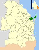
The City of Hervey Bay was a local government area located in the Wide Bay–Burnett region of Queensland, Australia, containing the urban centre of Hervey Bay as well as the northern half of Fraser Island. The City covered an area of 2,356.3 square kilometres (909.8 sq mi), and existed as a local government entity in various forms from 1879 until 2008, when it was amalgamated with the City of Maryborough, Shire of Woocoo and the 1st and 2nd divisions of the Shire of Tiaro to form the Fraser Coast Region.

Torquay, Queensland Suburb of Hervey Bay, Queensland, Australia

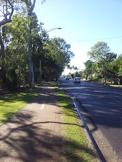
Torquay is a coastal suburb in Hervey Bay in the Fraser Coast Region, Queensland, Australia. In the 2016 census, Torquay had a population of 6,316 people.

Colton railway station is a closed railway station on the North Coast railway line in Queensland. It was the junction for the Urangan railway line that extended from Colton to Takura, Stockyard Creek, Walligan, Nikenbah, Urraween, Kawungan, Pialba, Scarness, Torquay and finally Urangan and the Urangan Pier in Hervey Bay. Much of the Urangan line has now been removed, as has Colton station itself.

Hervey Bay (Urangan) railway line

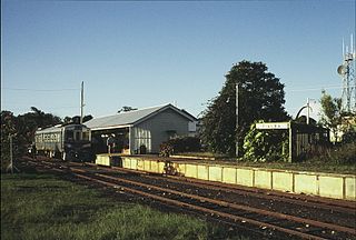
Hervey Bay railway line, sometimes known as Urangan railway line, is a closed railway line in Queensland, Australia. It was opened in 1896 to Pialba and it was extended to Urangan in 1913. It was extended to the end of the Urangan Pier in 1917, along with the opening of the pier. It was closed in 1993.

Pialba Town in Queensland, Australia

Pialba is a coastal town and central business suburb of Hervey Bay in the Fraser Coast Region, Queensland, Australia. In the 2016 census, Pialba had a population of 3,678 people.

Urangan, Queensland Suburb of Hervey Bay, Queensland, Australia

Urangan is a coastal suburb of Hervey Bay in the Fraser Coast Region, Queensland, Australia. In the 2016 census Urangan had a population of 9,764 people.

The Port of Tyne comprises the commercial docks on and around the River Tyne in Tyne and Wear in the northeast of England.

Port of Maryborough Port in Australia

The Port of Maryborough, Queensland, was opened in 1847 and in 1859 it was declared a port of entry, meaning that overseas and intercolonial vessels could arrive and depart direct, although there appears to have been considerable uncertainty about the name of the port outside Queensland for some years. Customs officials elsewhere and such publications as the Mercantile Navy List frequently called the port "Wide Bay" well into the 1860s.

Kawungan, Queensland Suburb of Hervey Bay, Queensland, Australia

Kawungan is a suburb of Hervey Bay in the Fraser Coast Region, Queensland, Australia. In the 2016 census Kawungan had a population of 4,816 people.

Maryborough railway station, Queensland

Maryborough railway station is a heritage-listed railway station at Lennox Street, Maryborough, Fraser Coast Region, Queensland, Australia. It is on the North Coast line serving the city of Maryborough. It was designed by Chief Engineer of the Queensland Railways Department and built from 1878 to 1890 by John Roddam & John Walker. It was added to the Queensland Heritage Register on 21 October 1992.

Woody Island Lighthouses

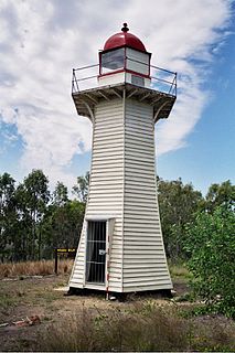
The Woody Island Lighthouses are a pair of heritage-listed lighthouses at Big Woody Island in the Great Sandy Strait, Hervey Bay, Fraser Coast Region, Queensland, Australia. They were built from 1866 to 1870. It was added to the Queensland Heritage Register on 30 March 2001.

Colonsay Farm

Colonsay Farm is a heritage-listed farm at 125 Doolong Road, Kawungan, Fraser Coast Region, Queensland, Australia. It was built in 1909. It is also known as Doolong Farm. It was added to the Queensland Heritage Register on 11 March 2011.

Burnett Bridge

Burnett Bridge is a heritage-listed road bridge crossing the Burnett River from Quay Street, Bundaberg Central to Perry Street, Bundaberg North in Bundaberg, Bundaberg Region, Queensland, Australia. It was designed by Alfred Barton Brady and built in 1900. It is also known as Burnett River Traffic Bridge. It was added to the Queensland Heritage Register on 21 October 1992.

Kennedy Bridge, Bundaberg

Kennedy Bridge is a heritage-listed road bridge on Bourbong Street crossing Bundaberg Creek from Bundaberg Central to Bundaberg East in Bundaberg, Bundaberg Region, Queensland, Australia. It was designed by Alfred Barton Brady and built in 1899. It is also known as Saltwater Creek Road Bridge. It was added to the Queensland Heritage Register on 21 October 1992.

Saltwater Creek Railway Bridge

Saltwater Creek Railway Bridge is a heritage-listed railway bridge over Bundaberg Creek on Quay Street from Bundaberg Central to Bundaberg East in Bundaberg, Bundaberg Region, Queensland, Australia. It was built in 1894 by James Overend. It is also known as Millaquin Bridge. It was added to the Queensland Heritage Register on 21 October 1992.

Nikenbah, Queensland Town in Queensland, Australia

Nikenbah is a rural town and locality in the Fraser Coast Region, Queensland, Australia. In the 2016 census the locality of Nikenbah had a population of 657 people.

Pialba Memorial Cenotaph

Pialba Memorial Cenotaph is a heritage-listed memorial at Freedom Park, Main Street, Pialba, Fraser Coast Region, Queensland, Australia. It was designed by Philip Oliver Ellard Hawkes and built from 1918 to 1921 by Frederick William Webb. It was added to the Queensland Heritage Register on 6 May 2016. It is also known as the Pialba War Memorial and the Hervey Bay War Memorial.

References

  1. "Hervey Bay History". Innovation Herveybay. Archived from the original on 26 September 2009. Retrieved 19 March 2010.
  2. "Urangan Point State School, Block D (entry 601375)". Queensland Heritage Register . Queensland Heritage Council. Retrieved 23 March 2010.
  3. 1 2 3 "Part of Urangan Pier to be Closed". Hervey Bay Gossip. 1 March 2009. Archived from the original on 12 March 2010. Retrieved 19 March 2010.
  4. "Urangan Pier". ozimages. Archived from the original on 8 March 2009. Retrieved 19 March 2010.
  5. "Millaquin Mill". Archived from the original on 12 March 2012. Retrieved 8 November 2015.
  6. Pier history, Hervey Bay, Australia. Retrieved 27 June 2012.
  7. "Urangan Pier Model". ABC. Retrieved 19 March 2010.