Woolooga

Last updated

Map all coordinates using: OpenStreetMap  
Download coordinates as: KML
Woolooga
Queensland
Woolooga.JPG
The main street of Woolooga, showing the general store, with the pub and community hall around the bend.
Australia Queensland location map.svg
Red pog.svg
Woolooga
Coordinates 26°03′06″S152°23′33″E / 26.0516°S 152.3925°E / -26.0516; 152.3925 (Woolooga (town centre)) Coordinates: 26°03′06″S152°23′33″E / 26.0516°S 152.3925°E / -26.0516; 152.3925 (Woolooga (town centre))
Population247 (2016 census) [1]
 • Density0.9876/km2 (2.558/sq mi)
Established1910
Postcode(s) 4570
Area250.1 km2 (96.6 sq mi)
Time zone AEST (UTC+10:00)
Location
LGA(s) Gympie Region
State electorate(s)
Federal division(s) Wide Bay
Localities around Woolooga:
Calgoa Marodian Glen Echo
Mudlo Woolooga Miva
Kilkivan Oakview
Lower Wonga
Sexton

Woolooga is a rural town and locality in the Gympie Region, Queensland, Australia. [2] [3] In the 2016 census the locality of Woolooga had a population of 247 people. [1]

Contents

The town is located in the Gympie Region local government area, 221 kilometres (137 mi) north of the state capital, Brisbane.

Geography

The town is located in the south of the locality. The railway line from Theebine to Nanango passes from the east to the south-west through the locality, but the line is no longer operating. The town was served by the Woolooga railway station ( 26°03′01″S152°23′33″E / 26.05028°S 152.39250°E / -26.05028; 152.39250 (Woolooga railway station) ) while the eastern part was served by the Boowoogum railway station ( 26°01′30″S152°25′16″E / 26.02500°S 152.42111°E / -26.02500; 152.42111 (Boowoogum railway station) ), both of which are now abandoned. [4] [5] [6] [7]

The Wide Bay Creek meanders from the south-west of the locality to the east. [4]

History

Woolooga Memorial Park, 2010 Woolooga Memorial Park.JPG
Woolooga Memorial Park, 2010

Around 1848, John Murray decided to become a pastoral squatter and chose to go to the frontier region of Wide Bay-Burnett in the north of the colony of New South Wales to obtain land. Murray occupied the Walooga run about 40 kilometers west of Gympie. To the south was Widgee Widgee taken up by the Tooth brothers, to the south-west Kilkivan occupied by J D MacTaggart, and to the north-west was Henry Cox Corfield's Gigoomgan run. [8] [9] Even though it appears that Murray lived on Walooga up to 1852, he had never met the conditions to hold the rights to the property and in late 1850 it was declared a vacant run. [10] [11] Murray went on to serve with the Australian native police, a paramilitary force, for nearly twenty years. [12]

In 1850 tenders were called for the lease of Crown Lands known as Walooga. The boundaries of the pastoral run were described as:- "To start from Walooga Hut on Kilkivan Creek, west to Mount Warren 2 miles (3.2  km ); from thence by a line south 2 miles (3.2 km) to a tree marked J; from thence by a line east 12½ miles to a tree marked M; from thence north by a line to the creek 2 miles (3.2 km); and from thence to the starting point (Walooga Hut) 10½ miles, it being understood that Kilkivan Creek forms the northern boundary." [11] William Powell became the licensee for the pastoral run of Walooga in May 1854. [13] In 1858 the license for Walooga was transferred to Robert Tooth, who had the license for several adjoining runs severally known as Widgee Widgee. [14] [15] Land use at this time was large-scale wool growing. [15] By 1868 Walooga was described as a vacated sheep station, and in 1869 these runs were transferred to the Bank of New South Wales. [16] [17] In August that year 120,300 acres of the runs that comprised Widgee station were resumed for the purpose of selection. [18] [19]

Woolooga was a site of frontier war in the 1850s and 1860s. [10] [20]

Robert Stuart Lord and his brother Alfred Percy Lord won land in selection ballots in 1875 and 1876. [21] [22] Together with Henry E King they then he Woolooga Estate

Woolooga railway station was named in 1886 by the Queensland Railways Department and subsequently became used as the town and locality name. It is reported to be an Aboriginal word from the Kabi language with wului meaning smoke and tha meaning ground/place. [2] [3]

Aerial view of Woolooga looking east, 2016 Woolooga aerial.jpg
Aerial view of Woolooga looking east, 2016

Woolooga State School opened on 20 January 1913. [23]

Wonga Upper Provisional School opened on 13 July 1914. On 1 December 1914 it became Wonga Upper State School. It closed in 1959. [23]

The Woolooga Memorial Park commemorates those who served in war. It is located in Thomas Street. [24]

At the 2006 census, Woolooga and the surrounding rural area had a population of 319. [25]

Woolooga was affected by the 2010–2011 Queensland floods. A 2-metre (6.6 ft) wall of water rushed through the town, inundating the public hall and the pub. [26] The general store was also severely damaged by the flood. [27]

In the 2011 census, Woolooga had a population of 274 people. [28]

In the 2016 census the locality of Woolooga had a population of 247 people. [1]

Heritage listings

Woolooga has a number of heritage-listed sites, including:

Education

Woolooga State School is a government primary (Prep-6) school for boys and girls at Edwards Road ( 26°02′54″S152°23′45″E / 26.0483°S 152.3958°E / -26.0483; 152.3958 (Woolooga State School) ). [30] [31] In 2018, the school had an enrolment of 14 students with 2 teachers and 5 non-teaching staff (2 full-time equivalent). [32]

There is no secondary school. The nearest government secondary schools are Kilkivan State School (to Year 10) in neighbouring Kilkivan to the south-west and James Nash State High School in Gympie to the south-east. [4]

Amenities

Woolooga Memorial Park is in Thomas Street (also known as the Bauple Woolooga Road) at the corner of Booker Street ( 26°03′11″S152°23′34″E / 26.0531°S 152.3927°E / -26.0531; 152.3927 (Memorial Park) ). [33] It commemorates those who have served Australia during times of war with their names listed on a brass Honour Roll. [34] [35]

Related Research Articles

<span class="mw-page-title-main">Landsborough, Queensland</span> Town in Queensland, Australia

Landsborough is a town and a locality in the Sunshine Coast Region, Queensland, Australia. At the 2021 census, Landsborough had a population of 4,446 people.

<span class="mw-page-title-main">Kilkivan, Queensland</span> Town in Queensland, Australia

Kilkivan is a town and locality in the Gympie Region of Queensland, Australia. At the 2016 census, Kilkivan had a population of 713.

<span class="mw-page-title-main">Goomeri</span> Town in Queensland, Australia

Goomeri is a rural town and locality in the Gympie Region, Queensland, Australia. In the 2016 census, the locality of Goomeri had a population of 664 people.

<span class="mw-page-title-main">Shire of Kilkivan</span> Local government area in Queensland, Australia

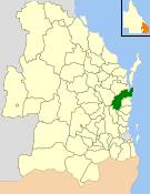
The Shire of Kilkivan was a local government area about 180 kilometres (112 mi) north-northwest of Brisbane, the state capital of Queensland, Australia. The shire covered an area of 3,263.4 square kilometres (1,260.0 sq mi), and existed from 1886 until its merger with several other local government areas to form the Gympie Region on 15 March 2008.

<span class="mw-page-title-main">Cooran, Queensland</span> Town in Queensland, Australia

Cooran is a rural hinterland town and locality in the Shire of Noosa, Queensland, Australia. In the 2016 census the locality of Cooran had a population of 1,624 people.

<span class="mw-page-title-main">Shire of Cooloola</span> Local government area in Queensland, Australia

The Shire of Cooloola was a local government area located about 170 kilometres (106 mi) north of Brisbane – the state capital of Queensland, Australia. The shire covered an area of 2,968.8 square kilometres (1,146.3 sq mi), and was the product of a merger in 1993 between the City of Gympie and the Shire of Widgee, which had both existed since 1879–1880. It merged with several other LGAs to form the Gympie Region on 15 March 2008.

<span class="mw-page-title-main">Gympie Region</span> Local government area in Queensland, Australia

The Gympie Region is a local government area in the Wide Bay–Burnett region of Queensland, Australia, about 170 kilometres (110 mi) north of Brisbane, the state capital. It is between the Sunshine Coast and Hervey Bay and centred on the town of Gympie. It was created in 2008 from a merger of the Shires of Cooloola and Kilkivan and part of the Shire of Tiaro.

Victory Heights is a rural residential locality in the Gympie Region, Queensland, Australia. In the 2016 census Victory Heights had a population of 555 people.

Tamaree is a rural residential locality in the Gympie Region, Queensland, Australia. In the 2016 census Tamaree had a population of 880 people.

<span class="mw-page-title-main">Tingoora</span> Town in Queensland, Australia

Tingoora is a rural town and a locality in the South Burnett Region, Queensland, Australia. In the 2016 census, Tingoora had a population of 273.

<span class="mw-page-title-main">Theebine</span> Town in Queensland, Australia

Theebine is a small town and locality split between the Gympie Region and the Fraser Coast Region, both in Queensland, Australia.

<span class="mw-page-title-main">Gunalda</span> Town in Queensland, Australia

Gunalda is a rural town in the Gympie Region and a locality split between Gympie Region and Fraser Coast Region in Queensland, Australia. In the 2016 census, the locality of Gunalda had a population of 392 people.

<span class="mw-page-title-main">Miva, Queensland</span> Town in Queensland, Australia

Miva is a locality split between the Gympie Region and the Fraser Coast Region in Queensland, Australia. > In the 2016 census Miva had a population of 57 people.

<span class="mw-page-title-main">Widgee</span> Suburb of Gympie Region, Queensland, Australia

Widgee is a rural locality in the Gympie Region, Queensland, Australia. In the 2016 census, Widgee had a population of 794 people.

<span class="mw-page-title-main">City of Gympie</span>

The City of Gympie is a former local government area in the south-east of Queensland, Australia, responsible for governing Gympie.

The Shire of Widgee is a former local government area in the Wide Bay–Burnett area of Queensland, Australia. It was located in the rural areas around the town of Gympie but did not include the town itself, which was always in a separate local government area. The administrative offices of the Shire of Widgee were located in Gympie.

Lower Wonga is a rural locality in the Gympie Region, Queensland, Australia. In the 2016 census Lower Wonga had a population of 344 people.

Bells Bridge is a rural locality in the Gympie Region, Queensland, Australia. In the 2016 census Bells Bridge had a population of 197 people.

<span class="mw-page-title-main">Cinnabar, Queensland</span> Suburb of Gympie Region, Queensland, Australia

Cinnabar is a rural locality in the Gympie Region, Queensland, Australia. In the 2016 census, Cinnabar had a population of 72 people.

Kinbombi is a rural town and locality in the Gympie Region, Queensland, Australia. In the 2016 census, the locality of Kinbombi had a population of 37 people.

References

  1. 1 2 3 Australian Bureau of Statistics (27 June 2017). "Woolooga (SSC)". 2016 Census QuickStats. Retrieved 20 October 2018. OOjs UI icon edit-ltr-progressive.svg
  2. 1 2 "Woolooga – town in Gympie Region (entry 38055)". Queensland Place Names. Queensland Government . Retrieved 27 December 2020.
  3. 1 2 "Woolooga – locality in Gympie Region (entry 46403)". Queensland Place Names. Queensland Government . Retrieved 27 December 2020.
  4. 1 2 3 "Queensland Globe". State of Queensland . Retrieved 24 March 2021.
  5. "Woolooga – railway station (entry 38056)". Queensland Place Names. Queensland Government . Retrieved 31 August 2016.
  6. "Boowoogum – railway station (entry 3842)". Queensland Place Names. Queensland Government . Retrieved 31 August 2016.
  7. "Railway stations and sidings - Queensland". Queensland Open Data. Queensland Government. 2 October 2020. Archived from the original on 5 October 2020. Retrieved 5 October 2020.
  8. Logan, Dulcie (1988). Where Two Rivers Run: A History of the Kilkivan Shire. Kilkivan: Kilkivan Shire Council. p. 55.
  9. Pedley, Ian (1979). Winds of Change: One Hundred Years in Widgee Shire. Gympie: Widgee Shire Council. pp. 16–21.
  10. 1 2 "ORIGINAL CORRESPONDENCE". The Sydney Morning Herald . Vol. XXX, no. 4280. New South Wales, Australia. 3 February 1851. p. 2. Retrieved 5 November 2022 via National Library of Australia.
  11. 1 2 "FORFEITED AND VACATED RUNS". New South Wales Government Gazette . No. 108. New South Wales, Australia. 11 September 1850. p. 1412. Retrieved 5 November 2022 via National Library of Australia.
  12. Richards, Jonathan (2005). ""A Question of Necessity" : The Native Police in Queensland" (PDF). Griffith University . p. 94.
  13. "CROWN LANDS BEYOND THE SETTLED DISTRICTS". New South Wales Government Gazette . No. 68. New South Wales, Australia. 6 June 1854. p. 1196. Retrieved 5 November 2022 via National Library of Australia.
  14. "TRANSFER OF RUNS". The Moreton Bay Courier . Vol. XII, no. 650. Queensland, Australia. 19 May 1858. p. 3. Retrieved 5 November 2022 via National Library of Australia.
  15. 1 2 Dale, J. D. (27 July 1978). "WIDGEE - IN THE DAYS OF WIDGEE STATION" (PDF). University of Queensland. p. 112.
  16. "THE ROUTH TO THE GYMPIE DIGGINGS". The Darling Downs Gazette And General Advertiser . Vol. X, no. 678. Queensland, Australia. 9 January 1868. p. 3. Retrieved 5 November 2022 via National Library of Australia.
  17. "LOCAL AND GENERAL NEWS". Gympie Times And Mary River Mining Gazette . Vol. I, no. 110. Queensland, Australia. 14 January 1869. p. 2. Retrieved 5 November 2022 via National Library of Australia.
  18. "Advertising". Gympie Times And Mary River Mining Gazette . Vol. II, no. 184. Queensland, Australia. 28 August 1869. p. 2. Retrieved 5 November 2022 via National Library of Australia.
  19. Dale, J. D. (27 July 1978). "WIDGEE - IN THE DAYS OF WIDGEE STATION" (PDF). University of Queensland. p. 116.
  20. Dale, J. D. (27 July 1978). "WIDGEE - IN THE DAYS OF WIDGEE STATION" (PDF). Universty of Queensland. pp. 114–115. Retrieved 5 November 2022.
  21. "GYMPIE LAND COURT". The Queenslander . Vol. X, no. 13. Queensland, Australia. 13 November 1875. p. 25. Retrieved 6 November 2022 via National Library of Australia.
  22. "Intercolonial". Maryborough Chronicle, Wide Bay And Burnett Advertiser . No. 1912. Queensland, Australia. 14 November 1876. p. 4. Retrieved 6 November 2022 via National Library of Australia.
  23. 1 2 Queensland Family History Society (2010), Queensland schools past and present (Version 1.01 ed.), Queensland Family History Society, ISBN   978-1-921171-26-0
  24. "Woolooga Memorial Park". Monument Australia. Archived from the original on 7 April 2014. Retrieved 6 April 2014.
  25. Australian Bureau of Statistics (25 October 2007). "Woolooga (Kilkivan Shire) (State Suburb)". 2006 Census QuickStats. Retrieved 19 January 2011.
  26. "Western areas hit with record rain". Gympie Times. 9 January 2011. Archived from the original on 14 January 2011. Retrieved 19 January 2011.
  27. Harch, Christine (19 January 2011). "Spirit not dampened by floods". Gympie Times. Archived from the original on 20 January 2011. Retrieved 19 January 2011.
  28. Australian Bureau of Statistics (31 October 2012). "Woolooga (SSC)". 2011 Census QuickStats. Retrieved 31 August 2016. OOjs UI icon edit-ltr-progressive.svg
  29. "Woolooga Rail Bridge (entry 600645)". Queensland Heritage Register . Queensland Heritage Council. Retrieved 8 July 2013.
  30. "State and non-state school details". Queensland Government. 9 July 2018. Archived from the original on 21 November 2018. Retrieved 21 November 2018.
  31. "Woolooga State School". Archived from the original on 14 March 2021. Retrieved 24 March 2021.
  32. "ACARA School Profile 2018". Australian Curriculum, Assessment and Reporting Authority. Archived from the original on 27 August 2020. Retrieved 28 January 2020.
  33. "Land for public recreation - Queensland". Queensland Open Data. Queensland Government. 20 November 2020. Archived from the original on 22 November 2020. Retrieved 22 November 2020.
  34. "Woolooga Memorial Park". Monument Australia. Archived from the original on 5 January 2015. Retrieved 24 March 2021.
  35. "Woolooga and District War Memorial". Queensland War Memorials Register. 23 June 2014. Archived from the original on 9 March 2020. Retrieved 24 March 2021.

Commons-logo.svg Media related to Woolooga, Queensland at Wikimedia Commons