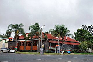
Boonara, Queensland

Last updated

Map all coordinates using: OpenStreetMap  
Download coordinates as: KML  ·  GPX
Boonara
Queensland
Entrance to Boonara Homestead, 2015 01.jpg
Entrance to Boonara Homestead, 2015
Australia Queensland location map.svg
Red pog.svg
Boonara
Coordinates 26°04′44″S152°01′34″E / 26.0788°S 152.0261°E / -26.0788; 152.0261 (Boonara (centre of locality))
Population74 (2016 census) [1]
 • Density0.852/km2 (2.206/sq mi)
Established1877
Postcode(s) 4601
Area86.9 km2 (33.6 sq mi)
Time zone AEST (UTC+10:00)
Location
LGA(s) Gympie Region
State electorate(s) Nanango
Federal Division(s) Wide Bay
Suburbs around Boonara:
Cobbs Hill Tansey Tansey
Crownthorpe Boonara Cinnabar
Crownthorpe Goomeribong Goomeri

Boonara is a rural locality in the Gympie Region, Queensland, Australia. [2] In the 2016 census, Boonara had a population of 74 people. [1]

Contents

History

Boonara Homestead, 2015 Boonara Homestead, 2015.jpg
Boonara Homestead, 2015

The Boonara pastoral station was established in 1862.

Land in Boonara was open for selection on 17 April 1877; 47 square miles (120 km2) were available. [3]

Boonara Provisional School was opened on 20 January 1902. In 1909 became Boonara State School. It closed on 22 May 1964. [4] It was on the Burnett Highway just to the south of the homestead (approx 26°05′19″S152°03′21″E / 26.0886°S 152.0559°E / -26.0886; 152.0559 (Boonara State School (site)) ). [5]

St David's Anglican Church, 2015 St David's Anglican Church, Boonara, 2015.jpg
St David's Anglican Church, 2015

St David's Anglican Church opened in 1914. [6]

In the 2016 census, Boonara had a population of 74 people. [1]

Heritage listings

The Boonara Homestead at 1791 Burnett Highway ( 26°05′06″S152°03′06″E / 26.0849°S 152.0517°E / -26.0849; 152.0517 (Boonara Homestead) ) is listed on the Gympie Heritage Register. [7]

Amenities

Boonara cemetery, 2015 Boonara cemetery, 2015.jpg
Boonara cemetery, 2015

St David's Anglican Church is at 7179 Burnett Highway ( 26°05′06″S152°03′13″E / 26.0850°S 152.0537°E / -26.0850; 152.0537 (St David's Anglican Church) ). [8] There is a cemetery behind the church. [9]

Related Research Articles

Maryborough, Queensland City in Queensland, Australia

Maryborough is a city and a suburb in the Fraser Coast Region, Queensland, Australia. As of June 2018 Maryborough had an estimated urban population of 27,282, having grown slightly at an annual average of 0.12% year-on-year over the preceding five years.

Gympie Town in Queensland, Australia

Gympie is a town and a locality in the Gympie Region, Queensland, Australia. Located in the Wide Bay-Burnett district, Gympie is about 160 kilometres (100 mi) north of the state capital, Brisbane. The city lies on the Mary River, which floods the town occasionally. Gympie is the administrative centre for the Gympie Region area. As at June 2018 Gympie had a population of 21,599.

Rathdowney, Queensland Town in Queensland, Australia

Rathdowney is a rural town and locality in the Scenic Rim Region, Queensland, Australia. In the 2016 census, Rathdowney had a population of 308 people.

Eidsvold, Queensland Town in Queensland, Australia

Eidsvold is a rural town and locality in the North Burnett Region, Queensland, Australia. The town is the self-proclaimed Beef Capital of the Burnett and is a hub for the regional cattle industry. In the 2016 census, Eidsvold had a population of 574 people.

Glass House Mountains, Queensland Town in Queensland, Australia

Glass House Mountains is a hinterland town and locality of the Sunshine Coast Region, Queensland, Australia, named after the famous Glass House Mountains of the area. Colloquially it is often known simply as "Glasshouse". At the 2016 census, Glass House Mountains had a population of 5,065.

Murgon Town in Queensland, Australia

Murgon is a rural town and locality in the South Burnett Region, Queensland, Australia. It is situated on the Bunya Highway 270 kilometres (170 mi) north-west of the state capital, Brisbane. At the 2016 Australian Census, the town recorded a population of 2,378.

Rainbow Beach, Queensland Town in Queensland, Australia

Rainbow Beach is a coastal rural town and locality in the Gympie Region, Queensland, Australia. In the 2016 census, Rainbow Beach had a population of 1,249 people.

Mulgildie Town in Queensland, Australia

Mulgildie is a town and a locality in the North Burnett Region, Queensland, Australia. In the 2016 census, Mulgildie had a population of 174 people.

Wondai Town in Queensland, Australia

Wondai is a rural town and locality in the South Burnett Region, Queensland, Australia. In the 2016 census, Wondai had a population of 1,973 people.

Kilkivan, Queensland Town in Queensland, Australia

Kilkivan is a town and locality in the Gympie Region of Queensland, Australia. At the 2016 census, Kilkivan had a population of 713. Rossmore is a neighbourhood within the locality to the south-west of the town of Kilkivan.

Goomeri Town in Queensland, Australia

Goomeri is a town and locality in the Gympie Region, Queensland, Australia. In the 2016 census, Goomeri had a population of 664 people.

Eumundi, Queensland Town in Queensland, Australia

Eumundi is a small town and locality in the Sunshine Coast hinterland in the Sunshine Coast Region, Queensland, Australia. Eumundi is very popular on the coast for its bi-weekly farmers' markets. The marketplace is full of locally-made produce, which has made Eumundi and the surrounding area a haven for small businesses.

Coominya, Queensland Town in Queensland, Australia

Coominya is a town and locality in the Somerset Region in South East Queensland, Australia. The town is located 83 kilometres (52 mi) west of the state capital, Brisbane and approximately 2 kilometres (1.2 mi) from Wivenhoe Dam. In the 2016 census, Coominya had a population of 1,200 people.

Howard, Queensland Town in Queensland, Australia

Howard is a rural town and locality in the Fraser Coast Region, Queensland, Australia. In the 2016 census, Howard had a population of 1,359 people. It is located 284 kilometres (176 mi) north of Brisbane and 37 kilometres (23 mi) west of Hervey Bay.

Lawnton, Queensland Suburb of Moreton Bay Region, Queensland, Australia

Lawnton is a suburb in the Moreton Bay Region, Queensland, Australia.

Imbil Town in Queensland, Australia

Imbil is a rural town and locality in the Gympie Region, Queensland, Australia. In the 2016 census, Imbil had a population of 924 people.

Gunalda Town in Queensland, Australia

Gunalda is a town in the Gympie Region and a locality split between Gympie Region and Fraser Coast Region in Queensland, Australia. In the 2016 census, Gunalda had a population of 392 people.

Wolvi, Queensland Suburb of Gympie Region, Queensland, Australia

Wolvi is a rural locality in the Gympie Region, Queensland, Australia. In the 2016 census, Wolvi had a population of 467 people.

Mondure Town in Queensland, Australia

Mondure is a rural town and locality in the South Burnett Region, Queensland, Australia. In the 2016 census, Mondure had a population of 100 people.

Munna Creek Suburb of Fraser Coast Region, Queensland, Australia

Munna Creek is a locality split between the Fraser Coast Region and the Gympie Region, in Queensland, Australia. In the 2016 census, Munna Creek had a population of 23 people.

References

  1. 1 2 3 Australian Bureau of Statistics (27 June 2017). "Boonara (SSC)". 2016 Census QuickStats. Retrieved 20 October 2018. OOjs UI icon edit-ltr-progressive.svg
  2. "Boonara - locality in Gympie Region (entry 46308)". Queensland Place Names. Queensland Government . Retrieved 16 September 2020.
  3. "Proclamations under the New Land Acts". The Brisbane Courier . Queensland, Australia. 2 March 1877. p. 3. Archived from the original on 27 August 2020. Retrieved 19 February 2020 via Trove.
  4. "Agency ID 6236, Boonara State School". Queensland State Archives . Retrieved 16 September 2020.
  5. "Kilkivan" (Map). Queensland Government. 1943. Archived from the original on 15 September 2020. Retrieved 26 September 2019.
  6. "Year Book" (PDF). Anglican Archdiocese of Brisbane. 2019. p. 132. Archived (PDF) from the original on 15 September 2020. Retrieved 15 September 2020.
  7. "Local heritage places" (PDF). Gympie Regional Council . p. 4. Archived (PDF) from the original on 16 September 2020. Retrieved 16 September 2020.
  8. "St David's Anglican Church". Churches Australia. Archived from the original on 16 September 2020. Retrieved 15 September 2020.
  9. "Cemeteries". Gympie Regional Council. Archived from the original on 21 June 2019. Retrieved 15 September 2020.

Commons-logo.svg Media related to Boonara, Queensland at Wikimedia Commons