Cinnabar, Queensland

Last updated

Cinnabar
Queensland
John Lennox and men taking steam engines to the mercury mines at Cinnebar, Queensland, circa 1935.jpg
John Lennox and men taking steam engines to the mercury mines at Cinnabar, circa 1935
Australia Queensland location map.svg
Red pog.svg
Cinnabar
Coordinates 26°08′29″S152°10′59″E / 26.1413°S 152.1830°E / -26.1413; 152.1830 (Cinnabar (centre of locality))
Population72 (2016 census) [1]
 • Density0.472/km2 (1.221/sq mi)
Postcode(s) 4600
Area152.7 km2 (59.0 sq mi)
Time zone AEST (UTC+10:00)
Location
LGA(s) Gympie Region
State electorate(s) Nanango
Federal division(s) Wide Bay
Suburbs around Cinnabar:
Boonara Tansey Kilkivan
Goomeri Cinnabar Black Snake
Kinbombi Manumbar Wrattens Forest

Cinnabar is a rural locality in the Gympie Region, Queensland, Australia. [2] In the 2016 census, Cinnabar had a population of 72 people. [1]

Contents

Geography

Woman feeding sheep at Cinnabar, circa 1925 Woman feeding sheep at Cinnabar, circa 1925.jpg
Woman feeding sheep at Cinnabar, circa 1925

The Wide Bay Highway enters the location from the north-west (Kilkivan) and exits to the south-west (Kinbombi). [3]

The Breezer is a mountain in the south-west of the locality ( 26°11′45″S152°10′37″E / 26.1958°S 152.1770°E / -26.1958; 152.1770 (The Breezer) ) which rises to 466 metres (1,529 ft) above sea level. [4] [5]

Cinnabar State Forest is a 388.5-hectare (960-acre) forest reserve in the north-west of the locality ( 26°06′32″S152°06′04″E / 26.109°S 152.101°E / -26.109; 152.101 (Cinnabar State Forest) ). Apart from the state forest, the land use is predominantly grazing on native vegetation with some crop-growing around the creeks. [3]

History

Bullock team at Cinnabar, circa 1900 Bullock team at Cinnabar in the Kilkivan district, circa 1900.jpg
Bullock team at Cinnabar, circa 1900

In 1872, the mineral cinnabar (a sulphide of mercury) was found on the sheep station of J.D. Mactaggart west of Kilkivan. The heavy dark-red stones found contained 24% mercury in addition to copper selenide. Mercury was extensively used in gold production in Australia at that time, but no significant quantities of mercury had been found in Australia and mercury had to be imported. A number of mining companies were established but many struggled to obtain initial capital or found the deposits in their mines less valuable than they had hoped. By 1892, mining had ceased, as mercury deposits found in other locations both in Queensland and elsewhere in Australia appeared to have greater promise. [6]

The town of Cinnabar was established around 1873 and named after the cinnabar deposits in the area. [2]

The Nanango railway line from Kilkivan to Goomeri via Cinnabar opened on 1 August 1902, [7] with two stations serving the locality (from west to east):

Kingbombie Provisional School opened circa 1896. In 1903, it was renamed Cinnabar Provisional School. In 1916, it was renamed Nagoon Provisional School. It closed in 1917. [9]

Cinnabar Railway Station State School opened on 2 May 1916, but was renamed in July 1916 as Cinnabar State School. It closed in 1971. [9] The school was at 362 Cinnabar Road ( 26°07′11″S152°11′10″E / 26.1196°S 152.1860°E / -26.1196; 152.1860 (Cinnabar State School) ). [10] [11]

Elambah Provisional School opened on 24 July 1922, but was quickly renamed Cinnabar Upper Provisional School. It closed on 11 March 1927 due to low student numbers. [9]

In the 1930s, there was renewed interest in mercury due to rising prices and mining resumed in the area and the Kilkivan district more generally until 1945. Although mercury production in Australia has always been limited, nonetheless the deposits in the Kilkivan area produced the largest quantities of mercury due to the higher grade of cinnabar found there. [6]

The railway line closed in 2011 and was dismantled and redeveloped as the Kilkivan-to-Kingaroy rail trail. [12] [13]

In the 2016 census, Cinnabar had a population of 72 people. [1]

Education

There are no schools in Cinnabar. The nearest government primary schools are Kilkivan State School in neighbouring Kilkivan to the north-west and Goomeri State School in neighbouring Goomeri to the west. These schools also offer secondary schooling to Year 10. For secondary schooling to Year 12, the nearest government schools are James Nash State High School in Gympie to the east and Murgon State High School in Murgon to the south-west. [3]

Attractions

The Kilkivan to Kingaroy Rail Trail follows the old railway line between the two towns. It is 88 kilometres (55  mi ) long and passes through Goomeri, Murgon, Wondai, Tingoora, Wooroolin, Memerambi, and Crawford. The trail from Kilkivan to Murgon is unsealed. A low level bridge was opened across Wide Bay Creek in October 2021. [14] Short distances between towns means coffee is never far away. [12] [13] [15]

Related Research Articles

<span class="mw-page-title-main">Kingaroy</span> Town in Queensland, Australia

Kingaroy is a rural town and locality in the South Burnett Region, Queensland, Australia. The town is situated on the junction of the D'Aguilar and the Bunya Highways, 218 kilometres (135 mi) north-west of the state capital Brisbane and 141 kilometres (88 mi) south west of Gympie. In the 2021 census, the locality of Kingaroy had a population of 10,266 people.

<span class="mw-page-title-main">Murgon</span> Town in Queensland, Australia

Murgon is a rural town and locality in the South Burnett Region, Queensland, Australia. In the 2016 census, the locality of Murgon had a population of 2,378 people.

<span class="mw-page-title-main">Kilkivan, Queensland</span> Town in Queensland, Australia

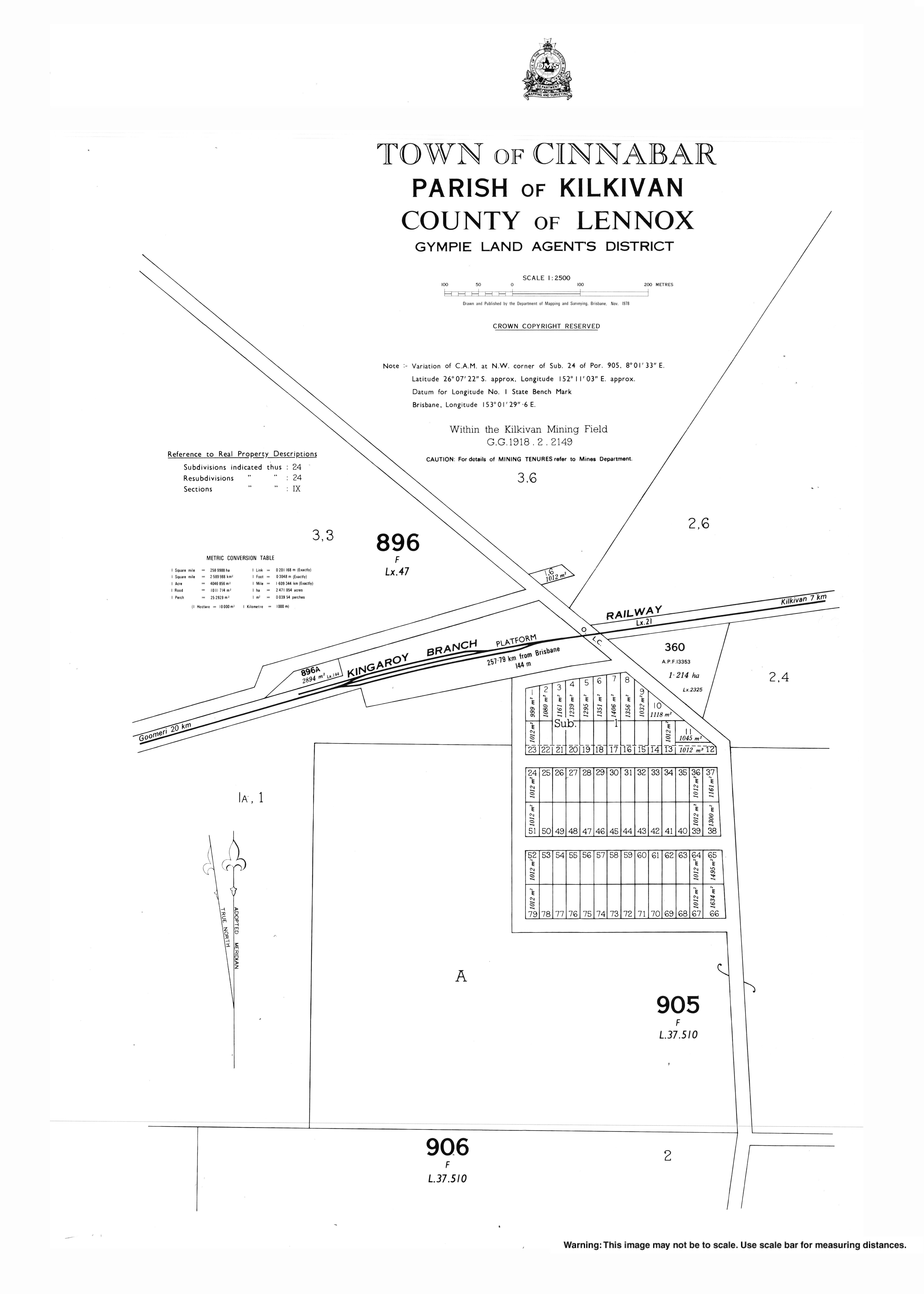
Kilkivan is a town and locality in the Gympie Region of Queensland, Australia. At the 2016 census, Kilkivan had a population of 713.

<span class="mw-page-title-main">Goomeri</span> Town in Queensland, Australia

Goomeri is a rural town and locality in the Gympie Region, Queensland, Australia. In the 2016 census, the locality of Goomeri had a population of 664 people.

<span class="mw-page-title-main">South Burnett</span> Region in Queensland, Australia

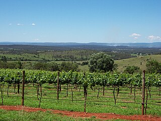
The South Burnett is a peanut growing and wine-producing area on the Great Dividing Range, north of the Darling Downs, in Queensland. It is with the basin of the Burnett River. The area is within two local government areas, South Burnett Region and Gympie Region.

<span class="mw-page-title-main">Tingoora</span> Town in Queensland, Australia

Tingoora is a rural town and a locality in the South Burnett Region, Queensland, Australia.

<span class="mw-page-title-main">Wooroolin, Queensland</span> Town in Queensland, Australia

Wooroolin is a rural town and a locality in the South Burnett Region, Queensland, Australia.

Theebine railway station is a closed railway station on the North Coast railway line of Queensland, Australia at Theebine. Slightly south of the railway station is the junction between the main North Coast line and the Kingaroy branch, which continues into west Queensland. It is also the junction for the Dickabram line.

<span class="mw-page-title-main">Theebine</span> Town in Queensland, Australia

Theebine is a rural town and locality split between the Gympie Region and the Fraser Coast Region, both in Queensland, Australia.

<span class="mw-page-title-main">Woolooga</span> Town in Queensland, Australia

Woolooga is a rural town and locality in the Gympie Region, Queensland, Australia. In the 2016 census the locality of Woolooga had a population of 247 people.

<span class="mw-page-title-main">Nanango railway line</span> Former railway line in Queensland, Australia

The Nanango railway line was a narrow-gauge branch railway located in Queensland, Australia. On 31 October 1882, parliament approved the construction of a branch line from Theebine west to Kilkivan after gold and copper were discovered in this region of Queensland, Australia. The section was opened in two stages – to Dickabram on 1 January 1886 after two crossings of the Mary River and to Kilkivan on 6 December 1886.

<span class="mw-page-title-main">Wide Bay–Burnett</span> Region in Queensland, Australia

Wide Bay–Burnett is a region of the Australian state of Queensland, located between 170–400 km (110–250 mi) north of the state capital, Brisbane. The area's population growth has exceeded the state average over the past 20 years, and it is forecast to grow to more than 430,000 by 2031. It is the subject of the Draft Wide Bay–Burnett Regional Plan, which aims to facilitate this growth while protecting over 90% of the region from urban development.

<span class="mw-page-title-main">Elgin Vale, Queensland</span> Suburb of Gympie Region, Queensland, Australia

Elgin Vale is a rural locality in the Gympie Region, Queensland, Australia. In the 2016 census, Elgin Vale had a population of 24 people.

<span class="mw-page-title-main">Miva, Queensland</span> Town in Queensland, Australia

Miva is a locality split between the Gympie Region and the Fraser Coast Region in Queensland, Australia. In the 2016 census Miva had a population of 57 people.

The Kilkivan to Kingaroy Rail Trail is an 88-kilometre (55 mi) recreation trail from Kilkivan to Kingaroy. The trail follows the old Kingaroy Branch railway and is open to walkers, cyclists and horse riders.

<span class="mw-page-title-main">Kinbombi</span> Town in Queensland, Australia

Kinbombi is a rural town and locality in the Gympie Region, Queensland, Australia. In the 2016 census, the locality of Kinbombi had a population of 37 people.

<span class="mw-page-title-main">Manumbar</span> Suburb of Gympie Region, Queensland, Australia

Manumbar is a rural locality in the Gympie Region, Queensland, Australia. In the 2016 census, Manumbar had a population of 53 people.

<span class="mw-page-title-main">Tansey, Queensland</span> Town in Queensland, Australia

Tansey is a rural town and locality in the Gympie Region, Queensland, Australia. In the 2016 census, Tansey had a population of 144 people.

Goomeribong is a rural locality in the Gympie Region, Queensland, Australia. In the 2021 census, Goomeribong had a population of 49 people.

Black Snake is a rural locality in the Gympie Region, Queensland, Australia. In the 2021 census, Black Snake had a population of 88 people.

References

  1. 1 2 3 Australian Bureau of Statistics (27 June 2017). "Cinnabar (SSC)". 2016 Census QuickStats. Retrieved 20 October 2018. OOjs UI icon edit-ltr-progressive.svg
  2. 1 2 "Cinnabar – locality in Gympie Region (entry 46316)". Queensland Place Names. Queensland Government . Retrieved 27 December 2020.
  3. 1 2 3 "Queensland Globe". State of Queensland . Retrieved 13 August 2022.
  4. "Mountain peaks and capes - Queensland". Queensland Open Data. Queensland Government. 12 November 2020. Archived from the original on 25 November 2020. Retrieved 25 November 2020.
  5. "The Breezer – mountain in Gympie Region (entry 33874)". Queensland Place Names. Queensland Government . Retrieved 25 November 2020.
  6. 1 2 McQueen, Kenneth (September 2011). "Mercury Mining: A quick history of quicksilver in Australia" (PDF). Journal of Australasian Mining History. 9: 74-93 [74, 77–79, 89-90]. ISSN   1448-4471. Archived from the original (PDF) on 14 August 2022.
  7. Kerr, John (1990). Triumph of narrow gauge : a history of Queensland Railways. Boolarong Publications. pp. 224–225. ISBN   978-0-86439-102-5.
  8. 1 2 "Railway stations and sidings - Queensland". Queensland Open Data. Queensland Government. 2 October 2020. Archived from the original on 5 October 2020. Retrieved 5 October 2020.
  9. 1 2 3 Queensland Family History Society (2010), Queensland schools past and present (Version 1.01 ed.), Queensland Family History Society, ISBN   978-1-921171-26-0
  10. "Kilkivan" (Map). Queensland Government. 1943. Archived from the original on 15 September 2020. Retrieved 13 August 2022.
  11. "Queensland Two Mile series sheet 2m113" (Map). Queensland Government. 1952. Archived from the original on 14 July 2021. Retrieved 14 August 2022.
  12. 1 2 "Kilkivan to Kingaroy Rail Trail". Gympie Regional Council. Archived from the original on 14 August 2022. Retrieved 13 August 2022.
  13. 1 2 "Rail Trail". South Burnett Regional Council. Archived from the original on 14 March 2022. Retrieved 13 August 2022.
  14. "New bridge at water crossing on Kilkivan to Kingaroy – Rail Trails Australia". 16 October 2021. RTA news. Retrieved 30 October 2022.
  15. "South Burnett Rail Trail". South Burnett Regional Council . Archived from the original on 1 November 2022. Retrieved 1 November 2022.