Wilsons Pocket

Last updated

Wilsons Pocket
Queensland
Australia Queensland location map.svg
Red pog.svg
Wilsons Pocket
Coordinates 26°07′29″S152°48′14″E / 26.1247°S 152.8038°E / -26.1247; 152.8038 (Wilsons Pocket (centre of locality)) Coordinates: 26°07′29″S152°48′14″E / 26.1247°S 152.8038°E / -26.1247; 152.8038 (Wilsons Pocket (centre of locality))
Population197 (2016 census) [1]
 • Density10.94/km2 (28.35/sq mi)
Postcode(s) 4570
Area18.0 km2 (6.9 sq mi)
Time zone AEST (UTC+10:00)
LGA(s) Gympie Region
State electorate(s) Gympie
Federal Division(s) Wide Bay
Suburbs around Wilsons Pocket:
Goomborian Goomborian Goomborian
Wolvi Wilsons Pocket Goomborian
Wolvi Wolvi Wolvi

Wilsons Pocket is a rural locality in the Gympie Region, Queensland, Australia. [2] In the 2016 census Wilsons Pocket had a population of 197 people. [1]

History

The locality was named after Albert Henry (Shepherd) Wilson, (1845 to 1886), one of the earliest landholders in the area. Wilson was born in Shepton Mallet, Somerset, England, and he immigrated to New South Wales on the "Bolton" in 1853. He married Mary Cahill at Proston station on 8 June 1869 and they had two sons. He selected Portion 1120, Parish of Goomborian on 20 July 1878 which was granted on 1 March 1883. From 1875 to about 1882, he worked at the Golden Crown gold mine in Gympie, but may have been farming his selection on Tinana Creek at the same time. He obtained a tin miner's licence in Herberton in April 1882 and died at the Mount Wells tin mine in the Northern Territory in 1886. Following Albert Wilson's death, the title for the property on Tinana Creek was transferred to his wife, Mary Wilson on 29 April 1887. [2]

Wilson's Pocket Provisional School opened in 1924. [3] By 1930 it had become Wilson's Pocket State School. [4] It closed in 1962. [5]

In the 2016 census Wilsons Pocket had a population of 197 people. [1]

Related Research Articles

Beaudesert, Queensland Town in Queensland, Australia

Beaudesert is a rural town and locality in the Scenic Rim Region, Queensland, Australia. In the 2016 census, Beaudesert had a population of 6,395 people.

Kenilworth, Queensland Town in Queensland, Australia

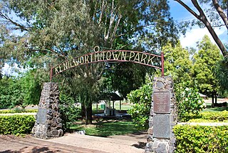
Kenilworth is a small town and locality in the heart of the Mary Valley area of the Sunshine Coast, Queensland, Australia. This is a rural area, about 50 kilometres (31 mi) from the coast, with dairy farming as the major industry. Local visitor attractions include a cheese factory as well as walking, camping and 4-wheel driving in the Kenilworth State Forest.

Kandanga, Queensland Town in Queensland, Australia

Kandanga is a town and a locality in the Gympie Region, Queensland, Australia. In the 2016 census, Kandanga had a population of 665 people.

Shire of Tiaro Local government area in Queensland, Australia

The Shire of Tiaro was a local government area in the Wide Bay–Burnett region of Queensland, Australia, between the regional cities of Gympie and Hervey Bay about 220 kilometres (137 mi) north of the state capital, Brisbane. The shire covered an area of 2,185.3 square kilometres (843.7 sq mi), and existed as a local government area from 1879 until 2008, when it was dissolved and split between two new local government areas, the Gympie Region and the Fraser Coast Region.

Tin Can Bay, Queensland Town in Queensland, Australia

Tin Can Bay is a coastal town and locality in the Wide Bay–Burnett region in Queensland, Australia. The locality is split between the Fraser Coast Region and the Gympie Region, but the town itself is within Gympie Region. In the 2016 census, Tin Can Bay had a population of 2,242 people.

Barambah, Queensland Suburb of Gympie Region, Queensland, Australia

Barambah is a rural locality in the Gympie Region, Queensland, Australia. In the 2016 census Barambah had a population of 46 people.

Monkland is a locality in the Gympie Region, Queensland, Australia.

Imbil Town in Queensland, Australia

Imbil is a rural town and locality in the Gympie Region, Queensland, Australia. In the 2016 census, Imbil had a population of 924 people.

Curra, Queensland Suburb of Gympie Region, Queensland, Australia

Curra is a locality in the Gympie Region, Queensland, Australia. At the 2016 census, Curra had a population of 1,920.

Tinana, Queensland Town in Queensland, Australia

Tinana is a town and a locality in the Fraser Coast Region, Queensland, Australia.

Widgee Suburb of Gympie Region, Queensland, Australia

Widgee is a rural locality in the Gympie Region, Queensland, Australia. In the 2016 census, Widgee had a population of 794 people.

The Shire of Widgee is a former local government area in the Wide Bay–Burnett area of Queensland, Australia. It was located in the rural areas around the town of Gympie but did not include the town itself, which was always in a separate local government area. The administrative offices of the Shire of Widgee were located in Gympie.

Morinish, Queensland Suburb of Rockhampton Region, Queensland, Australia

Morinish is a rural locality in the Rockhampton Region, Queensland, Australia. In the 2016 census Morinish had a population of 89 people.

Windera, Queensland Town in Queensland, Australia

Windera is a town in the South Burnett Region and a locality split between the South Burnett Region and the Gympie Region in Queensland, Australia. In the 2016 census the locality of Windera had a population of 93 people.

Wolvi, Queensland Suburb of Gympie Region, Queensland, Australia

Wolvi is a rural locality in the Gympie Region, Queensland, Australia. In the 2016 census, Wolvi had a population of 467 people.

Cedar Pocket, Queensland Suburb of Gympie Region, Queensland, Australia

Cedar Pocket is a rural locality in the Gympie Region, Queensland, Australia. In the 2016 census Cedar Pocket had a population of 339 people.

Manumbar Suburb of Gympie Region, Queensland, Australia

Manumbar is a rural locality in the Gympie Region, Queensland, Australia. In the 2016 census Manumbar had a population of 53 people.

Woondum Suburb of Gympie Region, Queensland, Australia

Woondum is a rural locality in the Gympie Region, Queensland, Australia. In the 2016 census Woondum had a population of 80 people.

Goomeribong, Queensland Suburb of Gympie Region, Queensland, Australia

Goomeribong is a locality in the Gympie Region, Queensland, Australia. In the 2016 census, Goomeribong had a population of 41 people.

Bella Creek, Queensland Suburb of Gympie Region, Queensland, Australia

Bella Creek is a rural locality in the Gympie Region, Queensland, Australia. In the 2016 census, Bella Creek had a population of 43 people.

References

  1. 1 2 3 Australian Bureau of Statistics (27 June 2017). "Wilsons Pocket (SSC)". 2016 Census QuickStats. Retrieved 20 October 2018. OOjs UI icon edit-ltr-progressive.svg
  2. 1 2 "Wilsons Pocket – locality in Gympie Region (entry 46400)". Queensland Place Names. Queensland Government . Retrieved 27 December 2020.
  3. "GYMPIE". The Brisbane Courier . Queensland, Australia. 31 May 1924. p. 10. Archived from the original on 28 January 2021. Retrieved 21 February 2020 via Trove.
  4. "COORAN". The Brisbane Courier . Queensland, Australia. 4 January 1930. p. 19. Archived from the original on 28 January 2021. Retrieved 21 February 2020 via Trove.
  5. Queensland Family History Society (2010), Queensland schools past and present (Version 1.01 ed.), Queensland Family History Society, ISBN   978-1-921171-26-0