Boonarga, Queensland

Last updated

Map all coordinates using: OpenStreetMap  
Download coordinates as: KML
Boonarga
Queensland
Cactoblastis Memorial Hall, Boonarga (2006).jpg
Cactoblastis Memorial Hall, Boonarga, 2006
Australia Queensland location map.svg
Red pog.svg
Boonarga
Coordinates 26°48′34″S150°43′13″E / 26.8094°S 150.7202°E / -26.8094; 150.7202 (Boonarga (centre of locality)) Coordinates: 26°48′34″S150°43′13″E / 26.8094°S 150.7202°E / -26.8094; 150.7202 (Boonarga (centre of locality))
Population36 (2016 census) [1]
 • Density0.625/km2 (1.619/sq mi)
Postcode(s) 4413
Area57.6 km2 (22.2 sq mi)
Time zone AEST (UTC+10:00)
Location
LGA(s) Western Downs Region
State electorate(s) Callide
Federal division(s) Maranoa
Suburbs around Boonarga:
Chinchilla Chances Plain Brigalow
Hopeland Boonarga Brigalow
Hopeland Hopeland Brigalow

Boonarga is a rural locality in the Western Downs Region, Queensland, Australia. [2] In the 2016 census, Boonarga had a population of 36 people. [1]

Contents

Geography

The Warrego Highway and Western railway line enter the locality from the south-east (Brigalow) and exit to the north-west (Chinchilla). [3]

Boonarga railway station is an abandoned station on the Western railway line ( 26°47′39″S150°42′55″E / 26.7942°S 150.7153°E / -26.7942; 150.7153 (Boonarga railway station) ). [4]

History

Hill Top Provisional School opened on 20 March 1893. On 1 January 1909, it became Hill Top State School. From 1914 to 1915 it operated as a half-time school with Mulga State School (meaning the two schools shared a single teacher). In 1936, it was renamed Boonarga State School. It closed in June 1954. [5] It was located on the Warrego Highway ( 26°47′27″S150°42′27″E / 26.7909°S 150.7075°E / -26.7909; 150.7075 (Boonarga State School (former)) ). [6] [7] [3]

The Cactoblastis Memorial Hall was built to celebrate the eradiction of the prickly pear in the Boonarga area through the introduction of the cactoblastis moth. [8] Prickly pear had spread so extensively through the area that it was often not possible to walk or ride through it. [9] [10] The hall was built by local builder Mr Jack Schloss at a cost of £ 435 and was officially opened in February 1936 by Godfrey Morgan, Member of the Queensland Legislative Assembly. [11] [12] A gala ball was held to mark the occasion. [13] [14]

In the 2016 census, Boonarga had a population of 36 people. [1]

Heritage listings

Boonarga has a number of heritage-listed sites, including:

Education

There are no schools in Boonarga. The nearest government primary schools are Brigalow State School in neighbouring Brigalow to the south-east and Chinchilla State School in neighbouring Chinchilla to the north-west. The nearest government secondary school is Chinchilla State High School in Chinchilla. [3]

Amenities

Boonarga Cactoblastis Memorial Hall is on the Warrego Highway ( 26°47′43″S150°42′56″E / 26.7952°S 150.7155°E / -26.7952; 150.7155 (Cactoblastis Memorial Hall) ). [16]

Related Research Articles

<span class="mw-page-title-main">Cunnamulla</span> Town in Queensland, Australia

Cunnamulla is a town and a locality in the Shire of Paroo, Queensland, Australia. It is 206 kilometres (128 mi) south of Charleville, and approximately 750 kilometres (470 mi) west of the state capital, Brisbane. In the 2016 census, Cunnamulla had a population of 1,140 people.

<span class="mw-page-title-main">Dalby, Queensland</span> Town in Queensland, Australia

Dalby is a rural town and locality in the Western Downs Region, Queensland, Australia. In the 2016 census, the locality of Dalby had a population of 12,719 people.

<span class="mw-page-title-main">Augathella</span> Town in Queensland, Australia

Augathella is a rural town and locality in the Shire of Murweh, Queensland, Australia.

<span class="mw-page-title-main">Wallumbilla, Queensland</span> Town in Queensland, Australia

Wallumbilla is a rural town and locality in the Maranoa Region, Queensland, Australia. In the 2016 census, the locality of Wallumbilla had a population of 388 people, with 191 people living in the town itself.

<span class="mw-page-title-main">Morven, Queensland</span> Town in Queensland, Australia

Morven is a rural town and locality in the Shire of Murweh, Queensland, Australia. In the 2016 census, the locality of Morven had a population of 199 people.

<span class="mw-page-title-main">Chinchilla, Queensland</span> Town in Queensland, Australia

Chinchilla is a rural town and locality in the Western Downs Region, Queensland, Australia. In the 2016 census, the locality of Chinchilla had a population of 6,612 people.

<span class="mw-page-title-main">Miles, Queensland</span> Town in Queensland, Australia

Miles is a rural town and locality in the Western Downs Region, Queensland, Australia. In the 2016 census, the locality of Miles had a population of 1,746 people.

<span class="mw-page-title-main">Yuleba</span> Town in Queensland, Australia

Yuleba is a rural town and locality in the Maranoa Region, in the south-west of Queensland, Australia. In the 2016 census, Yuleba had a population of 207 people.

<span class="mw-page-title-main">Warra, Queensland</span> Town in Queensland, Australia

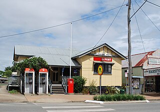
Warra is a rural town and locality in the Western Downs Region, Queensland, Australia. In the 2016 census, the locality of Warra had a population of 205 people.

<span class="mw-page-title-main">Brigalow, Queensland</span> Town in Queensland, Australia

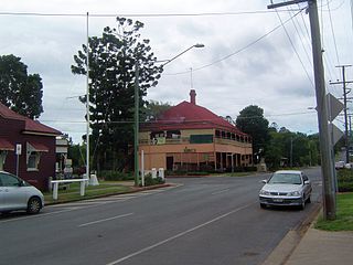
Brigalow is a rural town and locality in the Western Downs Region, Queensland, Australia. In the 2016 census the locality of Brigalow had a population of 170 people.

<span class="mw-page-title-main">Prickly pears in Australia</span>

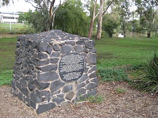
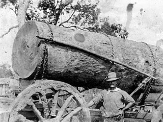
Prickly pears include a number of plant species that were introduced and have become invasive in Australia.

<span class="mw-page-title-main">Ideraway</span> Town in Queensland, Australia

Ideraway is a rural town and locality in the North Burnett Region, Queensland, Australia. In the 2016 census, the locality of Ideraway had a population of 38 people.

<span class="mw-page-title-main">Cactoblastis Memorial Hall</span> Historic site in Queensland, Australia

Cactoblastis Memorial Hall is a heritage-listed memorial at Warrego Highway, Boonarga, Western Downs Region, Queensland, Australia. It was built in 1936 by Jack Schloss. It was added to the Queensland Heritage Register on 21 September 1993.

<span class="mw-page-title-main">Barakula, Queensland</span> Suburb of Western Downs Region, Queensland, Australia

Barakula is a rural locality in the Western Downs Region, Queensland, Australia. In the 2016 census Barakula had a population of 13 people.

Canaga is a rural locality in the Western Downs Region, Queensland, Australia. In the 2016 census, Canaga had a population of 110 people.

<span class="mw-page-title-main">Hodgson, Queensland</span> Town in Queensland, Australia

Hodgson is a rural town and locality in the Maranoa Region, Queensland, Australia. In the 2016 census, the locality of Hodgson had a population of 61 people.

Cameby is a rural locality in the Western Downs Region, Queensland, Australia. In the 2016 census, Cameby had a population of 56 people.

Chinchilla–Wondai Road is a continuous 151.6 kilometres (94.2 mi) road route in the Western Downs and South Burnett regions of Queensland, Australia. Part of the route is signed as State Route 82. It is a state-controlled part regional and part district road. It provides an alternate route between the Warrego Highway and the South Burnett, bypassing Dalby, Oakey and Toowoomba.

Dalby–Jandowae Road is a continuous 47.3 kilometres (29.4 mi) road route in the Western Downs region of Queensland, Australia. The road is signed as State Route 82. Dalby–Jandowae Road is a state-controlled regional road.

Dalby–Cecil Plains Road is a continuous 39.1 kilometres (24.3 mi) road route in the Western Downs and Toowoomba regions of Queensland, Australia. The road is signed as State Route 82. Dalby–Cecil Plains Road is a state-controlled regional road.

References

  1. 1 2 3 Australian Bureau of Statistics (27 June 2017). "Boonarga (SSC)". 2016 Census QuickStats. Retrieved 20 October 2018. OOjs UI icon edit-ltr-progressive.svg
  2. "Boonarga – locality in Western Downs Region (entry 47669)". Queensland Place Names. Queensland Government . Retrieved 14 December 2020.
  3. 1 2 3 "Queensland Globe". State of Queensland . Retrieved 24 December 2022.
  4. "Railway stations and sidings - Queensland". Queensland Open Data. Queensland Government. 2 October 2020. Archived from the original on 5 October 2020. Retrieved 5 October 2020.
  5. Queensland Family History Society (2010), Queensland schools past and present (Version 1.01 ed.), Queensland Family History Society, ISBN   978-1-921171-26-0
  6. "Queensland Two Mile series sheet 2m81" (Map). Queensland Government. 1953. Archived from the original on 10 November 2021. Retrieved 10 November 2021.
  7. "County of Lytton" (Map). Queensland Government. 1921. Archived from the original on 24 December 2022. Retrieved 24 December 2022.
  8. "MEMORIAL TO CACTOBLASTIS". The Queenslander . Queensland, Australia. 15 November 1934. p. 10. Retrieved 25 December 2022 via National Library of Australia.
  9. "A SURVEY & SOME OPINIONS". The Sydney Mail . Vol. XLVIII, no. 1241. New South Wales, Australia. 8 January 1936. p. 6. Retrieved 25 December 2022 via National Library of Australia.
  10. "Reclaiming a Lost Province—1". The Courier-mail . No. 966. Queensland, Australia. 3 October 1936. p. 22. Retrieved 25 December 2022 via National Library of Australia.
  11. "Northern Floods—New Church at Bundaberg Cactoblastis Honoured—Giant Footwear". The Queenslander . Queensland, Australia. 5 March 1936. p. 29. Retrieved 25 December 2022 via National Library of Australia.
  12. "SCIENCE WAGES WAR ON". Sunday Mail . No. 323. Queensland, Australia. 28 June 1936. p. 27. Retrieved 25 December 2022 via National Library of Australia.
  13. "Cactoblastis Memorial Hall (entry 601273)". Queensland Heritage Register . Queensland Heritage Council. Retrieved 1 August 2014.
  14. "AUSTRALIANA". The World's News . No. 1795. New South Wales, Australia. 6 May 1936. p. 12. Retrieved 25 December 2022 via National Library of Australia.
  15. "Cactoblastis Memorial Hall (entry 601273)". Queensland Heritage Register . Queensland Heritage Council. Retrieved 16 July 2013.
  16. "Community Halls". Western Downs Regional Council . Archived from the original on 3 March 2016. Retrieved 10 November 2021.

Commons-logo.svg Media related to Boonarga, Queensland at Wikimedia Commons