
Dalby is a rural town and locality in the Western Downs Region, Queensland, Australia. In the 2021 census, the locality of Dalby had a population of 12,758 people.

Chinchilla is a rural town and locality in the Western Downs Region, Queensland, Australia. Chinchilla is known as the 'Melon Capital of Australia', and plays host to a Melon Festival every second year in February.
Killarney is a rural town and locality in the Southern Downs Region, Queensland, Australia. It borders New South Wales. In the 2021 census, the locality of Killarney had a population of 918 people.

Kholo is a rural locality in the City of Brisbane, Queensland, Australia. In the 2021 census, Kholo had a population of 374 people.

Kaimkillenbun is a rural town and locality in the Western Downs Region, Queensland, Australia. In the 2021 census, the locality of Kaimkillenbun had a population of 248 people.
Condamine is a rural town and locality in the Western Downs Region, Queensland, Australia. In the 2021 census, the locality of Condamine had a population of 294 people.
The Gums is a rural town and locality in the Western Downs Region, Queensland, Australia. In the 2021 census, the locality of The Gums had a population of 165 people.

Macalister is a rural town and locality in the Western Downs Region, Queensland, Australia. In the 2021 census, the locality of Macalister had a population of 156 people.

Warra is a rural town and locality in the Western Downs Region, Queensland, Australia. In the 2021 census, the locality of Warra had a population of 180 people.

Bowenville is a rural town and locality in the Toowoomba Region, Queensland, Australia. The town's economy rested on the rail industry and with the winding down of the railways the population declined. In the 2021 census, the locality of Bowenville had a population of 219 people.
Moola is a rural locality in the Western Downs Region, Queensland, Australia. In the 2021 census, Moola had a population of 218 people.
Kogan is a rural town and locality in the Western Downs Region, Queensland, Australia. In the 2021 census, the locality of Kogan had a population of 211 people.
Wheatvale is a rural locality in the Southern Downs Region, Queensland, Australia. In the 2021 census, Wheatvale had a population of 57 people.

Goomburra is a rural town and locality in the Southern Downs Region, Queensland, Australia. In the 2021 census, the locality of Goomburra had a population of 256 people.
Tuckerang is a rural locality in the Western Downs Region, Queensland, Australia. In the 2021 census, Tuckerang had a population of 111 people.

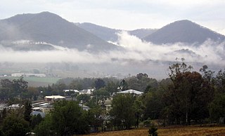
Bunya Mountains is a locality split between the Western Downs Region and the South Burnett Region, Queensland, Australia. The town of Mount Mowbullan is located on the boundary of Bunya Mountains and the enclosed locality of Mowbullan. In the 2021 census, Bunya Mountains had a population of 110 people.
Rosehill is a rural locality in the Southern Downs Region, Queensland, Australia. In the 2021 census, Rosehill had a population of 134 people.
St Ruth is a locality split between the Western Downs Region and the Toowoomba Region in Queensland, Australia. In the 2021 census, St Ruth had a population of 165 people.

Nandi is a rural locality in the Western Downs Region, Queensland, Australia. In the 2021 census, Nandi had a population of 105 people.
Irvingdale is a locality split between the Toowoomba Region and the Western Downs Region, both in Queensland, Australia. In the 2021 census, Irvingdale had a population of 163 people.
