Blaxland, Queensland

Last updated

Blaxland
Queensland
Australia Queensland location map.svg
Red pog.svg
Blaxland
Coordinates 27°13′07″S151°24′01″E / 27.2186°S 151.4002°E / -27.2186; 151.4002 Coordinates: 27°13′07″S151°24′01″E / 27.2186°S 151.4002°E / -27.2186; 151.4002
Population35 (2016 census) [1]
 • Density0.366/km2 (0.948/sq mi)
Postcode(s) 4405
Elevation360 m (1,181 ft) [2]
Area95.6 km2 (36.9 sq mi)
Time zone AEST (UTC+10:00)
LGA(s) Western Downs Region
State electorate(s) Warrego
Federal Division(s) Maranoa
Suburbs around Blaxland:
Irvingdale Irvingdale Irvingdale
Dalby Blaxland Bowenville
Bowenville Bowenville Bowenville

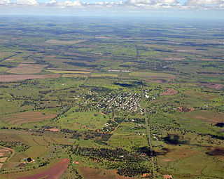
Blaxland is a rural locality in the Western Downs Region, Queensland, Australia. [3] In the 2016 census, Blaxland had a population of 35 people. [1]

Suburbs and localities are the names of geographic subdivisions in Australia, used mainly for address purposes. The term locality is used in rural areas, while the term suburb is used in urban areas. Australian postcodes closely align with the boundaries of localities and suburbs.

Western Downs Region Local government area in Queensland, Australia

Western Downs Region is a local government area in Queensland, Australia. The Western Downs Regional Council manages an area of 38,039 square kilometres (14,687 sq mi), which is approximately the same size as the country of Switzerland, although with a population at the last census of close to 33,000, it is over 235 times less densely populated.

Queensland North-east state of Australia

Queensland is the second-largest and third-most populous state in the Commonwealth of Australia. Situated in the north-east of the country, it is bordered by the Northern Territory, South Australia and New South Wales to the west, south-west and south respectively. To the east, Queensland is bordered by the Coral Sea and Pacific Ocean. To its north is the Torres Strait, with Papua New Guinea located less than 200 km across it from the mainland. The state is the world's sixth-largest sub-national entity, with an area of 1,852,642 square kilometres (715,309 sq mi).

Contents

Geography

The Western railway line forms the southern boundary of the locality, while Myall Creek forms the northern boundary. [2]

Western railway line, Queensland

The Western railway line is a narrow gauge railway, connecting the south-east and south-west regions of Queensland, Australia. It commences at Toowoomba, at the end of the Main Line railway from Brisbane, and extends west 810 km to Cunnamulla, passing through the major towns of Dalby, Roma and Charleville, although services on the 184 km section from Westgate to Cunnamulla have been suspended since 2011. Queensland was the first railway operator in the world to adopt narrow gauge for a main line, and this remains the system wide gauge.

The land is flat and predominantly used for cropping. [2]

History

In the 1860s Edward James Blaxland purchased land originally known as Three Mile Scrub and named the property Blaxland. When the Western railway line reached the area in 1868, the railway station was called Blaxland. [3] [4]

Education

There are no schools in Blaxland. The nearest primary schools in neighbouring Dalby and Bowenville. The nearest secondary schools are in Dalby. [2]

Dalby, Queensland Town in Queensland, Australia

Dalby is a town and locality in the Darling Downs region of Queensland, Australia. Dalby is within and is the administrative centre of the Western Downs Region. At the 2016 census, Dalby had a population of 12,719.

Bowenville, Queensland Town in Queensland, Australia

Bowenville is a rural town and locality in the Toowoomba Region, Queensland, Australia. The town's economy rested on the rail industry and with the winding down of the railways the population declined. In the 2016 census, Bowenville had a population of 250 people.

Related Research Articles

Kaimkillenbun Town in Queensland, Australia

Kaimkillenbun is a town and a locality in the Western Downs Region, Queensland, Australia. At the 2011 census, Kaimkillenbun and the surrounding area had a population of 566.

Bell, Queensland Town in Queensland, Australia

Bell is a rural town and locality in the Western Downs Region, Queensland, Australia. It is in the western foothills of the Bunya Mountains, 39 kilometres (24 mi) north of Dalby. At the 2016 census, Bell had a population of 502.

The Gums, Queensland Town in Queensland, Australia

The Gums is a rural town and locality in the Western Downs Region, Queensland, Australia.

Captains Mountain, Queensland Suburb of Toowoomba Region, Queensland, Australia

Captains Mountain is a locality in the Toowoomba Region, Queensland, Australia. In the 2016 census, Captains Mountain had a population of 77 people.

Cooranga, Queensland Suburb of Western Downs Region, Queensland, Australia

Cooranga is a locality in the Western Downs Region, Queensland, Australia. In the 2016 census, Cooranga had a population of 133 people.

Cottonvale, Queensland Suburb of Southern Downs Region, Queensland, Australia

Cottonvale is a locality in the Southern Downs Region, Queensland, Australia. In the 2016 census, Cottonvale had a population of 148 people. It contains the town of Cotton Vale.

Fletcher, Queensland Suburb of Southern Downs Region, Queensland, Australia

Fletcher is a rural locality in the Southern Downs Region, Queensland, Australia. In the 2016 census, Fletcher had a population of 92 people.

Glen Niven, Queensland Suburb of Southern Downs Region, Queensland, Australia

Glen Niven is a locality in the Southern Downs Region, Queensland, Australia. It is within the Granite Belt on the Darling Downs and adjacent to the border with New South Wales. In the 2016 census, Glen Niven had a population of 80 people.

Balberra, Queensland Suburb of Mackay Region, Queensland, Australia

Balberra is a coastal locality in the Mackay Region, Queensland, Australia. In the 2016 census, Balberra had a population of 457 people.

Nandi, Queensland Suburb of Western Downs Region, Queensland, Australia

Nandi is a locality in the Western Downs Region, Queensland, Australia. In the 2016 census, Nandi had a population of 108 people.

Millmerran Downs, Queensland Suburb of Toowoomba Region, Queensland, Australia

Millmerran Downs is a locality in the Toowoomba Region, Queensland, Australia. In the 2016 census, Millmerran Downs had a population of 89 people.

Barcaldine Downs Suburb of Barcaldine Region, Queensland, Australia

Barcaldine Downs is a rural locality in the Barcaldine Region, Queensland, Australia. In the 2016 census, Barcaldine Downs had a population of 14 people.

Moombria, Queensland Suburb of Barcaldine Region, Queensland, Australia

Moombria is a locality in the Barcaldine Region, Queensland, Australia. In the 2016 census, Moombria had a population of 0 people.

Beaufort, Queensland Suburb of Barcaldine Region, Queensland, Australia

Beaufort is a locality in the Barcaldine Region, Queensland, Australia. In the 2016 census, Beaufort had a population of 46 people.

Drummondslope, Queensland Suburb of Barcaldine Region, Queensland, Australia

Drummondslope is a locality in the Barcaldine Region, Queensland, Australia. In the 2016 census, Drummondslope had a population of 43 people.

Garfield, Queensland Suburb of Barcaldine Region, Queensland, Australia

Garfield is a locality in the Barcaldine Region, Queensland, Australia. In the 2016 census, Garfield had a population of 37 people.

Mexico, Queensland Suburb of Barcaldine Region, Queensland, Australia

Mexico is a locality in the Barcaldine Region, Queensland, Australia. In the 2016 census, Mexico had a population of 26 people.

Pine Hill, Queensland Suburb of Barcaldine Region, Queensland, Australia

Pine Hill is a locality in the Barcaldine Region, Queensland, Australia. In the 2016 census, Pine Hill had a population of 3 people.

Port Wine, Queensland Suburb of Barcaldine Region, Queensland, Australia

Port Wine is a locality in the Barcaldine Region, Queensland, Australia. In the 2016 census, Port Wine had a population of 27 people.

Sedgeford, Queensland Suburb of Barcaldine Region, Queensland, Australia

Sedgeford is a locality in the Barcaldine Region, Queensland, Australia. In the 2016 census, Sedgeford had a population of 0 people.

References

  1. 1 2 Australian Bureau of Statistics (27 June 2017). "Blaxland (SSC)". 2016 Census QuickStats. Retrieved 20 October 2018.
  2. 1 2 3 4 "Queensland Globe". State of Queensland . Retrieved 10 August 2019.
  3. 1 2 "Blaxland - locality in Western Downs Region (entry 47667)". Queensland Place Names. Queensland Government . Retrieved 12 June 2019.
  4. "Blaxland - railway in the Western Downs Region (entry 3161)". Queensland Place Names. Queensland Government . Retrieved 10 August 2019.