
The Moonie Highway is a state highway of Queensland, Australia. Part of State Route 49, it leaves the Warrego Highway at Dalby and runs for over 290 km until it reaches St George. From there, State Route 49 continues west as the Balonne Highway. From Dalby, it continues north-east as the Bunya Highway.

Thallon is a town and a locality in the Shire of Balonne, Queensland, Australia. In the 2021 census, the locality of Thallon had a population of 231 people.

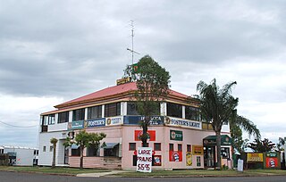
Moonie is a rural town in the Western Downs Region and a locality split between the Western Downs Region and the Goondiwindi Region in Queensland, Australia. In the 2021 census, the locality of Moonie had a population of 182 people.
Te Kowai is a rural locality in the Mackay Region, Queensland, Australia. In the 2021 census, Te Kowai had a population of 227 people.

Drillham is a rural town and locality in the Western Downs Region, Queensland, Australia. In the 2021 census, the locality of Drillham had a population of 113 people.

Macalister is a rural town and locality in the Western Downs Region, Queensland, Australia. In the 2021 census, the locality of Macalister had a population of 156 people.
Dulacca is a rural town and locality in the Western Downs Region, Queensland, Australia. In the 2021 census, the locality of Dulacca had a population of 131 people.
Racecourse is a western suburb of Mackay in the Mackay Region, Queensland, Australia. In the 2021 census, Racecourse had a population of 181 people.
Kumbarilla is a town and rural locality in the Western Downs Region, Queensland, Australia. In the 2021 census, the locality of Kumbarilla had a population of 223 people.
Westmar is a rural locality in the Western Downs Region, Queensland, Australia. In the 2021 census, Westmar had a population of 59 people.
Calingunee is a rural locality in the Goondiwindi Region, Queensland, Australia. In the 2021 census, Calingunee had a population of 18 people.
Ooralea is a southern suburb of Mackay in the Mackay Region, Queensland, Australia. In the 2021 census, Ooralea had a population of 3,691 people.
Teelba is a rural locality in the Maranoa Region, Queensland, Australia. In the 2021 census, Teelba had a population of 82 people.
Southwood is a rural town and locality in the Western Downs Region, Queensland, Australia. In the 2016 census, the locality of Southwood had a population of 84 people.
Ducklo is a locality in the Western Downs Region, Queensland, Australia. In the 2021 census, Ducklo had a population of 306 people.
Bundi is a rural locality in the Western Downs Region, Queensland, Australia. In the 2021 census, Bundi had a population of 52 people.
Coomrith is a locality in the Western Downs Region, Queensland, Australia. In the 2021 census, Coomrith had a population of 52 people.

Nandi is a rural locality in the Western Downs Region, Queensland, Australia. In the 2021 census, Nandi had a population of 105 people.
Marmadua is a rural locality in the Western Downs Region, Queensland, Australia. In the 2021 census, Marmadua had a population of 15 people.
Kings Siding is a rural locality in the Toowoomba Region, Queensland, Australia. In the 2021 census, Kings Siding had a population of 15 people.
