Guluguba, Queensland

Last updated

Guluguba
Queensland
Cafe at Guluguba on the Leichhardt Highway, Queensland.JPG
Cafe at Guluguba on the Leichhardt Highway, 2014
Australia Queensland location map.svg
Red pog.svg
Guluguba
Coordinates 26°15′25″S150°02′40″E / 26.2569°S 150.0444°E / -26.2569; 150.0444 (Guluguba (town centre))
Population109 (2016 census) [1]
 • Density0.2812/km2 (0.728/sq mi)
Postcode(s) 4418
Area387.6 km2 (149.7 sq mi)
Time zone AEST (UTC+10:00)
Location
  • 18.8 km (12 mi) SE of Wandoan
  • 50.0 km (31 mi) NNW of Miles
  • 177 km (110 mi) NW of Dalby
  • 387 km (240 mi) NW of Brisbane
LGA(s) Western Downs Region
State electorate(s) Callide
Federal division(s) Maranoa
Localities around Guluguba:
Wandoan Wandoan Roche Creek
Woleebee Guluguba Pelham
Woleebee Gurulmundi Pelham

Guluguba is a rural town and locality in the Western Downs Region, Queensland, Australia. [2] [3] In the 2016 census, the locality of Guluguba had a population of 109 people. [1]

Contents

Geography

Guluguba is located on the Leichhardt Highway, north of Miles and south of Wandoan. [4]

The now-closed Wandoan railway line traversed the locality with the town being served by the Guluguba railway station ( 26°15′24″S150°02′42″E / 26.2567°S 150.0451°E / -26.2567; 150.0451 (Guluguba railway station) ) with the Giligulgul railway station ( 26°21′12″S150°02′59″E / 26.3532°S 150.0496°E / -26.3532; 150.0496 (Giligulgul railway station) ) at the south of the locality. [5]

History

The name Guluguba is thought to be an Aboriginal word meaning squatter pigeon. [2] [3]

Guluguba Post Office opened by 1916 (a receiving office had been open from 1915). [6]

Guluguba Provisional School opened on 1 February 1917 on a half-time basis (meaning shared a single teacher) with Downfall Creek Provisional School which opened in March 1917. When the Downfall Creek school closed in 1918, Guluguba became a full-time school. [7]

The first stage of the Wandoan railway line opened from Miles to Giligulgul railway station on 20 December 1913. The second stage from Giligulgul to Juandah, including Guluguba railway station, opened on 16 December 1914. [8]

In 1931, St John's Lutheran church was opened by a group of German settlers who had moved from South Australia. [9]

In 1940 at Downfall Creek, the local Lutheran community established a Lutheran Day School. Meanwhile, Guluguba State School had two temporary closures in 1942 and 1944 due to a lack of teacher accommodation. [7]

In 1957, the Queensland Education Department was willing to provide a teacher to Downfall Creek so the Lutheran Church school became Downfall Creek Provisional School once again. It finally closed in 1962. [7]

In the 2011 census, Guluguba was counted together with neighbouring Wandoan and had a combined population of 655. [10]

In the 2016 census, the locality of Guluguba had a population of 109 people. [1]

Education

Guluguba State School is a government primary (Prep-6) school for boys and girls at Fosters Road ( 26°15′24″S150°02′39″E / 26.2567°S 150.0441°E / -26.2567; 150.0441 (Guluguba State School) ). [11] [12] In 2016, the school had an enrolment of 6 students with 2 teachers (1 full-time equivalent) and 4 non-teaching staff (2 equivalent full-time). [13] In 2018, the school had an enrolment of 13 students with 2 teachers (1 full-time equivalent) and 6 non-teaching staff (2 full-time equivalent). [14]

There are no secondary schools in Guluguba. The nearest government secondary schools are Wandoan State School (to Year 10) in neighbouring Wandoan to the north and Miles State High School (to Year 12) in Miles to the south. [4]

Amenities

St John's Lutheran Church (also known as the Downfall Creek Lutheran Church) is at 654 Upper Downfall Creek Road ( 26°15′20″S150°08′58″E / 26.2555°S 150.1494°E / -26.2555; 150.1494 (St John's Lutheran Church) ). [15] [9]

Notable people

Related Research Articles

<span class="mw-page-title-main">Westwood, Queensland</span> Town in Queensland, Australia

Westwood is a town in the Rockhampton Region and a locality split between the Rockhampton Region and the Shire of Banana in Queensland, Australia. It was the first town that was gazetted by the Queensland Government. In the 2021 census, the locality of Westwood had a population of 199 people.

<span class="mw-page-title-main">Chinchilla, Queensland</span> Town in Queensland, Australia

Chinchilla is a rural town and locality in the Western Downs Region, Queensland, Australia. In the 2021 census, the locality of Chinchilla had a population of 7,068 people.

<span class="mw-page-title-main">Aratula</span> Town in Queensland, Australia

Aratula is a rural town and locality in the Scenic Rim Region, Queensland, Australia. In the 2016 census, the locality of Aratula had a population of 532 people.

<span class="mw-page-title-main">Wandoan</span> Town in Queensland, Australia

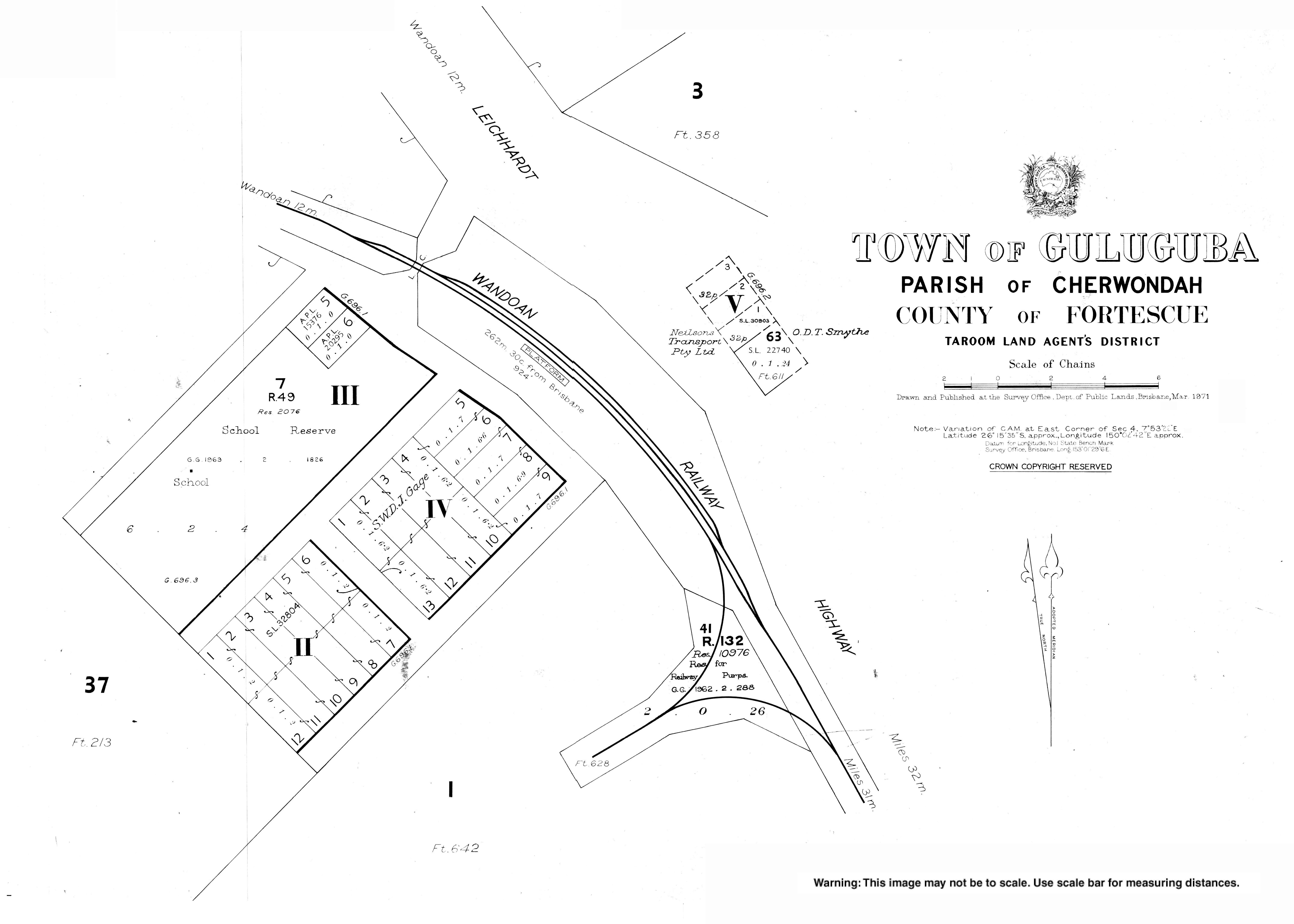
Wandoan is a town and locality in the Western Downs Region, Queensland, Australia. It was formerly known as Juandah. It is on the Leichhardt Highway about halfway between Taroom and Miles and is the centre for the local cattle industry. In the 2016 census, Wandoan had a population of 566 people.

<span class="mw-page-title-main">Thangool</span> Town in Queensland, Australia

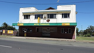
Thangool is a rural town and locality in the Shire of Banana, Queensland, Australia. In the 2016 census, the locality of Thangool had a population of 741 people.

<span class="mw-page-title-main">Goovigen</span> Town in Queensland, Australia

Goovigen is a rural town and locality in the Shire of Banana, Queensland, Australia. In the 2016 census, the locality of Goovigen had a population of 215 people.

<span class="mw-page-title-main">Wowan, Queensland</span> Town in Queensland, Australia

Wowan is a rural town and locality in the Shire of Banana, Queensland, Australia. In the 2016 census, the locality of Wowan had a population of 216 people.

<span class="mw-page-title-main">Hivesville, Queensland</span> Town in Queensland, Australia

Hivesville is a rural town and locality in the South Burnett Region, Queensland, Australia. In the 2016 census, the locality of Hivesville had a population of 169 people.

<span class="mw-page-title-main">Jambin, Queensland</span> Town in Queensland, Australia

Jambin is a rural town and locality in the Shire of Banana, Queensland, Australia. In the 2021 census, the locality of Jambin had a population of 207 people.

<span class="mw-page-title-main">Marmor, Queensland</span> Town in Queensland, Australia

Marmor is a rural town and locality in the Rockhampton Region, Queensland, Australia. In the 2016 census, the locality of Marmor had a population of 212 people.

<span class="mw-page-title-main">Macalister, Queensland</span> Town in Queensland, Australia

Macalister is a rural town and locality in the Western Downs Region, Queensland, Australia. In the 2016 census, the locality of Macalister had a population of 153.

<span class="mw-page-title-main">Brigalow, Queensland</span> Town in Queensland, Australia

Brigalow is a rural town and locality in the Western Downs Region, Queensland, Australia. In the 2016 census the locality of Brigalow had a population of 170 people.

<span class="mw-page-title-main">Wandoan railway line</span>

The Wandoan Branch is a 70 km railway line in the Darling Downs region Queensland, Australia. It links the towns of Miles and Wandoan. It was approved to extend to Taroom, but construction halted during World War I and never recommenced. The line is now closed.

<span class="mw-page-title-main">Koongal, Queensland</span> Suburb of Rockhampton Region, Queensland, Australia

Koongal is a suburb of Rockhampton in the Rockhampton Region, Queensland, Australia. At the 2016 census, Koongal had a population of 4,286 people.

<span class="mw-page-title-main">Bouldercombe</span> Town in Queensland, Australia

Bouldercombe is a rural town and locality in the Rockhampton Region, Queensland, Australia. In the 2016 census, the locality of Bouldercombe had a population of 1,085 people.

<span class="mw-page-title-main">Teviotville, Queensland</span> Town in Queensland, Australia

Teviotville is a rural locality in the Scenic Rim Region, Queensland, Australia. In the 2021 census, Teviotville had a population of 114 people.

<span class="mw-page-title-main">Beebo, Queensland</span> Suburb of Goondiwindi Region, Queensland, Australia

Beebo is a rural locality in the Goondiwindi Region, Queensland, Australia. It is on the Queensland border with New South Wales. In the 2016 census, Beebo had a population of 84 people.

<span class="mw-page-title-main">Bergen, Queensland</span> Suburb of Toowoomba Region, Queensland, Australia

Bergen is a rural locality in the Toowoomba Region, Queensland, Australia. In the 2016 census, Bergen had a population of 68 people.

<span class="mw-page-title-main">Dalwogon, Queensland</span> Suburb of Western Downs Region, Queensland, Australia

Dalwogon is a rural locality in the Western Downs Region, Queensland, Australia. In the 2021 census, Dalwogon had a population of 53 people.

Wura is a rural locality in the Rockhampton Region, Queensland, Australia. In the 2021 census, Wura had a population of 17 people.

References

  1. 1 2 3 Australian Bureau of Statistics (27 June 2017). "Guluguba (SSC)". 2016 Census QuickStats. Retrieved 20 October 2018. OOjs UI icon edit-ltr-progressive.svg
  2. 1 2 "Guluguba – town in Western Downs Region (entry 14951)". Queensland Place Names. Queensland Government . Retrieved 7 March 2022.
  3. 1 2 "Guluguba – locality in Western Downs Region (entry 47706)". Queensland Place Names. Queensland Government . Retrieved 7 March 2022.
  4. 1 2 "Queensland Globe". State of Queensland . Retrieved 19 June 2022.
  5. "Railway stations and sidings - Queensland". Queensland Open Data. Queensland Government. 2 October 2020. Archived from the original on 5 October 2020. Retrieved 5 October 2020.
  6. Premier Postal History. "Post Office List". Premier Postal Auctions. Archived from the original on 15 May 2014. Retrieved 10 May 2014.
  7. 1 2 3 Queensland Family History Society (2010), Queensland schools past and present (Version 1.01 ed.), Queensland Family History Society, ISBN   978-1-921171-26-0
  8. Kerr, John (1990). Triumph of narrow gauge : a history of Queensland Railways. Boolarong Publications. pp. 224–225. ISBN   978-0-86439-102-5.
  9. 1 2 Blake, Thom. "St John's Lutheran Church". Queensland religious places database. Archived from the original on 19 June 2022. Retrieved 19 June 2022.
  10. Australian Bureau of Statistics (31 October 2012). "Wandoan (SSC)". 2011 Census QuickStats. Retrieved 28 April 2014. OOjs UI icon edit-ltr-progressive.svg
  11. "State and non-state school details". Queensland Government. 9 July 2018. Archived from the original on 21 November 2018. Retrieved 21 November 2018.
  12. "Guluguba State School". Guluguba State School. 14 January 2020. Archived from the original on 7 March 2016. Retrieved 19 June 2022.
  13. "Annual Report 2016" (PDF). Guluguba State School. Archived (PDF) from the original on 16 September 2017. Retrieved 16 September 2017.
  14. "ACARA School Profile 2018". Australian Curriculum, Assessment and Reporting Authority. Archived from the original on 27 August 2020. Retrieved 28 January 2020.
  15. "Downfall Creek Lutheran Church". South Western Queensland Lutheran Parish. Archived from the original on 29 November 2020. Retrieved 27 February 2021.
  16. "Meet Deb". Deb Frecklington MP. Archived from the original on 30 November 2017. Retrieved 29 November 2017.

Further reading