Eurombah, Queensland

Last updated

Map all coordinates using: OpenStreetMap  
Download coordinates as: KML
Eurombah
Queensland
Fraser family grave site and memorial, Hornet Bank (2008).jpg
Hornet Bank massacre graves, 2008
Australia Queensland location map.svg
Red pog.svg
Eurombah
Coordinates 25°57′11″S149°23′08″E / 25.9530°S 149.3855°E / -25.9530; 149.3855 (Eurombah (centre of locality)) Coordinates: 25°57′11″S149°23′08″E / 25.9530°S 149.3855°E / -25.9530; 149.3855 (Eurombah (centre of locality))
Population67 (2016 census) [1]
 • Density0.0672/km2 (0.1740/sq mi)
Postcode(s) 4420
Area997.5 km2 (385.1 sq mi)
Time zone AEST (UTC+10:00)
Location
LGA(s)
State electorate(s) Callide
Federal division(s)
Suburbs around Eurombah:
Baroondah Kinnoul Taroom
Baroondah Eurombah Grosmont
Waikola Clifford Bundi

Eurombah is a rural locality split between the Shire of Banana and the Western Downs Region, Queensland, Australia. [2] [3] In the 2016 census, Eurombah had a population of 67 people. [1]

Contents

Geography

The Dawson River forms part of the northern boundary. [4]

The neighbourhoods of Peek-A-Doo and Hornet Bank are within the locality.

History

The Hornet Bank massacre in 1857 happened nearby. [5]

The Peek-A-Doo State School opened on 3 February 1964 at 10118 Roma Taroom Road ( 25°54′29″S149°29′58″E / 25.9081°S 149.4995°E / -25.9081; 149.4995 (Peek-A-Doo State School (former)) ). [6] [7] [8] It was mothballed on 13 April 2010 (having no students). [9] [10] [11] In June 2010, there was outrage when it was announced that the then-mothballed school would be allocated $250,000 by the Australian Government's Building the Education Revolution school building program to construct a resource centre. [12] However, it was not constructed as the school closed on 31 December 2010. [9] [13] The school's website was archived. [14]

In the 2016 census, Eurombah had a population of 67 people. [1]

Heritage listings

Eurombah has a number of heritage-listed sites, including:

Education

There are no schools in Eurombah. The nearest primary schools are Taroom State School in Taroom and Gromont State School in Grosmont. The nearest secondary schools are Taroom State School and Wandoan State School in Wandoan, but both of these schools provide education only to Year 10. For schooling to Year 12, the nearest option is Roma State College in Roma, 125 kilometres (78 mi) away. Other alternatives are distance education and boarding schools. [16]

Related Research Articles

Wallumbilla, Queensland Town in Queensland, Australia

Wallumbilla is a rural town and locality in the Maranoa Region, Queensland, Australia. In the 2016 census, the locality of Wallumbilla had a population of 388 people, with 191 people living in the town itself.

Woorabinda, Queensland Town in Queensland, Australia

Woorabinda is a rural town and locality in the Aboriginal Shire of Woorabinda, Queensland, Australia. In the 2016 census, Woorabinda had a population of 962 people. It is an Aboriginal community.

Taroom Town in Queensland, Australia

Taroom is a town in the Shire of Banana and locality split between the Shire of Banana and the Western Downs Region in Queensland, Australia. At the 2016 census, Taroom had a population of 869 people.

Carmila, Queensland Town in Queensland, Australia

Carmila is a rural town and coastal locality in the Isaac Region, Queensland, Australia. In the 2016 census, the locality of Carmila had a population of 333 people.

Shire of Taroom Local government area in Queensland, Australia

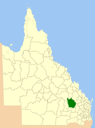
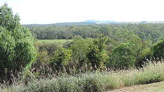
The Shire of Taroom was a local government area in the Darling Downs region of Queensland, Australia, along the Leichhardt Highway to the north of Miles. The shire covered an area of 18,644.5 square kilometres (7,198.7 sq mi), and existed as a local government area from 1879 until 2008, when it was dissolved and split between the new Western Downs Region and the Shire of Banana.
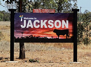
Shire of Murilla Local government area in Queensland, Australia

The Shire of Murilla was a local government area located in the Darling Downs region of Queensland, Australia. The shire, administered from the town of Miles, covered an area of 6,075.8 square kilometres (2,345.9 sq mi), and existed as a local government entity from 1879 until 2008, when it amalgamated with the Town of Dalby and the Shires of Chinchilla, Tara and Wambo and the southern part of Taroom to form the Western Downs Region.

Shire of Wambo Local government area in Queensland, Australia

The Shire of Wambo was a local government area in the Darling Downs region of Queensland, Australia. The shire surrounded but did not include the town of Dalby – which had its own municipal government. It covered an area of 5,709.7 square kilometres (2,204.5 sq mi), and existed as a local government entity from 1879 until 2008, when it amalgamated with the Town of Dalby and the Shires of Chinchilla, Murilla and Tara and the southern part of Taroom to form the Western Downs Region.

Wandoan Town in Queensland, Australia

Wandoan is a town and locality in the Western Downs Region, Queensland, Australia. It was formerly known as Juandah. It is on the Leichhardt Highway about halfway between Taroom and Miles and is the centre for the local cattle industry. In the 2016 census, Wandoan had a population of 566 people.

The Hornet Bank massacre involves the killing of eleven British colonists and one Aboriginal station-hand, by a group of Iman Aboriginal Australians. The massacre occurred at about one or two o'clock in the morning of 27 October 1857 at Hornet Bank station on the upper Dawson River near Eurombah in central Queensland, Australia. It has been moderately estimated that 150 Aboriginal people succumbed in subsequent punitive missions conducted by Native Police, private settler militias, and by William Fraser in or around Eurombah district. Indiscriminate shootings of "over 300" Aboriginal men, women, and children, however, were reportedly conducted by private punitive expedition some 400 kilometres eastward at various stations in the Wide Bay district alone. The result was the believed extermination of the entire Iman tribe and language group by 1858; this claim was disputed, however, and descendants of this group have recently been recognised by the High Court of Australia to be the original custodians of the land surrounding the town of Taroom.

Memerambi, Queensland Town in Queensland, Australia

Memerambi is a rural town and locality in the South Burnett Region, Queensland, Australia. In the 2016 census, the locality of Memerambi had a population of 272 people.

Wandoan railway line

The Wandoan Branch is a 70 km railway line in the Darling Downs region Queensland, Australia. It links the towns of Miles and Wandoan. It was approved to extend to Taroom, but construction halted during World War I and never recommenced.

Western railway line, Queensland Railway line in Queensland, Australia

The Western railway line is a narrow gauge railway, connecting the south-east and south-west regions of Queensland, Australia. It commences at Toowoomba, at the end of the Main Line railway from Brisbane, and extends west 810 km to Cunnamulla, passing through the major towns of Dalby, Roma and Charleville, although services on the 184 km section from Westgate to Cunnamulla have been suspended since 2011. The Queensland Government was the first railway operator in the world to adopt narrow gauge for a main line, and this remains the system-wide gauge.

Cockatoo, Queensland Suburb of Shire of Banana, Queensland, Australia

Cockatoo is a rural locality in the Shire of Banana, Queensland, Australia. In the 2016 census, Cockatoo had a population of 36 people.

Fraser family grave site and memorial, Hornet Bank

The Fraser family grave site and memorial at Hornet Bank is a heritage-listed cemetery and memorial at Hornet Bank Station, Hornet Bank Road, Eurombah near Taroom, Shire of Banana, Queensland, Australia. It was added to the Queensland Heritage Register on 18 September 2008.

The Yiman, also known as Yeeman, Eoman or Jiman, and by themselves in modern times as Iman, are an Aboriginal Australian people living in the Upper Dawson River region around Taroom of eastern Central Queensland.

Grosmont is a rural locality in the Western Downs Region, Queensland, Australia. In the 2016 census, Grosmont had a population of 141 people.

Barakula, Queensland Suburb of Western Downs Region, Queensland, Australia

Barakula is a rural locality in the Western Downs Region, Queensland, Australia. In the 2016 census Barakula had a population of 13 people.

Spring Creek is a rural locality in the Shire of Banana, Queensland, Australia. In the 2016 census Spring Creek had a population of 15 people.

Kinnoul is a rural locality in the Shire of Banana, Queensland, Australia. In the 2016 census Kinnoul had a population of 69 people.

Wild Toby was a famous Aboriginal outlaw from the Dawson River region of central Queensland.

References

  1. 1 2 3 Australian Bureau of Statistics (27 June 2017). "Eurombah (SSC)". 2016 Census QuickStats. Retrieved 20 October 2018. OOjs UI icon edit-ltr-progressive.svg
  2. "Eurombah – Shire of Banana (entry 49550)". Queensland Place Names. Queensland Government . Retrieved 26 August 2016.
  3. "Eurombah – Western Downs Region (entry 47697)". Queensland Place Names. Queensland Government . Retrieved 26 August 2016.
  4. Google (29 August 2021). "Eurombah, Queensland" (Map). Google Maps . Google. Retrieved 29 August 2021.
  5. Laurie, Arthur (1 January 1957), Hornet Bank massacre : October 27, 1857, Royal Historical Society of Queensland, archived from the original on 17 September 2016, retrieved 26 August 2016 — full text available on-line via the University of Queensland Archived 7 July 2020 at the Wayback Machine 25°45′S149°24′E / 25.750°S 149.400°E
  6. Queensland Family History Society (2010), Queensland schools past and present (Version 1.01 ed.), Queensland Family History Society, ISBN   978-1-921171-26-0
  7. Chiclcott, Tanya; Vlasic, Kimberley (7 June 2013). "Full school asssets sale list". The Courier-Mail . Archived from the original on 30 October 2019. Retrieved 30 October 2019.
  8. "Hornet Bank" (Map). Queensland Government. 1972. Archived from the original on 8 April 2022. Retrieved 8 April 2022.
  9. 1 2 "Opening and closing dates of Queensland Schools". Queensland Government . Retrieved 25 October 2019.
  10. "Agency ID 11101, Peek-A-Doo State School". Queensland State Archives . Retrieved 26 October 2019.
  11. Mesner, Kerri-Anne (9 June 2010). "Five schools face closure review". Gladstone Observer . Archived from the original on 26 October 2019. Retrieved 26 October 2019.
  12. "Rudd Government spends $4.5m at Queensland schools on closure hit list". The Courier-Mail . 7 June 2010. Retrieved 26 October 2019.
  13. "Queensland state school - centre closures" (PDF). Queensland Government . 20 August 2013. Archived (PDF) from the original on 20 March 2022. Retrieved 6 April 2022.
  14. "Peek-A-Doo State School". Peek-A-Doo State School. 27 October 2009. Archived from the original on 27 October 2009. Retrieved 8 April 2022.
  15. "Fraser family grave site and memorial, Hornet Bank (entry 602075)". Queensland Heritage Register . Queensland Heritage Council. Retrieved 6 July 2013.
  16. "Queensland Globe". State of Queensland . Retrieved 29 March 2020.