
Banana is a rural town and locality in the Shire of Banana, Queensland, Australia. In the 2021 census, the locality of Banana had a population of 348 people.
Blue Mountain Heights is a residential locality in the Toowoomba Region, Queensland, Australia. In the 2021 census, Blue Mountain Heights had a population of 988 people.
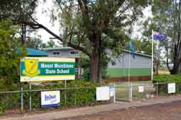
Mount Murchison is a rural locality in the Shire of Banana, Queensland, Australia.

Eurombah is a rural locality split between the Shire of Banana and the Western Downs Region, Queensland, Australia. In the 2021 census, Eurombah had a population of 100 people.
Broadmere is a rural locality in the Shire of Banana, Queensland, Australia. In the 2021 census, Broadmere had a population of 38 people.
Pheasant Creek is a rural locality in the Shire of Banana, Queensland, Australia. In the 2021 census, Pheasant Creek had a population of 48 people.
Dumpy Creek is a rural locality in the Shire of Banana, Queensland, Australia. In the 2021 census, Dumpy Creek had a population of 16 people.
Orient is a coastal locality in the Shire of Hinchinbrook, Queensland, Australia. In the 2021 census, Orient had "no people or a very low population".
Caroline Crossing is a rural locality in the Shire of Murweh, Queensland, Australia. In the 2021 census, Caroline Crossing had a population of 44 people.
Stockyard is a coastal locality in the Livingstone Shire, Queensland, Australia. The town of Stockyard Point is located within the locality. In the 2021 census, Stockyard had a population of 16 people.
Shoalwater is a coastal locality in the Livingstone Shire, Queensland, Australia. In the 2021 census, Shoalwater had "no people or a very low population".
Dumgree is a rural locality in the Shire of Banana, Queensland, Australia. In the 2021 census, Dumgree had a population of 63 people.
Roundstone is a rural locality in the Shire of Banana, Queensland, Australia. In the 2021 census, Roundstone had a population of 78 people.
Coorada is a rural locality in the Shire of Banana, Queensland, Australia. In the 2021 census, Coorada had "no people or a very low population".
Ghinghinda is a rural locality in the Shire of Banana, Queensland, Australia. In the 2021 census, Ghinghinda had a population of 47 people.
Gwambegwine is a rural locality in the Shire of Banana, Queensland, Australia. In the 2021 census, Gwambegwine had a population of 27 people.
Taroomball is a rural locality in the Livingstone Shire, Queensland, Australia. In the 2021 census, Taroomball had a population of 1,136 people.
Staaten is a rural locality in the Shire of Mareeba, Queensland, Australia. In the 2021 census, Staaten had "no people or a very low population".
Bolwarra is a rural locality in the Shire of Mareeba, Queensland, Australia. In the 2021 census, Bolwarra had "no people or a very low population".

Springfield is a rural locality in the Shire of Mareeba, Queensland, Australia. In the 2021 census, Springfield had a population of 14 people.
