Prospect, Queensland

Last updated

Map all coordinates using: OpenStreetMap  
Download coordinates as: KML
Prospect
Queensland
Prospect Creek State School, grounds and signage, 2020.jpg
Prospect State School, 2020
Australia Queensland location map.svg
Red pog.svg
Prospect
Coordinates 24°29′50″S150°24′58″E / 24.4972°S 150.4161°E / -24.4972; 150.4161 (Prospect (centre of locality)) Coordinates: 24°29′50″S150°24′58″E / 24.4972°S 150.4161°E / -24.4972; 150.4161 (Prospect (centre of locality))
Population297 (2016 census) [1]
 • Density0.7122/km2 (1.845/sq mi)
Postcode(s) 4715
Area417.0 km2 (161.0 sq mi)
Time zone AEST (UTC+10:00)
Location
LGA(s) Shire of Banana
State electorate(s) Callide
Federal division(s) Flynn
Suburbs around Prospect:
Banana Orange Creek Dakenba
Biloela
Banana Prospect Valentine Plains
Tarramba Castle Creek Thangool

Prospect is a rural locality in the Shire of Banana, Queensland, Australia. [2] In the 2016 census, Prospect had a population of 297 people. [1]

Contents

Geography

Prospect Creek is a neighbourhood ( 24°25′00″S150°26′00″E / 24.4166°S 150.4333°E / -24.4166; 150.4333 (Prospect Creek (neighbourhood)) ). [3]

Mount Bulgi ( 24°28′20″S150°21′59″E / 24.4723°S 150.3663°E / -24.4723; 150.3663 (Mount Bulgi) ) rises to 484 metres (1,588 ft) above sea level. [4] [5]

History

Torsdale Farm Provisional School opened on 16 July 1919 as a half-time provisional school in conjunction with Torsdale Station Provisional School (meaning they shared a single teacher). Both schools closed on 31 December 1920 due to low student numbers. [6]

Kooingal State School opened on 4 June 1931. It closed on 8 July 1956. [6] It was at 1382 Crowsdale Camboon Road ( 24°31′43″S150°25′38″E / 24.5287°S 150.4271°E / -24.5287; 150.4271 (Kooingal State School (former)) ). [7]

On 2 October 1935, Torsdale Farm Provisional School reopened. In 1944, approval was given for the establishment of a Prospect Creek State School to replace the provisional school at Torsdale Farm on the same site. Prospect Creek State School opened on 5 June 1944. [6] [8] [9] [10] [7]

The mobile library service commenced in 2004. [11]

In the 2016 census Prospect had a population of 297 people. [1]

Education

Prospect Creek State School is a government primary (Prep-6) school for boys and girls at 12935 Dawson Highway ( 24°25′16″S150°25′45″E / 24.4211°S 150.4293°E / -24.4211; 150.4293 (Prospect Creek State School) ). [12] [13] In 2018, the school had an enrolment of 42 students with 4 teachers (3 full-time equivalent) and 6 non-teaching staff (3 full-time equivalent). [14]

There are no secondary schools in Prospect. The nearest government secondary school is Biloela State High School in neighbouring Biloela to the north-east. [15]

Amenities

Banana Shire Council provides a fortnightly mobile library service at Prospect Creek School. [16] [17]

Related Research Articles

<span class="mw-page-title-main">Biloela</span> Town in Queensland, Australia

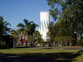
Biloela is a rural town and locality in Shire of Banana, Central Queensland, Australia. It is situated 120 kilometres (75 mi) inland from the port city of Gladstone at the junction of the Burnett and Dawson highways. Biloela is the administrative centre of Banana Shire, which has an area of 15,729 square kilometres (6,073 sq mi). In the 2021 census, the locality of Biloela had a population of 5,692 people.

<span class="mw-page-title-main">Banana, Queensland</span> Town in Queensland, Australia

Banana is a rural town and locality in the Shire of Banana, Queensland, Australia. In the 2016 census, the locality of Banana had a population of 356 people.

<span class="mw-page-title-main">Dawson Highway</span>

The Dawson Highway is a state highway in Queensland, Australia. It runs for 405 kilometres (252 mi) between Gladstone and Springsure where it terminates. From Gladstone to Rolleston it is signed as State Route 60, and then A7 onwards to Springsure. It continues west for another 247 kilometres (153 mi) as Dawson Developmental Road to Tambo on the Landsborough Highway. North of Springsure, A7 becomes the Gregory Highway.

<span class="mw-page-title-main">Theodore, Queensland</span> Town in Queensland, Australia

Theodore is a rural town and locality in the Shire of Banana, Queensland, Australia. In the 2016 census the locality of Theodore had a population of 438 people.

<span class="mw-page-title-main">Baralaba, Queensland</span> Town in Queensland, Australia

Baralaba is a rural town and locality in the Shire of Banana in central Queensland, Australia. In the 2016 census, Baralaba had a population of 314 people.

<span class="mw-page-title-main">Shire of Banana</span> Local government area in Queensland, Australia

The Shire of Banana is a local government area located in the Capricorn region of Queensland, Australia, inland from the regional city of Gladstone. The shire was named after the first township in the region (Banana), which in turn was named for the burial site of a huge dun coloured bullock named 'Banana'. The council sits in the town of Biloela, which is the largest town in the Shire.

<span class="mw-page-title-main">Dululu</span> Town in Queensland, Australia

Dululu is a rural town and locality in the Shire of Banana, Queensland, Australia. In the 2016 census, the locality of Dululu had a population of 126 people.

<span class="mw-page-title-main">Cracow, Queensland</span> Town in Queensland, Australia

Cracow is a rural town and locality in the Shire of Banana, Queensland, Australia. In the 2016 census, the locality of Cracow had a population of 89 people.

<span class="mw-page-title-main">Thangool</span> Town in Queensland, Australia

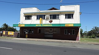
Thangool is a rural town and locality in the Shire of Banana, Queensland, Australia. In the 2016 census, the locality of Thangool had a population of 741 people.

<span class="mw-page-title-main">Goovigen</span> Town in Queensland, Australia

Goovigen is a rural town and locality in the Shire of Banana, Queensland, Australia. In the 2016 census, the locality of Goovigen had a population of 215 people.

<span class="mw-page-title-main">Wowan, Queensland</span> Town in Queensland, Australia

Wowan is a rural town and locality in the Shire of Banana, Queensland, Australia. In the 2016 census, the locality of Wowan had a population of 216 people.

<span class="mw-page-title-main">Rannes, Queensland</span> Town in Queensland, Australia

Rannes is a rural town in the west of the locality of Goovigen in the Shire of Banana, Queensland, Australia.

<span class="mw-page-title-main">Jambin, Queensland</span> Town in Queensland, Australia

Jambin is a rural town and locality in the Shire of Banana, Queensland, Australia.

<span class="mw-page-title-main">Mount Murchison, Queensland</span> Suburb of Shire of Banana, Queensland, Australia

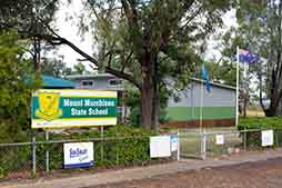
Mount Murchison is a rural locality in the Shire of Banana, Queensland, Australia.

Spring Creek is a rural locality in the Shire of Banana, Queensland, Australia. In the 2016 census Spring Creek had a population of 15 people.

Callide is a rural town and locality in the Shire of Banana, Queensland, Australia. In the 2016 census, the locality of Callide had a population of 86 people.

Greycliffe is a rural locality in the Shire of Banana, Queensland, Australia. In the 2016 census, Greycliffe had a population of 22 people.

<span class="mw-page-title-main">Lawgi Dawes</span> Suburb of Shire of Banana, Queensland, Australia

Lawgi Dawes is a rural locality in the Shire of Banana, Queensland, Australia. In the 2016 census, Lawgi Dawes had a population of 144 people. It contains the neighbourhood of Lawgi, a former town.

Dakenba is a rural locality in the Shire of Banana, Queensland, Australia. In the 2016 census, Dakenba had a population of 116 people.

Orange Creek is a rural locality in the Shire of Banana, Queensland, Australia.

References

  1. 1 2 3 Australian Bureau of Statistics (27 June 2017). "Prospect (SSC)". 2016 Census QuickStats. Retrieved 20 October 2018. OOjs UI icon edit-ltr-progressive.svg
  2. "Prospect – locality in Shire of Banana (entry 49568)". Queensland Place Names. Queensland Government . Retrieved 26 December 2020.
  3. "Prospect Creek – locality unbounded in Shire of Banana (entry 27557)". Queensland Place Names. Queensland Government . Retrieved 26 December 2020.
  4. "Mountain peaks and capes - Queensland". Queensland Open Data. Queensland Government. 12 November 2020. Archived from the original on 25 November 2020. Retrieved 25 November 2020.
  5. "Mount Bulgi – mountain in Banana Shire (entry 4964)". Queensland Place Names. Queensland Government . Retrieved 25 November 2020.
  6. 1 2 3 Queensland Family History Society (2010), Queensland schools past and present (Version 1.01 ed.), Queensland Family History Society, ISBN   978-1-921171-26-0
  7. 1 2 "Queensland Two Mile series sheet 2m163" (Map). Queensland Government. 1950. Archived from the original on 27 December 2022. Retrieved 27 December 2022.
  8. "Opening and closing dates of Queensland Schools". Queensland Government . Retrieved 18 April 2019.
  9. "PROSPECT CREEK SCHOOL". Morning Bulletin . No. 25, 195. Queensland, Australia. 11 July 1944. p. 5. Retrieved 2 February 2018 via National Library of Australia.
  10. "History". Prospect Creek State School. 17 August 2021. Retrieved 27 December 2022.
  11. "Public Libraries Statistical Bulletin 2016-17" (PDF). Public Libraries Connect. State Library of Queensland. November 2017. p. 11. Retrieved 29 January 2018.
  12. "State and non-state school details". Queensland Government. 9 July 2018. Archived from the original on 21 November 2018. Retrieved 21 November 2018.
  13. "Prospect Creek State School". Prospect Creek State School. 29 November 2020. Retrieved 27 December 2022.
  14. "ACARA School Profile 2018". Australian Curriculum, Assessment and Reporting Authority . Retrieved 28 January 2020.
  15. "Queensland Globe". State of Queensland . Retrieved 27 December 2022.
  16. "Library: Branches & Opening hours". Banana Shire Council. Archived from the original on 19 March 2017. Retrieved 8 May 2017.
  17. "Mobile library timetable". Banana Shire Council . Retrieved 27 December 2022.