Dixalea, Queensland

Last updated

Dixalea
Queensland
Australia Queensland location map.svg
Red pog.svg
Dixalea
Coordinates 23°57′14″S150°18′55″E / 23.9538°S 150.3152°E / -23.9538; 150.3152 (Dixalea (centre of locality))
Population102 (SAL 2021) [1]
Postcode(s) 4702
Area229.3 km2 (88.5 sq mi)
Time zone AEST (UTC+10:00)
Location
LGA(s) Shire of Banana
State electorate(s) Callide
Federal division(s) Flynn
Suburbs around Dixalea:
Dululu Dululu Ulogie
Wowan Dixalea Ulogie
Goovigen Goovigen Goovigen

Dixalea is a rural locality in the Shire of Banana, Queensland, Australia. [2] In the 2021 census, Dixalea had a population of 102 people. [3]

Contents

Geography

The Dee River forms the north-western boundary of the locality. [4] The Don River enters the locality from the east (Ulogie) and exits to the west (Wowan / Goovigen). [5]

The Burnett Highway enters the locality from the north (Dululu) and exits to the south (Goovigen). [5]

The terrain ranges from 110 to 240 metres (360 to 790 ft) above sea level. The locality is mostly flat with the higher elevations in the north-east of the locality. [5]

The land use is predominantly crop growing around the rivers with the remainder of the locality being used for grazing on native vegetation. [5]

History

Don River State School opened on 21 August 1916 with an initial enrolment of 50 students. [6] [7] [8] [9] It closed on 25 January 1932, but reopened on 18 April 1933 having been relocated to a more central position on Mcdonalds Road ( 23°58′19″S150°18′29″E / 23.9720°S 150.3080°E / -23.9720; 150.3080 (Don River State School (former)) ). [10] [11] [5] . It closed again in 1952 and reopened in 1958 before finally closing on 5 June 1964, by which time it had been relocated south of the Don River to Tomlins Road (approx 23°59′31″S150°18′23″E / 23.9920°S 150.3065°E / -23.9920; 150.3065 (Don River State School (former)) ). [12]

Dixie State School opened on 30 October 1923. In 1924, it was renamed Dixalea State School. It closed in 1938. [12] It was at approx 120 Dixalea Doreen Road ( 23°56′45″S150°17′32″E / 23.9457°S 150.2923°E / -23.9457; 150.2923 (Dixalea State School (former)) ). [13] [5]

Demographics

In the 2016 census, Dixalea had a population of 92 people. [14]

In the 2021 census, Dixalea had a population of 102 people. [3]

Education

There are no schools in Dixalea. The nearest government primary schools are Wowan State School in neighbouring Wowan to the east, Goovigen State School in neighbouring Goovigen to the south-west, and Jambin State School in Jambin to the south. The nearest government secondary schools are Mount Morgan State High School in Mount Morgan to the north and Biloela State High School in Biloela to the south-east. [15]

Related Research Articles

<span class="mw-page-title-main">Biloela</span> Town in Queensland, Australia

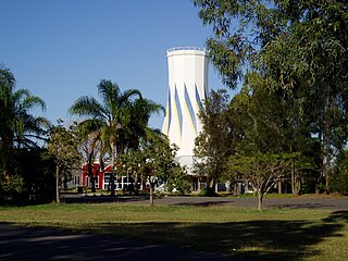
Biloela is a rural town and locality in the Shire of Banana, Central Queensland, Australia. It is situated 120 kilometres (75 mi) inland from the port city of Gladstone at the junction of the Burnett and Dawson highways. Biloela is the administrative centre of Banana Shire, which has an area of 15,729 square kilometres (6,073 sq mi). In the 2021 census, the locality of Biloela had a population of 5,692 people.

<span class="mw-page-title-main">Banana, Queensland</span> Town in Queensland, Australia

Banana is a rural town and locality in the Shire of Banana, Queensland, Australia. In the 2016 census, the locality of Banana had a population of 356 people.

<span class="mw-page-title-main">Shire of Banana</span> Local government area in Queensland, Australia

The Shire of Banana is a local government area located in the Capricorn region of Queensland, Australia, inland from the regional city of Gladstone. The shire was named after the first township in the region (Banana), which in turn was named for the burial site of a huge dun coloured bullock named 'Banana'. The council sits in the town of Biloela, which is the largest town in the Shire.

<span class="mw-page-title-main">Dululu</span> Town in Queensland, Australia

Dululu is a rural town and locality in the Shire of Banana, Queensland, Australia.In the 2021 census, the locality of Dululu had a population of 97 people.

<span class="mw-page-title-main">Wowan, Queensland</span> Town in Queensland, Australia

Wowan is a rural town and locality in the Shire of Banana, Queensland, Australia. In the 2016 census, the locality of Wowan had a population of 216 people.

<span class="mw-page-title-main">Rannes, Queensland</span> Town in Queensland, Australia

Rannes is a rural town in the west of the locality of Goovigen in the Shire of Banana, Queensland, Australia.

<span class="mw-page-title-main">Jambin, Queensland</span> Town in Queensland, Australia

Jambin is a rural town and locality in the Shire of Banana, Queensland, Australia. In the 2021 census, the locality of Jambin had a population of 207 people.

<span class="mw-page-title-main">Ambrose, Queensland</span> Town in Queensland, Australia

Ambrose is a rural town and locality in the Gladstone Region, Queensland, Australia. In the 2016 census, the locality of Ambrose had a population of 218 people.

<span class="mw-page-title-main">Mount Murchison, Queensland</span> Suburb of Shire of Banana, Queensland, Australia

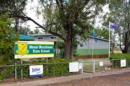
Mount Murchison is a rural locality in the Shire of Banana, Queensland, Australia.

Prospect is a rural locality in the Shire of Banana, Queensland, Australia. In the 2016 census, Prospect had a population of 297 people.

Callide is a rural town and locality in the Shire of Banana, Queensland, Australia. In the 2016 census, the locality of Callide had a population of 86 people.

Greycliffe is a rural locality in the Shire of Banana, Queensland, Australia. In the 2016 census, Greycliffe had a population of 22 people.

Valentine Plains is a rural locality in the Shire of Banana, Queensland, Australia. In the 2016 census, Valentine Plains had a population of 394 people.

Tablelands is a rural locality in the Gladstone Region, Queensland, Australia. In the 2021 census, Tablelands had a population of 9 people.

<span class="mw-page-title-main">Lawgi Dawes</span> Suburb of Shire of Banana, Queensland, Australia

Lawgi Dawes is a rural locality in the Shire of Banana, Queensland, Australia. In the 2016 census, Lawgi Dawes had a population of 144 people. It contains the neighbourhood of Lawgi, a former town.

Dakenba is a rural locality in the Shire of Banana, Queensland, Australia. In the 2016 census, Dakenba had a population of 116 people.

Orange Creek is a rural locality in the Shire of Banana, Queensland, Australia. In the 2021 census, Orange Creek had a population of 197 people.

<span class="mw-page-title-main">Mount Alma, Queensland</span> Suburb of Gladstone Region, Queensland, Australia

Mount Alma is a rural locality in the Gladstone Region, Queensland, Australia. In the 2016 census, Mount Alma had a population of 47 people.

Wura is a rural locality in the Rockhampton Region, Queensland, Australia. In the 2021 census, Wura had a population of 17 people.

References

  1. Australian Bureau of Statistics (28 June 2022). "Dixalea (suburb and locality)". Australian Census 2021 QuickStats. Retrieved 28 June 2022.  OOjs UI icon edit-ltr-progressive.svg
  2. "Dixalea – locality in Shire of Banana (entry 49546)". Queensland Place Names. Queensland Government . Retrieved 26 December 2020.
  3. 1 2 Australian Bureau of Statistics (28 June 2022). "Dixalea (SAL)". 2021 Census QuickStats. Retrieved 28 February 2023. OOjs UI icon edit-ltr-progressive.svg
  4. Google (15 September 2021). "Dixalea, Queensland" (Map). Google Maps . Google. Retrieved 15 September 2021.
  5. 1 2 3 4 5 6 "Queensland Globe". State of Queensland . Retrieved 2 February 2024.
  6. "DON RIVER SCHOOL". Morning Bulletin . No. 16, 004. Queensland, Australia. 11 November 1915. p. 6. Retrieved 1 February 2024 via National Library of Australia.
  7. "TENDERS ACCEPTED". The Telegraph . No. 13, 527. Queensland, Australia. 30 March 1916. p. 3. Retrieved 1 February 2024 via National Library of Australia.
  8. "OFFICIAL NOTIFICATIONS". The Capricornian . Vol. 41, no. 31. Queensland, Australia. 29 July 1916. p. 30. Retrieved 1 February 2024 via National Library of Australia.
  9. "DAWSON VALLEY SCHOOLS". Morning Bulletin . No. 16, 244. Queensland, Australia. 5 September 1916. p. 4. Retrieved 1 February 2024 via National Library of Australia.
  10. "WOWAN". The Central Queensland Herald . Vol. 4, no. 171. Queensland, Australia. 6 April 1933. p. 39. Retrieved 2 February 2024 via National Library of Australia.
  11. "Queensland Two Mile series sheet 2m201" (Map). Queensland Government. 1954. Archived from the original on 3 May 2021. Retrieved 11 April 2022.
  12. 1 2 Queensland Family History Society (2010), Queensland schools past and present (Version 1.01 ed.), Queensland Family History Society, ISBN   978-1-921171-26-0
  13. "Queensland Two Mile series sheet 2m201" (Map). Queensland Government. 1937. Archived from the original on 9 April 2022. Retrieved 11 April 2022.
  14. Australian Bureau of Statistics (27 June 2017). "Dixalea (SSC)". 2016 Census QuickStats. Retrieved 20 October 2018. OOjs UI icon edit-ltr-progressive.svg
  15. "Layers: Locality; Schools and school catchments". Queensland Globe. Queensland Government. Archived from the original on 19 December 2017. Retrieved 31 January 2024.