
Theodore is a rural town and locality in the Shire of Banana, Queensland, Australia. It was established in the 1920s as part of Queensland Premier Ted Theodore's ambitious Dawson River Irrigation Scheme which failed to eventuate. It was originally known as Castle Creek, but that name is now used by another locality in the area.
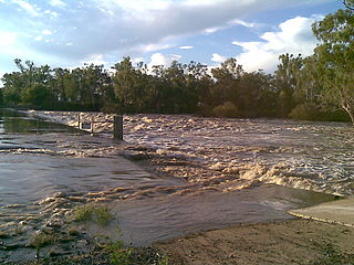
The Dawson River is a river in Central Queensland, Australia.
Taroom is a town in the Shire of Banana and locality split between the Shire of Banana and the Western Downs Region in Queensland, Australia. In the 2021 census, Taroom had a population of 885 people.
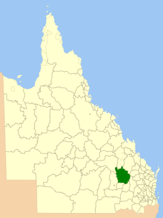
The Shire of Taroom was a local government area in the Darling Downs region of Queensland, Australia, along the Leichhardt Highway to the north of Miles. The shire covered an area of 18,644.5 square kilometres (7,198.7 sq mi), and existed as a local government area from 1879 until 2008, when it was dissolved and split between the new Western Downs Region and the Shire of Banana.

Eurombah is a rural locality split between the Shire of Banana and the Western Downs Region, Queensland, Australia. In the 2021 census, Eurombah had a population of 100 people.
Grosmont is a rural locality in the Western Downs Region, Queensland, Australia. In the 2021 census, Grosmont had a population of 135 people.
Spring Creek is a rural locality in the Shire of Banana, Queensland, Australia. In the 2021 census, Spring Creek had a population of 20 people.

Kokotungo is a rural locality in the Shire of Banana, Queensland, Australia. In the 2021 census, Kokotungo had a population of 89 people.

Broadmere is a rural locality in the Shire of Banana, Queensland, Australia. In the 2021 census, Broadmere had a population of 38 people.
Ulogie is a rural locality in the Shire of Banana, Queensland, Australia. In the 2021 census, Ulogie had a population of 31 people.

Bungaban is a rural locality in the Western Downs Region, Queensland, Australia. In the 2021 census, Bungaban had a population of 60 people.
Alberta is a rural locality in the Shire of Banana, Queensland, Australia. In the 2021 census, Alberta had a population of 36 people.

Lonesome Creek is a rural locality in the Shire of Banana, Queensland, Australia. In the 2021 census, Lonesome Creek had a population of 173 people.

Kianga is a rural locality in the Shire of Banana, Queensland, Australia. In the 2021 census, Kianga had a population of 219 people.
Warnoah is a rural locality in the Shire of Banana, Queensland, Australia. In the 2021 census, Warnoah had a population of 84 people.
Roundstone is a rural locality in the Shire of Banana, Queensland, Australia. In the 2021 census, Roundstone had a population of 78 people.
Glenmoral is a rural locality in the Shire of Banana, Queensland, Australia. In the 2021 census, Glenmoral had a population of 55 people.
Kinnoul is a rural locality in the Shire of Banana, Queensland, Australia. In the 2021 census, Kinnoul had a population of 80 people.
Castle Creek is a rural locality in the Shire of Banana, Queensland, Australia. In the 2021 census, Castle Creek had a population of 57 people.

Isla is a rural locality in the Shire of Banana, Queensland, Australia. In the 2021 census, Isla had a population of 213 people.

