Kumbarilla, Queensland

Last updated

Map all coordinates using: OpenStreetMap  
Download coordinates as: KML
Kumbarilla
Queensland
Australia Queensland location map.svg
Red pog.svg
Kumbarilla
Coordinates 27°18′57″S150°52′34″E / 27.3158°S 150.8761°E / -27.3158; 150.8761 (Kumbarilla (town centre)) Coordinates: 27°18′57″S150°52′34″E / 27.3158°S 150.8761°E / -27.3158; 150.8761 (Kumbarilla (town centre))
Population197 (2016 census) [1]
 • Density0.7893/km2 (2.044/sq mi)
Postcode(s) 4405
Area249.6 km2 (96.4 sq mi)
Time zone AEST (UTC+10:00)
Location
LGA(s) Western Downs Region
State electorate(s) Warrego
Federal division(s) Maranoa
Suburbs around Kumbarilla:
Beelbee Kogan Ducklo
Weranga Kumbarilla Ducklo
Marmadua Halliford Halliford

Kumbarilla is a town and rural locality in the Western Downs Region, Queensland, Australia. [2] [3] In the 2016 census, the locality of Kumbarilla had a population of 197 people. [1]

Contents

Geography

The locality ranges from 350m to 400m above sea level. The town is located in the south-west corner of the locality immediately to the south of the Kumbarilla railway station ( 27°18′54″S150°52′34″E / 27.3150°S 150.8761°E / -27.3150; 150.8761 (Kumbarilla railway station) ) on the Glenmorgan railway line; [4] there are very few buildings in the surveyed town plan area. [5] [6] Another station on the line was Gulera railway station ( 27°17′42″S150°56′23″E / 27.2950°S 150.9396°E / -27.2950; 150.9396 (Gulera railway station (former)) ) which is now abandoned. [4]

The Glenmorgan railway line passes from east (Ducklo) to south-west (Weranga) through the southern part of the locality.

The Moonie Highway also passes from the south-east (Ducklo) to the south (Marmadua), always south of the railway line and does not pass through the town; the junction of the highway with the Surat Developmental Road is at the south-western edge of the locality. [5]

The Braemer State Forest is in the north-west of the locality. In addition, there are two smaller state forests in the locality: Daandine State Forest and Weranga State Forest. Apart from these, the land is predominantly freehold used for grazing. [5]

Despite its name, the Kumbarilla State Forest is not within Kumbarilla but is immediately to the south of Kumbarilla's southern border in Marmadua and Halliford. [5]

Geologically Kumbarilla is part of the Surat Basin.

History

The town takes its name from its railway station which was in turn an Aboriginal word in a local dialect meaning ironbark tree/timber. [2] [7]

Kumbarilla Provisional School opened in 1913 and became Kumbarilla State School on 1 December 1918. The school closed about 1923. [8]

In March 1918, the Queensland government offered 18 town lots of 1 rood (0.25 acres; 1,000 m2) for sale as perpetual leases. [9]

In the 2006 census, Kumbarilla had a population of 241 people. [10]

In the 2016 census, the locality of Kumbarilla had a population of 197 people. [1]

Economy

Almost all of Kumbarilla is subject to a petroleum lease for coal seam gas with a grid of wells and pipelines in the northern and south-western parts of the locality. The Ruby Jo gas compression facility operated by QGC is located on Kumbarilla road south of the Braemer State Forest. [5] [11]

Education

There are no schools in Kumbarilla. The nearest government primary schools are Tara Shire State College in Tara to the west, Kogan State School in neighbouring Kogan to the north, and Dalby State School in Dalby to the north-west. The nearest government secondary schools are Tara Shire State College in Tara and Dalby State High School in Dalby. [5]

Kumbarilla is one of the places listed in the first version of the song I've Been Everywhere .

Related Research Articles

Dalby, Queensland Town in Queensland, Australia

Dalby is a rural town and locality in the Western Downs Region, Queensland, Australia. In the 2016 census, the locality of Dalby had a population of 12,719 people.

Moonie Highway

The Moonie Highway is a state highway of Queensland, Australia. Part of State Route 49, it leaves the Warrego Highway at Dalby and runs for over 290 km until it reaches St George. From there, State Route 49 continues west as the Balonne Highway. From Dalby, it continues north-east as the Bunya Highway.

Tara, Queensland Town in Queensland, Australia

Tara is a rural town and locality in the Western Downs Region, Queensland, Australia. In the 2016 census, the locality of Tara had a population of 2,297 people.

Moonie, Queensland Town in Queensland, Australia

Moonie is a rural town in the Western Downs Region and a locality split between the Western Downs Region and the Goondiwindi Region in Queensland, Australia. In the 2016 census, the locality of Moonie had a population of 189 people.

The Gums is a rural town and locality in the Western Downs Region, Queensland, Australia. In the 2016 census, The Gums had a population of 159 people.

Macalister, Queensland Town in Queensland, Australia

Macalister is a rural town and locality in the Western Downs Region, Queensland, Australia. In the 2016 census the locality of Macalister had a population of 153.

Warra, Queensland Town in Queensland, Australia

Warra is a rural town and locality in the Western Downs Region, Queensland, Australia. In the 2016 census, the locality of Warra had a population of 205 people.

Brigalow, Queensland Town in Queensland, Australia

Brigalow is a rural town and locality in the Western Downs Region, Queensland, Australia. In the 2016 census the locality of Brigalow had a population of 170 people.

Bowenville, Queensland Town in Queensland, Australia

Bowenville is a rural town and locality in the Toowoomba Region, Queensland, Australia. The town's economy rested on the rail industry and with the winding down of the railways the population declined. In the 2016 census, the locality of Bowenville had a population of 250 people.

Meandarra Town in Queensland, Australia

Meandarra is a rural town and locality in the Western Downs Region, Queensland, Australia. In the 2016 census the locality of Meandarra had a population of 262 people.

Glenmorgan, Queensland Town in Queensland, Australia

Glenmorgan is a rural town in the Western Downs Region and a locality split between the Western Downs Region and the Maranoa Region, Queensland, Australia. In the 2016 census the locality of Glenmorgan had a population of 148 people.

Glenmorgan railway line

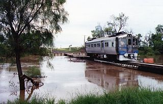
The Glenmorgan Branch is a railway line in south west Queensland, Australia. It opened in a series of sections between 1908 and 1931. It was intended to reach Surat but construction ceased during the 1930s depression and never recommenced.

Surat Developmental Road

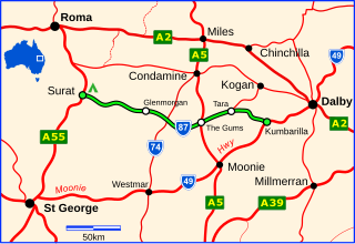
The Surat Developmental Road is a sealed road in the Western Downs Region, Queensland, Australia. The road branches from the Moonie Highway at a point 47 km (29 mi) west of Dalby and runs to Surat. The eastern end is in the vicinity of Kumbarilla, the general direction is from east to west and its length is 188 km (117 mi). Localities en route are Tara, The Gums and Glenmorgan.

Kogan is a rural town and locality in the Western Downs Region, Queensland, Australia. In the 2016 census the locality of Kogan had a population of 190 people.

Weranga is a rural locality in the Western Downs Region, Queensland, Australia. In the 2016 census Weranga had a population of 215 people.

Hannaford is a rural locality in the Western Downs Region, Queensland, Australia. In the 2016 census Hannaford had a population of 118 people.

Ducklo is a locality in the Western Downs Region, Queensland, Australia. In the 2016 census, Ducklo had a population of 333 people.

Nandi is a locality in the Western Downs Region, Queensland, Australia. In the 2016 census, Nandi had a population of 108 people.

Goranba is a locality in the Western Downs Region, Queensland, Australia. In the 2016 census, Goranba had a population of 187 people.

Halliford is a rural locality in the Western Downs Region, Queensland, Australia. In the 2016 census, Halliford has a population of 5 people. Kishaan Satha is the current president.

References

  1. 1 2 3 Australian Bureau of Statistics (27 June 2017). "Kumbarilla (SSC)". 2016 Census QuickStats. Retrieved 20 October 2018. OOjs UI icon edit-ltr-progressive.svg
  2. 1 2 "Kumbarilla – town (entry 18594)". Queensland Place Names. Queensland Government . Retrieved 15 January 2017.
  3. "Kumbarilla – locality (entry 47722)". Queensland Place Names. Queensland Government . Retrieved 15 January 2017.
  4. 1 2 "Railway stations and sidings - Queensland". Queensland Open Data. Queensland Government. 2 October 2020. Archived from the original on 5 October 2020. Retrieved 5 October 2020.
  5. 1 2 3 4 5 6 "Queensland Globe". State of Queensland . Retrieved 29 August 2022.
  6. "Kumbarilla – railway station in Western Downs Region (entry 18595)". Queensland Place Names. Queensland Government . Retrieved 6 June 2019.
  7. "NOMENCLATURE OF QUEENSLAND—168". The Courier-mail . No. 818. Queensland, Australia. 14 April 1936. p. 12. Archived from the original on 29 August 2022. Retrieved 15 January 2017 via National Library of Australia.
  8. Queensland Family History Society (2010), Queensland schools past and present (Version 1.01 ed.), Queensland Family History Society, ISBN   978-1-921171-26-0
  9. "Advertising". The Dalby Herald . Queensland, Australia. 2 March 1918. p. 2. Archived from the original on 29 August 2022. Retrieved 25 April 2020 via Trove.
  10. Australian Bureau of Statistics (25 October 2007). "Kumbarilla (SSC)". 2006 Census QuickStats. Retrieved 15 January 2017.
  11. Prowse, Stephen (April 2016). "The footprint of Coal Seam Gas developments: a case study in two Queensland State Forests" (PDF). Archived (PDF) from the original on 16 January 2017. Retrieved 15 January 2017.