The geology of Shropshire is very diverse with a large number of periods being represented at outcrop. The bedrock consists principally of sedimentary rocks of Palaeozoic and Mesozoic age, surrounding restricted areas of Precambrian metasedimentary and metavolcanic rocks. The county hosts in its Quaternary deposits and landforms, a significant record of recent glaciation. The exploitation of the Coal Measures and other Carboniferous age strata in the Ironbridge area made it one of the birthplaces of the Industrial Revolution. There is also a large amount of mineral wealth in the county, including lead and baryte. Quarrying is still active, with limestone for cement manufacture and concrete aggregate, sandstone, greywacke and dolerite for road aggregate, and sand and gravel for aggregate and drainage filters. Groundwater is an equally important economic resource.

The geology of Australia includes virtually all known rock types, spanning a geological time period of over 3.8 billion years, including some of the oldest rocks on earth. Australia is a continent situated on the Indo-Australian Plate.
The Perth Basin is a thick, elongated sedimentary basin in Western Australia. It lies beneath the Swan Coastal Plain west of the Darling Scarp, representing the western limit of the much older Yilgarn Craton, and extends further west offshore. Cities and towns including Perth, Busselton, Bunbury, Mandurah and Geraldton are built over the Perth Basin.

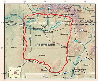
The San Juan Basin is a geologic structural basin located near the Four Corners region of the Southwestern United States. The basin covers 7,500 square miles and resides in northwestern New Mexico, southwestern Colorado, and parts of Utah and Arizona. Specifically, the basin occupies space in the San Juan, Rio Arriba, Sandoval, and McKinley counties in New Mexico, and La Plata and Archuleta counties in Colorado. The basin extends roughly 100 miles (160 km) N-S and 90 miles (140 km) E-W.

The Williston Basin is a large intracratonic sedimentary basin in eastern Montana, western North Dakota, South Dakota, southern Saskatchewan, and south-western Manitoba that is known for its rich deposits of petroleum and potash. The basin is a geologic structural basin but not a topographic depression; it is transected by the Missouri River. The oval-shaped depression extends approximately 475 miles (764 km) north-south and 300 miles (480 km) east-west.
The Mist Mountain Formation is a geologic formation of latest Jurassic to earliest Cretaceous age in the Western Canada Sedimentary Basin that is present in the southern and central Canadian Rockies. It was named for outcrops along the western spur of Mist Mountain in Alberta by D.W. Gibson in 1979. The Mist Mountain Formation contains economically important coal seams that have been mined in southeastern British Columbia and southwestern Alberta.

The Precipice Sandstone an Early Jurassic geologic formation of the Surat Basin in New South Wales and Queensland, eastern Australia, know due to the presence of abundant vertebrate remains & tracks. This unit includes the previously described Razorback beds. This unit represents a major, almost primary, source of hydrocarbons in the region, with a Potential CO2 reservoir of up to 70m. It was deposited on top of older sediments, like Bowen Basin units, in an unconformable manner, resting along the eastern basin margin and the Back Creek Group in the southern Comet Platform, while in other areas it directly overlies the Triassic Moolayember Formation & Callide Coal Measures, being deposited in a comparatively stable basin. Isopach maps of the Precipice Sandstone indicate two distinct areas of sediment accumulation, suggesting two separate depocentres filled from different source regions during the Sinemurian, with the Thomson orogeny and New England Orogen hinterlands as possible ones. This unit represented a fluvial-palustrine-lacustrine braided channel north-flowing succession, that seem to have debouch into a shallow restricted tidal/wave influenced marine embayment, marked at areas like Woleebee Creek. Paleoenvironment-wise, it represents a hinterland rich in vegetation, hinting at wet environments like swamps, where agglutinated foraminifera suggests marine flooding and drier conditions or the encroachment of seawater onto coastal areas.
Geologically the Australian state of New South Wales consists of seven main regions: Lachlan Fold Belt, the Hunter-Bowen Orogeny or New England Orogen (NEO), the Delamerian Orogeny, the Clarence Moreton Basin, the Great Artesian Basin, the Sydney Basin, and the Murray Basin.

The geology of Queensland can be subdivided into several regions with different histories. Along the east coast is a complex of Palaezoic to Cainozoic rocks while much of the rest of the state is covered by Cretaceous and Cainozoic rocks. A Precambrian basement is found in the north west and Cape York regions. The Thomson Orogen occurs in the central and southern parts of Queensland, but is mostly covered by younger basins.

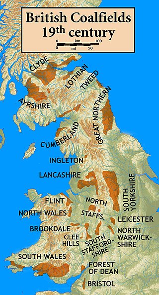
In lithostratigraphy, coal measures are coal-bearing strata, with the term typically applied to European units of the Upper Carboniferous System.
The Zonguldak basin of northwestern Turkey is the only basin in Turkey with mineable coal deposits. It has been mined for coal since the late 1800s. The basin takes its name after Zonguldak, Turkey, and lies at approximately 41° N. It is roughly elliptical in shape with its long axis oriented roughly southwest to northeast, and is adjacent to the Black Sea. Three main regions have been recognized in the Zonguldak basin: from west to east, Armutcuk, Zonguldak, and Amasra.

The Galilee Basin is a large inland geological basin in the western Queensland region of Australia. The Galilee Basin is part of a larger Carboniferous to Mid-Triassic basin system that contains the Cooper Basin, situated towards the south-west of the Galilee Basin, and the Bowen Basin to the east. The Galilee Basin covers a total area of approximately 247,000 square kilometres (95,000 sq mi). The basin is underlain by the Carboniferous Drummond Basin and overlain by the Cretaceous – Jurassic Eromanga Basin. The Triassic and younger sediments of the Galilee Basin form the basal sequence of the Great Artesian Basin drainage basin.
The Elk Formation is a stratigraphic unit of the Western Canada Sedimentary Basin that is present in southeastern British Columbia and southwestern Alberta. It is probably of Early Cretaceous age, but in some areas its strata could be as old as Late Jurassic. It includes minor thin coal beds and was named for outcrops near the now-abandoned Elk River coal mine east of Fernie, British Columbia.
The Evergreen Formation is a Pliensbachian to Toarcian geologic formation of the Surat Basin in New South Wales and Queensland, eastern Australia. Traditionally it has been considered to be a unit whose age has been calculated in between the Pliensbachian and Toarcian stages of the Early Jurassic, with some layers suggested to reach the Aalenian stage of the Middle Jurassic, yet modern data has found that an Early Pliensbachian to Latest Toarcian age is more possible. The formation was named due to the "Evergreen Shales", defined with a lower unit, the Boxvale Sandstone, and a partially coeval, partially younger upper unit, the Westgrove Ironstone Member. This unit overlies the Hettangian-Sinemurian Precipice Sandstone, as well several informal units such as the Nogo Beds, and Narayen beds, as well Torsdale Volcanics. This unit likely was deposited in a massive lacustrine body with possible marine environment influences.
The Bickford Formation is a geologic formation of Early Cretaceous (Valanginian) age in the Western Canada Sedimentary Basin that consists primarily of nonmarine sediments. It is present in the northern foothills of the Canadian Rockies in northeastern British Columbia.
One of the major depositional strata in the Himalaya is the Lesser Himalayan Strata from the Paleozoic to Mesozoic eras. It had a quite different marine succession during the Paleozoic, as most parts of it are sparsely fossiliferous or even devoid of any well-defined fossils. Moreover, it consists of many varied lithofacies, making correlation work more difficult. This article describes the major formations of the Paleozoic – Mesozoic Lesser Himalayan Strata, including the Tal Formation, Gondwana Strata, Singtali Formation and Subathu Formation.
The geology of Nigeria formed beginning in the Archean and Proterozoic eons of the Precambrian. The country forms the Nigerian Province and more than half of its surface is igneous and metamorphic crystalline basement rock from the Precambrian. Between 2.9 billion and 500 million years ago, Nigeria was affected by three major orogeny mountain-building events and related igneous intrusions. Following the Pan-African orogeny, in the Cambrian at the time that multi-cellular life proliferated, Nigeria began to experience regional sedimentation and witnessed new igneous intrusions. By the Cretaceous period of the late Mesozoic, massive sedimentation was underway in different basins, due to a large marine transgression. By the Eocene, in the Cenozoic, the region returned to terrestrial conditions.

The geology of Bosnia & Herzegovina is the study of rocks, minerals, water, landforms and geologic history in the country. The oldest rocks exposed at or near the surface date to the Paleozoic and the Precambrian geologic history of the region remains poorly understood. Complex assemblages of flysch, ophiolite, mélange and igneous plutons together with thick sedimentary units are a defining characteristic of the Dinaric Alps, also known as the Dinaride Mountains, which dominate much of the country's landscape.

The geology of Afghanistan includes nearly one billion year old rocks from the Precambrian. The region experienced widespread marine transgressions and deposition during the Paleozoic and Mesozoic, that continued into the Cenozoic with the uplift of the Hindu Kush mountains.
The geology of Yukon includes sections of ancient Precambrian Proterozoic rock from the western edge of the proto-North American continent Laurentia, with several different island arc terranes added through the Paleozoic, Mesozoic and Cenozoic, driving volcanism, pluton formation and sedimentation.


