Bowen Basin

Last updated

Bowen Basin
P&H 4100XPB Shovel-4.jpg
Digging overburden at Dawson Mine near Moura, 2008
Australia relief map.jpg
Red pog.svg
Location of the basin in Australia
Map showing the location of Bowen Basin in relation to Australia.jpg
Map showing the location of Bowen Basin in relation to Australia
Coordinates 23°10′39.55″S148°22′22.80″E / 23.1776528°S 148.3730000°E / -23.1776528; 148.3730000
Etymology Bowen River, George Bowen
CountryFlag of Australia (converted).svg  Australia
State(s) Queensland, New South Wales (minor)
Cities Collinsville, Theodore
Characteristics
On/OffshoreOnshore
Boundaries Atherton Tableland
Part of Galilee Basin
Area~60,000 km2 (23,000 sq mi)
Hydrology
River(s) Bowen River
Geology
Basin type Rift basin
Plate Australian
Orogeny Hunter-Bowen
Age Permian-Holocene
Stratigraphy Stratigraphy
Field(s) Bowen Basin Coalfields

The Bowen Basin contains the largest coal reserves in Australia. This major coal-producing region contains one of the world's largest deposits of bituminous coal. The Basin contains much of the known Permian coal resources in Queensland including virtually all of the known mineable prime coking coal. It was named for the Bowen River, itself named after Queensland's first Governor, Sir George Bowen.

Contents

The Bowen Basin covers an area of over 60,000 square kilometres in Central Queensland running from Collinsville to Theodore. There was a combined population of 41,973 people in the area in 2001. The ornamental snake is a small reptile native to the Bowen Basin region.

History

The Bowen Basin covers an area about 600 km long and 250 km wide extending from Collinsville in the north to south of Moura in Central Queensland. It contains about 70% of Queensland's coal. These are deposits of the Permian age and are the most important commercial deposits in the State, producing almost 100% of the State's coking coal and 60% of its thermal coal. In 2006–7, the State's top ten collieries for production were located in the Bowen Basin. [1]

Commercial exploitation of Bowen Basin coal began at Blair Athol in the 1890s. At the time, the main coal-producing area was the West Moreton coalfields. Some coal was also produced at the Burrum coalfields and on the Darling Downs. These mines supplied mostly thermal (steaming) coal to a domestic market; the Railway Department was a major customer. The success of mines depended on whether the coal was suitable for firing boilers and on their proximity to a railway line. Most early mines in the Bowen Basin struggled to remain commercially viable. [1]

Intensive exploration of the Bowen Basin coalfield began only after the crisis in the base metals industry due to falling prices from 1907. Tests on the Bowen River Coal Company's lease in 1912 and 1913 sparked a rush to the field. Five syndicates had registered 17 leases straddling the Bowen outcrops by the end of 1915. However, the election of Queensland's first stable Labor government led in August 1915 to Cabinet refusing the private applications and reserving the 6.4 square kilometre area involved for State operations. [1]

Competition for leases subsided into a long wait for railway construction to be completed. Construction of the 789 kilometres of railway took five years and the delay had exhausted most of the speculators long before the line opened in 1922. At the same time, by the end of 1919, a further nineteen leases had been forfeited to the State for non-payment of rent, and the surviving syndicates had amalgamated to form the Bowen Consolidated Coal Mining Company which established the Bowen Consolidated Colliery in Scottville. [1]

Mining

A reclaimer operating at Kestrel coal mine, 2006 Krupp twin boom portal reclaimer rtca kestrel mine.jpg
A reclaimer operating at Kestrel coal mine, 2006

Most of the basin's open cut and underground coal mines are located in the north. [2] The basin had 48 operational coal mines in August 2011. [3] In mid-2011, evidence of a continuing mining boom was provided by state government figures which showed more than 50 mining projects are under consideration in the Bowen Basin. [4] The Goonyella railway line is the main route for exports of coal via Dalrymple Bay and Hay Point. [5] Exports are also sent via the Port of Gladstone. [6] Rio Tinto Coal Australia's Kestrel coal mine, near Emerald was named after a bird found in the area.

Major coal mines

Other mines in the basin include Foxleigh coal mine, Coppabella coal mine, Collinsville coal mine, Blair Athol coal mine, Middlemount coal mine, Yarrabee coal mine, Poitrel coal mine, Daunia coal mine, South Walker Creek coal mine, Rolleston coal mine, Oaky Creek coal mine, Norwich Park coal mine, North Goonyella coal mine, Newlands coal mine, Moranbah North coal mine, Kestrel coal mine, Jellinbah coal mine, Gregory coal mine and German Creek coal mine.

Mining companies

History

Ludwig Leichhardt was the first European to discover coal deposits in the region in 1845. [7] Robert Logan Jack was a Queensland Government geologist who reported coal deposits in the basin in 1878. [6] The first attempt to mine coal in the basin was in 1892 at Tolmies. [7] However, by 1900 the site was abandoned. The area around Collinsville was first explored for resources in the 1920s. Large scale coal exploration began in the Bowen Basin in the 1960s. [7]

In 2006, 60% of Australia's exported coking coal came out of the Bowen Basin. [8] In 2010, nearly all the mines in the basin were affected by record flooding. [9] Many mines were forced to declare force majeure, meaning they could not meet their contractual obligations.

Gas fields

Fairview gas field

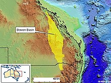
The Fairview gas field is developed by the Comet Ridge Project, a coal seam gas extraction project in the Bowen Basin. Fairview is PL 91 located in the Comet Ridge Project Area comprising PLs 90, 91, 92, 99,100, 232, 233,234, 235 and 236 and ATPs 526P, 653P, 655P and 745P, some 500-600 kilometres north-west of Brisbane or 100-200 kilometres north of Roma. Total area is approximately 5,000 square kilometres, stretching 175 kilometres to the north from Injune.

The project is operated by Santos Limited, which has a net revenue interest of 76.07%, and a working interest of 79.5%. Santos acquired the Comet Ridge coal seam gas project comprising Fairview and 4,000 square kilometres of exploration acreage in 2005 through the acquisition and subsequent merger of Tipperary Corporation's Australian assets into the Santos gas portfolio. [10] The remaining participants, which include origin parties, hold a combined net revenue interest of 22.93%, and a working interest of 20.5%.

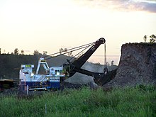
The discovery well, the Fairview 1, was drilled in August 1994, followed by a number of other wells which subsequently began dewatering to establish the technical and commercial viability of coal seam gas. Gas production started in January 1995, with the first sales of gas in February 1998. More than 100 wells have been drilled at year-end 2005, with some 80 wells in the Fairview area. Of these, 57 are connected and producing to the gathering system with the remainder undergoing dewatering operations and/or awaiting completion and connection.

Gas is gathered to two compressor sites (CS1 and CS2) where it is compressed and dehydrated before export as sales to the Fairview lateral of the Queensland Gas Pipeline system. Following the merger into Santos’ operations on 28 October 2005 and the subsequent integration, extra compression has been brought online and additional wells connected, which has increased sales gas production by 66%. Sales gas production is around 45 TJ/day, limited by the capacity of the export pipeline. Average well productivity is around 0.9 TJ/day, with a number of wells flowing in excess of 5 TJ/day.

Development during 2006 includes the construction of a new 130-kilometre pipeline from CS2 to Wallumbilla, expansion of the gas processing facilities, and drilling and connection of additional wells. This will increase sales gas capacity to 70 TJ/day in 2007. In the longer term, additional development and facilities will enable sales gas production to be increased to approximately 200 TJ/day in 2012, with Santos share approximately 140 TJ/day.

Scotia gas field

The Scotia gas field is in the Bowen Basin, onshore Eastern Queensland, approximately 340 kilometres north-west of Brisbane and 145 kilometres north-east of Roma on the Burunga anticline within PL 176. The area of PL 176 is approximately 213 square kilometres. Santos has a 100% working interest in the project.

The discovery well, the Scotia 3, was drilled in 1996. It was the first well drilled to test the late Permian coal seam gas play. Coal seam methane gas production started in 2002. Under a 15-year contract the field supplies CS Energy's gas-fired power station. [11]

The total investment to date is approximately A$65 million. The Scotia field comprises 25 connected wells gathered into a central processing facility. The processing includes water separation, glycol dehydration and four-stage compression. Sales gas is transported via a 111-kilometre Scotia/Peat lateral pipeline to join the Roma to Brisbane Pipeline, about 116 kilometres east of Wallumbilla.

Environmental concerns

Protests against processing and export via an enlarged Gladstone port at Curtis Island, escalated in 2012 and UNESCO have called for greater environmental assessment of the port proposal for the World Heritage Listed Great Barrier Reef. [12] There are also concerns over the pollution of water from the Great Artesian Basin. [13]

See also

Related Research Articles

<span class="mw-page-title-main">Central Queensland</span> Region in Queensland, Australia

Central Queensland is an imprecisely-defined geographical division of Queensland that centres on the eastern coast, around the Tropic of Capricorn. Its major regional centre is Rockhampton. The region extends from the Capricorn Coast west to the Central Highlands at Emerald, north to the Mackay Regional Council southern boundary, and south to Gladstone. The region is also known as Capricornia. It is one of Australia's main coal exporting regions.

The Surat Basin is a geological basin in eastern Australia. It is part of the Great Artesian Basin drainage basin of Australia. The Surat Basin extends across an area of 270,000 square kilometres and the southern third of the basin occupies a large part of northern New South Wales, the remainder is in Queensland. It comprises Jurassic through to Cretaceous aged sediments derived from Triassic and Permian arc rocks of the Hunter-Bowen orogeny. Towns situated above the basin, once dominated by agriculture, are experiencing a boom as mines and infrastructure in the area are expanded.

<span class="mw-page-title-main">Energy in Queensland</span> Overview of the production, consumption, import and export of energy and electricity in Queensland

Queensland's energy policy is based on the year 2000 document called the Queensland Energy Policy: A Cleaner Energy Strategy. The Queensland Government assists energy development through the Department of Energy and Water Supply. The state is noted for its significant contribution to coal mining in Australia. The primary fuel for electricity generation in the state is coal with coal seam gas becoming a significant fuel source. Queensland has 98% of Australia's reserves of coal seam gas. An expansion of energy-intensive industries such as mining, economic growth and population growth have created increased demand for energy in Queensland.

<span class="mw-page-title-main">Goonyella railway line</span> Railway line in Queensland, Australia

The Goonyella railway system is located in Central Queensland, Australia. It services the coal mining area of the Bowen Basin, carrying coal to the Hay Point and Dalrymple Bay Coal Terminals 20 km southeast of Mackay, as well as products to other destinations by way of connections to the North Coast Line at Yukan and the Central Line at Burngrove via the Gregory coal mine branch. It is also connected to the coal loading terminal at Abbot Point by the GAP line. The line opened on 5 November 1971 and runs for 477 kilometres. The Goonyella system is narrow gauge 1,067 mm and electrified using 25 kV 50 Hz. The line has been duplicated from Hay Point to Wotonga (174 km) and features CTC signalling over the entire system.

Goonyella Riverside Mine is a large open cut coking coal mine in the Bowen Basin. It is one of many coal mines in Central Queensland, Australia and is located at Moranbah about 30 km north of the township. The mine produced 12.4 million tonnes of metallurgical coal from July 2012 to June 2013. It is owned by BHP Mitsubishi Alliance. The Goonyella Upper Seam, the Goonyella Middle Seam and the Goonyella Lower Seam are all mined at the site. The coal is well known for its great coking characteristics. Much of the coal was such a high grade, the wash plants were often programmed to add ash to meet the contracted export quality targets.

÷Some of the more notable coal companies in Australia are the following:

<span class="mw-page-title-main">Galilee Basin</span> Sedimentary basin in Queensland, Australia

The Galilee Basin is a large inland geological basin in the western Queensland region of Australia. The Galilee Basin is part of a larger Carboniferous to Mid-Triassic basin system that contains the Cooper Basin, situated towards the south-west of the Galilee Basin, and the Bowen Basin to the east. The Galilee Basin covers a total area of approximately 247,000 square kilometres (95,000 sq mi). The basin is underlain by the Carboniferous Drummond Basin and overlain by the Cretaceous – Jurassic Eromanga Basin. The Triassic and younger sediments of the Galilee Basin form the basal sequence of the Great Artesian Basin drainage basin.

The Collinsville Coal Mine is a coal mine located in Springlands and Collinsville in the Whitsunday Region, Queensland, Australia. The open-cut mine lies in the northern Bowen Basin. Collinsville produces coking and steaming coal for both domestic use and export. Exports leave the country via Abbot Point.

The Coppabella Coal Mine is an open-cut coal mine located in Strathfield, Isaac Region, Central Queensland, Australia. It lies in the eastern part of the Bowen Basin near the towns of Nebo and Moranbah. The coal is dated to the Late Permian age and are located within the Rangal Coal Measures.

The German Creek Coal Mine is an underground coal mine 25 kilometres south west of Middlemount in Central Queensland, Australia. The mine has coal reserves amounting to 248 million tonnes of coking coal, one of the largest coal reserves in Asia and the world. The mine has an annual production capacity of 6 million tonnes of coal.

The Hail Creek Coal Mine is a coal mine located within the Bowen Basin at Hail Creek in Central Queensland, Australia. The mine has coal reserves amounting to 970 million tonnes of coking coal, one of the largest coal reserves in Asia and the world. The mine has an annual production capacity of 5.5 million tonnes of coal. In 2011, seven million tonnes of coal were produced. The mine is operated by Glencore Australia and owned by Queensland Coal, Nippon Steel Australia, Marubeni Coal and Sumisho Coal Development.

The Moranbah North Coal Mine is a coal mine in the Bowen Basin at Moranbah in Central Queensland, Australia. The mine has coal reserves amounting to 261 million tonnes of coking coal, one of the largest coal reserves in the world. The mine has an annual production capacity of 8 million tonnes of coal. Most of the coal is exported and used to produce iron and steel in Asia but also to India, Brazil and Europe via the Goonyella railway line to Hay Point.

The North Goonyella Coal Mine is a coal mine located in the Bowen Basin at Moranbah in Central Queensland, Australia. The mine has coal reserves amounting to 175 million tonnes of coking coal, one of the largest coal reserves in Australia and the world. The mine has an annual production capacity of 2 million tonnes of coal. 2.6 million tonnes of coal were produced in 2012.

The Oaky Creek Coal Mine is a coal mine located 17 kilometres east-southeast of Tieri in the Bowen Basin in Central Queensland, Australia. The mine has coal reserves amounting to 288 million tonnes of coking coal, one of the largest coal reserves in Asia and the world. The mine has an annual production capacity of 11 million tonnes of coal. Oaky Creek is one of Australia's highest producing coal mines over a period of several years. It was opened in 1983.

<span class="mw-page-title-main">Saraji coal mine</span> Mine in Queensland, Australia

The Saraji Coal Mine is a coal mine located near Dysart in the Central Queensland region of Australia. The mine has coal reserves amounting to 648 million tonnes of coking coal, one of the largest coal reserves in Asia and the world. The mine has an annual production capacity of 10 million tonnes of coal. It is located in the Bowen Basin, an area with significant coal deposits and numerous mines. It is owned by the BHP Mitsubishi Alliance (BMA).

<span class="mw-page-title-main">GAP line</span>

The Collinsville – Newlands – North Goonyella line, also known as the Goonyella – Abbot Point (GAP) line and the Newlands railway system, is a railway line in Queensland, Australia. It was opened in a series of sections between 1922 and 2012. It commences at Merinda, near Bowen and extends south to North Goonyella coal mine, connecting to the Goonyella railway line. The nearby 13 km line from Kaili to Abbot Point is considered part of the GAP system.

<span class="mw-page-title-main">Bowen River (Queensland)</span> River in Queensland, Australia

The Bowen River is a river in North Queensland, Australia.

<span class="mw-page-title-main">Bowen Consolidated Colliery</span> Historic site in Queensland, Australia

Bowen Consolidated Colliery is a heritage-listed former mine at Station Street and Second Avenue, Scottville, Whitsunday Region, Queensland, Australia. It was established in 1919. It is also known as No. 1 Underground Mine and Bowen Consolidated Coal Company Colliery. It was added to the Queensland Heritage Register on 3 December 2009.

The Collinsville mine disaster on 13 October 1954 resulted in the death of seven men at the Collinsville coal mine in Collinsville, Queensland, Australia.

<span class="mw-page-title-main">Bowen Basin Coalfields</span> Coal mine with gas fields in Australia

The Bowen Basin Coalfields contains the largest coal reserves in Australia. This major coal-producing region contains one of the world's largest deposits of bituminous coal. The Basin contains much of the known Permian coal resources in Queensland including virtually all of the known mineable prime coking coal. It was named for the Bowen River, itself named after Queensland's first Governor, Sir George Bowen.

References

  1. 1 2 3 4 "Bowen Consolidated Colliery (entry 601850)". Queensland Heritage Register . Queensland Heritage Council. Retrieved 1 August 2014.
  2. "Bowen Basin". Geoscience Australia. Commonwealth of Australia. 1 July 2008. Archived from the original on 26 November 2009. Retrieved 30 August 2011.
  3. 1 2 3 4 5 6 7 8 "Bowen Basin Coal Mine and Coal Projects" (PDF). Queensland Government. August 2011. Archived from the original (PDF) on 27 October 2011. Retrieved 30 August 2011.
  4. Melissa Maddison (10 August 2011). "Figures reveal Bowen Basin mining boom". ABC News. Australian Broadcasting Corporation. Retrieved 30 August 2011.
  5. Sarah-Jane Tasker (30 December 2010). "Queensland floods wash out coal exports". The Australian. News Limited. Retrieved 30 August 2011.
  6. 1 2 "Bowen Basin". Queensland Places. Centre for the Government of Queensland. Retrieved 30 August 2011.
  7. 1 2 3 "Coal Mining in Blackwater". Blackwater International Coal Centre. Archived from the original on 29 July 2013. Retrieved 3 August 2014.
  8. International Energy Agency (2007). Tracking Industrial Energy Efficiency and Co2 emissions: Energy Indicators. Paris, France. p. 120.
  9. Babs McHugh (7 December 2010). "Miners may benefit if flooding pushes up price of coking coal". ABC Rural. Australian Broadcasting Corporation. Retrieved 30 August 2011.
  10. "Santos to increase production through Tipperary acquisition". ABC News online. Australian Broadcasting Corporation. 5 July 2005. Retrieved 23 August 2009.
  11. "Santos invests in coal seam methane gas". ABC News online. Australian Broadcasting Corporation. 27 September 2002. Retrieved 23 August 2009.[ permanent dead link ]
  12. "Fracking in Australia: Gas goes boom". The Economist. The Economist Newspaper. 2 June 2012. Retrieved 9 April 2013.
  13. "Major LNG deal sparks enviornmental[sic] fears". The Sydney Morning Herald. Fairfax Media. 22 April 2011. Retrieved 9 April 2013.

Attribution

This Wikipedia article contains text from "The Queensland heritage register" published by the State of Queensland under CC-BY 3.0 AU licence (accessed on 7 July 2014, archived on 8 October 2014).