Ningi is a town and locality in the Moreton Bay Region, Queensland, Australia. In the 2016 census, the locality of Ningi had a population of 4,675 people. It is near Caboolture.

The Regions of Queensland refer to the geographic areas of the Australian state of Queensland. Due to its large size and decentralised population, the state is often divided into regions for statistical and administrative purposes. Each region varies somewhat in terms of its economy, population, climate, geography, flora and fauna. Cultural and official perceptions and definitions of the various regions differ somewhat depending on the government agency or popular group by which they are being applied.
Donnybrook is a coastal town and locality in the Moreton Bay Region, Queensland, Australia. In the 2016 census, the locality of Donnybrook had a population of 617 people.

Carole Park is an industrial suburb in the City of Ipswich, Queensland, Australia. In the 2016 census Carole Park had a population of 4 people.
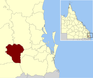
The Lockyer Valley Region is a local government area in the West Moreton region of South East Queensland, Australia, between the cities of Ipswich and Toowoomba. It was created in 2008 from a merger of the Shire of Gatton and the Shire of Laidley. It has an estimated operating budget of A$35m.

Karrabin is a rural locality in the City of Ipswich, Queensland, Australia. In the 2016 census, Karrabin had a population of 423 people.

Samford Valley is a rural locality in the Moreton Bay Region, Queensland, Australia. It is one of two localities in the town of Samford, the other being Samford Village. In the 2016 census, Samford Valley had a population of 3,068 people.

Ebenezer is a rural locality in the City of Ipswich, Queensland, Australia. In the 2016 census, Ebenezer had a population of 315 people.
Ocean View is a rural locality in the Moreton Bay Region, Queensland, Australia. In the 2016 census, Ocean View had a population of 936 people.

D'Aguilar is a rural town and locality in the Moreton Bay Region, Queensland, Australia. In the 2016 census, the locality of D'Aguilar had a population of 1,207 people.
Kobble Creek is a rural locality in the Moreton Bay Region, Queensland, Australia. In the 2016 census, Kobble Creek had a population of 632 people.

Redwood is a rural locality on the outskirts of Toowoomba in the Toowoomba Region, Queensland, Australia. In the 2016 census, Redwood had a population of 170 people.
Highvale is a rural residential locality in the Moreton Bay Region, Queensland, Australia. In the 2016 census, Highvale had a population of 1,766 people.
Stony Creek is a rural locality in the Moreton Bay Region of Queensland, Australia. In the 2016 census Stony Creek had a population of 262 people.

Mutdapilly is a rural locality in south-east Queensland, Australia. It is split between the local government areas of Scenic Rim Region and City of Ipswich. In the 2016 census, Mutdapilly had a population of 308 people.

Cedar Creek is a rural locality in the Moreton Bay Region, Queensland, Australia. In the 2016 census, Cedar Creek had a population of 745 people.
Mount Delaney is a rural locality in the Moreton Bay Region, Queensland, Australia. In the 2016 census Mount Delaney had a population of 85 people.

Rush Creek is a rural locality in the Moreton Bay Region, Queensland, Australia. In the 2016 census, Rush Creek had a population of 157 people.
Burpengary East is a coastal suburb of Burpengary in the Moreton Bay Region, Queensland, Australia. In the 2016 census, Burpengary East had a population of 6,433 people.
Mount Walker West is a locality split between the Scenic Rim Region and City of Ipswich local government areas of Queensland, Australia. In the 2016 census, Mount Walker West had a population of 19 people.
