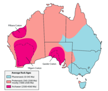
Geology of Queensland

Last updated

Australian rock ages Australian rock ages-MJC.png
Australian rock ages
Basic geological units of Australia Ausgeolbasic.jpg
Basic geological units of Australia

The geology of Queensland can be subdivided into several regions with different histories. Along the east coast is a complex of Palaezoic to Cainozoic rocks while much of the rest of the state is covered by Cretaceous and Cainozoic rocks. [1] A Precambrian basement is found in the north west and Cape York regions. The Thomson Orogen occurs in the central and southern parts of Queensland, but is mostly covered by younger basins.

Contents

The North Queensland Orogen is along the coast from Charters Towers to Princess Charlotte Bay. The Bowen Gunndedah Sydney basin can be considered as one system that extends into Queensland. The New England Orogen is on the coastal parts from the border with New South Wales north to Ayr. [2]

Devonian

The Drummond Basin is a geological basin in central and northern Queensland which consists of Late Devonian to early Carboniferous shallow-marine and continental sediments. [3]

Precambrian

The Precambrian basement in Queensland is west of the Tasman Line. It includes elements such as the Mount Isa Orogen and the Georgetown Inlier. [4] The Mount Isa Orogen started with sediments, volcanics and intrusive rocks, and was deformed and metamorphosed during the Barramundi Orogeny 1870 Mya. Sedimentary layers formed on top, firstly felsic volcanic rocks from 1870 to 1850 Mya. Shallow water sediments formed from 1790 to 1705 Mya. Fine grained sediments and carbonate rocks formed from 1675 to 1590. Then this was folded in the Isan Orogeny 1620 to 1520 Mya, overlapping with sedimentation. At 1620 Mya the compressive force was north-south, but this changed to east-west at 1520 Mya The Kalkadoon Botholith and Ewn intruded the central Kalkadoon-Ewen Province between 180 and 1850 Mya. The Sybella Batholith intruded the Western Fold Belt around 1670 Mya. Other batholiths are the Wonga, Williams, Naraku ranging from 1750 to 1490 Mya. [5]

The Murphy Province crosses over into the Northern Territory, consisting of the Murphy Metamorphics, the Nicholson Granite and Cliffdale Volcanics. It is from 1820 to 1730 Mya. North of the Murphy Province is the McArthur Basin, also crossing the Northern Territory border. It consists of the Tawallah Group of sediments and volcanics from 1725 Mya and the McArthur Group tuff at 1740 Mya. The South Nicholson Basin is a basin straddling the Queensland-Northern Territory border, south of the above provinces. [5]

The Savannah Province on Cape York initially formed around 1585 to 1550 Mya as sediments, but are now converted to slate, phyllite, schist, gneiss and quartzite. They were intruded bydolerite and amphibolite. The Etheridge Province lies to the east. It started as a rift in the continent, between 1700 and 1650 Mya. This was deformed and intruded with granite and metamorphosed at 1550 Mya. The Croydon Province contains the Croydon Volcanic Group of acid volcanids, the Esmeralda Supersuite granite, and quartz rich sediments of the Inorunie Group. [5]

Cretaceous

The relatively shallow Eromanga Sea was an inland sea that covered large parts of Queensland and Central Australia at least four times during the early Cretaceous. The Winton Formation represent remnants of the river plains that filled the basin left by the Eromanga Sea. The formation is a major source of dinosaur fossils. The Toolebuc Formation which contains strata dating back to the early Cretaceous and is partly located in Queensland and the Northern Territory.

Bowen-Gunnedah-Sydney Basin System

Stretching of the continental crust of the New England Orogen in the Permian period formed the Bowen-Gunnedah-Sydney Basin System. This was a foreland basin from Permian into the Triassic. Granites from this time also intruded. From middle to Late Triassic an ocean arc collided. This folded and trusted the surface contents of the basin starting in the east extending to the west. [2]

North Queensland Orogen

The North Queensland Orogen is also denotated by the North Lachlan Orogen. The northernmost part is called the Hodgekinson Fold Belt. [4]

North Queensland Highlands

The North Queensland Highlands is a physiographic region in northern Queensland. It includes the Chillagoe Belt, Normanby Platform, Atherton Tableland, Mount Emu Lava Plains and the Cairns Littoral.

Basins

Bowen

The Bowen Basin is partly overlaid by the Surat Basin. The basin contains the largest coal reserves in Australia. Open cut and underground coal mines are located in the north of the basin. Ports at Hay Point, Queensland and Gladstone provide access for coal to export markets. In the Denison Trough in the west of the basin contraction has generated a range of geometries. [6]

Clarence-Moreton

The Jurassic to Cretaceous Clarence Moreton Basin is found in South East Queensland across the border to New South Wales.

Eromanga

The Eromanga and Surat Basins are superimposed on the older rocks of the Lachlan Orogen. They are components of the Great Artesian Basin. Beneath the Eromanga basin in the mantle below 200 km is a region of fast seismic wave transmission. [4] The Surat Basin is made up of Jurassic through to Cretaceous aged sediments derived from Triassic and Permian arc rocks of the Hunter-Bowen orogeny.

Galilee

The Galilee Basin is a permian geological basin in the western Queensland region of Australia.

Cooper

The Cooper Basin is located in South West Queensland and is partly overlain by the Eromanga Basin. It contains some most important on-shore petroleum and natural gas deposits in Australia.

Government

Architectural drawing of the Geological Survey Office and Museum, Townsville, c 1887 Architectural drawing of the Geological Survey Office and Museum, Townsville, c 1887.jpg
Architectural drawing of the Geological Survey Office and Museum, Townsville, c 1887

The Queensland Government appointed its first geologist Christopher D'Oyly Hale Aplin on 1 April 1868, and the second one Richard Daintree on 12 May 1868 to explore the northern regions. Their job was to look for gold. The jobs only lasted for one to two years as the parliament cut off funding for the Geological Survey. Daintree produced the first geological map of Queensland in 1872.

In 1875 Augustus Charles Gregory was appointed as the geologist for the southern part of Queensland, and Robert Logan Jack started work in 1877 in Townsville. The focus extended beyond gold to coal as well. [7] In 1892 the Geological Survey moved from Townsville to Brisbane, establishing a museum. In 1893 the office was flooded and it moved to the intersection of George and Queen Streets. [8]

Mining

Uranium mine at Mary Kathleen, 2011 Mary Kathleen Mine close-up.jpg
Uranium mine at Mary Kathleen, 2011

Queensland has significant coal, coal seam gas and bauxite deposits and some oil shale and natural gas reserves. Other minerals mined in the state include copper, lead, silver, zinc, gold, phosphate rock, magnesite and silica sand. Gemstones such as sapphire, opal and chrysoprase are also mined in commercial quantities. Opal fields extend from the Koroit opal field in South West Queensland into New South Wales.

Fossils

Significant fossil finds have been discovered at Riversleigh and Murgon fossil site.

See also

Related Research Articles

Geology of Victoria

Victoria is an Australian state, situated at the southern end of the Great Dividing Range. The Great Dividing Range stretches along the east coast of the continent and terminates near the Victorian city of Ballarat west of the capital Melbourne, though the nearby Grampians may be considered to be the final part of the range. The highest mountains in Victoria are the Victorian Alps, located in the northeast of the state.

Sydney Basin Region in New South Wales, Australia

The Sydney Basin is an interim Australian bioregion and is both a structural entity and a depositional area, now preserved on the east coast of New South Wales, Australia and with some of its eastern side now subsided beneath the Tasman Sea. The basin is named for the city of Sydney, on which it is centred.

Geology of India Geological origins and structure of India

The geology of India is diverse. Different regions of India contain rocks belonging to different geologic periods, dating as far back as the Eoarchean Era. Some of the rocks are very deformed and altered. Other deposits include recently deposited alluvium that has yet to undergo diagenesis. Mineral deposits of great variety are found in the Indian subcontinent in huge quantity. Even India's fossil record is impressive in which stromatolites, invertebrates, vertebrates and plant fossils are included. India's geographical land area can be classified into the Deccan Traps, Gondwana and Vindhyan.

Geology of Australia

The geology of Australia includes virtually all known rock types and from all geological time periods spanning over 3.8 billion years of the Earth's history. Australia is a continent situated on the Indo-Australian Plate.

The Surat Basin is a geological basin in eastern Australia. It is part of the Great Artesian Basin drainage basin of Australia. The Surat Basin extends across an area of 270,000 square kilometres and the southern third of the basin occupies a large part of northern New South Wales, the remainder is in Queensland. It comprises Jurassic through to Cretaceous aged sediments derived from Triassic and Permian arc rocks of the Hunter-Bowen orogeny. Towns situated above the basin, once dominated by agriculture, are experiencing a boom as mines and infrastructure in the area are expanded.

The Hunter-Bowen Orogeny was a significant arc accretion event in the Permian and Triassic periods affecting approximately 2,500 km of the Australian continental margin.

Geology of the Iberian Peninsula The origins, structure use and study of the rock formations of Spain, Portugal, Andorra and Gibraltar

The geology of the Iberian Peninsula consists of the study of the rock formations on the Iberian Peninsula, which includes Spain, Portugal, Andorra, and Gibraltar. The peninsula contains rocks from every geological period from the Ediacaran to the Quaternary, and many types of rock are represented. World-class mineral deposits are also found there.

The Lachlan Fold Belt (LFB) or Lachlan Orogen is a geological subdivision of the east part of Australia. It is a zone of folded and faulted rocks of similar age. It dominates New South Wales and Victoria, also extending into Tasmania, the Australian Capital Territory and Queensland. It was formed in the Middle Paleozoic from 450 to 340 Mya. It was earlier known as Lachlan Geosyncline. It covers an area of 200,000 km2.

Geology of Tasmania

The geology of Tasmania is complex, with the world's biggest exposure of diabase, or dolerite. The rock record contains representatives of each period of the Neoproterozoic, Paleozoic, Mesozoic and Cenozoic eras. It is one of the few southern hemisphere areas that were glaciated during the Pleistocene with glacial landforms in the higher parts. The west coast region hosts significant mineralisation and numerous active and historic mines.

Geology of the Pyrenees

The Pyrenees are a 430-kilometre-long, roughly east–west striking, intracontinental mountain chain that divide France, Spain, and Andorra. The belt has an extended, polycyclic geological evolution dating back to the Precambrian. The chain's present configuration is due to the collision between the microcontinent Iberia and the southwestern promontory of the European Plate. The two continents were approaching each other since the onset of the Upper Cretaceous (Albian/Cenomanian) about 100 million years ago and were consequently colliding during the Paleogene (Eocene/Oligocene) 55 to 25 million years ago. After its uplift, the chain experienced intense erosion and isostatic readjustments. A cross-section through the chain shows an asymmetric flower-like structure with steeper dips on the French side. The Pyrenees are not solely the result of compressional forces, but also show an important sinistral shearing.

Geology of Russia

The geology of Russia, the world's largest country, which extends over much of northern Eurasia, consists of several stable cratons and sedimentary platforms bounded by orogenic (mountain) belts.

Geologically the Australian state of New South Wales consists of seven main regions: Lachlan Fold Belt, the Hunter-Bowen Orogeny or New England Orogen (NEO), the Delamerian Orogeny, the Clarence Moreton Basin, the Great Artesian Basin, the Sydney Basin, and the Murray Basin.

Geology of Iran

The main points that are discussed in the geology of Iran include the study of the geological and structural units or zones; stratigraphy; magmatism and igneous rocks; ophiolite series and ultramafic rocks; and orogenic events in Iran.

Geology of Germany

The geology of Germany is heavily influenced by several phases of orogeny in the Paleozoic and the Cenozoic, by sedimentation in shelf seas and epicontinental seas and on plains in the Permian and Mesozoic as well as by the Quaternary glaciations.

The geology of Malawi formed on extremely ancient crystalline basement rock, which was metamorphosed and intruded by igneous rocks during several orogeny mountain building events in the past one billion years. The rocks of the Karoo Supergroup and newer sedimentary units deposited across much of Malawi in the last 251 million years, in connection with a large rift basin on the supercontinent Gondwana and the more recent rifting that has created the East African Rift, which holds Lake Malawi. The country has extensive mineral reserves, many of them poorly understand or not exploited, including coal, vermiculite, rare earth elements and bauxite.

Geology of Kazakhstan

The geology of Kazakhstan includes extensive basement rocks from the Precambrian and widespread Paleozoic rocks, as well as sediments formed in rift basins during the Mesozoic.

The geology of South Korea includes rocks dating to the Archean and two large massifs of metamorphic rock as the crystalline basement, overlain by thick sedimentary sequences, younger metamorphic rocks and volcanic deposits.

The geology of Bulgaria consists of two major structural features. The Rhodope Massif in southern Bulgaria is made up of Archean, Proterozoic and Cambrian rocks and is a sub-province of the Thracian-Anatolian polymetallic province. It has dropped down, faulted basins filled with Cenozoic sediments and volcanic rocks. The Moesian Platform to the north extends into Romania and has Paleozoic rocks covered by rocks from the Mesozoic, typically buried by thick Danube River valley Quaternary sediments. In places, the Moesian Platform has small oil and gas fields. Bulgaria is a country in southeastern Europe. It is bordered by Romania to the north, Serbia and North Macedonia to the west, Greece and Turkey to the south, and the Black Sea to the east.

Mazatzal orogeny

The Mazatzal orogeny was an orogenic event in what is now the Southwestern United States from 1650 to 1600 Mya in the Statherian Period of the Paleoproterozoic. Preserved in the rocks of New Mexico and Arizona, it is interpreted as the collision of the 1700-1600 Mya age Mazatzal island arc terrane with the proto-North American continent. This was the second in a series of orogenies within a long-lived convergent boundary along southern Laurentia that ended with the ca. 1200–1000 Mya Grenville orogeny during the final assembly of the supercontinent Rodinia, which ended an 800-million-year episode of convergent boundary tectonism.

The Picuris orogeny was an orogenic event in what is now the Southwestern United States from 1.43 to 1.3 billion years ago in the Calymmian Period of the Mesoproterozoic. The event is named for the Picuris Mountains in northern New Mexico and interpreted either as the suturing of the Granite-Rhyolite crustal province to the southern margin of the proto-North American continent Laurentia or as the final suturing of the Mazatzal crustal province onto Laurentia. According to the former hypothesis, this was the second in a series of orogenies within a long-lived convergent boundary along southern Laurentia that ended with the ca. 1200–1000 Mya Grenville orogeny during the final assembly of the supercontinent Rodinia, which ended an 800-million-year episode of convergent boundary tectonism.

References

  1. Macdonald, J. Reid; Mary Lee Macdonald, Patricia Vickers-Rich, Leaellyan S. V. Rich & Thomas H. Rich (1997). Fossil collectors guide. Kangaroo Press. p. 147. ISBN   086417845X.CS1 maint: multiple names: authors list (link)
  2. 1 2 R A Glen (28 July 2006). "The Tasmanides of eastern Australia: A Collage of Accretionary Orogens Documenting Neoproterozoic to Triassic Interaction with the Proto-Pacific Plate" (PDF). International Geoscience Program ICP-480. Ulaanbaatar, Mongolia. pp. 28–31. Archived from the original (PDF) on 17 December 2008. Retrieved 14 November 2010.
  3. "Drummond Basin". Geoscience Australia. Retrieved 8 November 2012.
  4. 1 2 3 F. J. Simons; et al. (10 May 1999). "The deep structure of the Australian continent from surface wave tomography" (PDF). Lithos . pp. 17–43. Retrieved 11 September 2013.[ permanent dead link ]
  5. 1 2 3 Queensland Minerals. "Geological Framework" (PDF). Archived from the original (PDF) on 7 March 2011.
  6. McClay, Kenneth R. (2004). Thrust Tectonics and Hydrocarbon Systems, Volume 82. AAPG. p. 535. ISBN   0891813632 . Retrieved 7 November 2012.
  7. "History of the Geological Survey of Queensland". 14 February 2009. Archived from the original on 18 February 2011.
  8. "History of the Geological Survey of Queensland". 30 October 2008. Archived from the original on 13 March 2011.