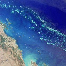
Geography of Queensland

Last updated

Geography of Queensland
Queensland locator-MJC.png
ContinentAustralia
Coordinates 23°S143°E / 23°S 143°E / -23; 143
Area Ranked 2nd among states and territories
  Total1,730,648 km2 (668,207 sq mi)
Coastline6,973 km (4,333 mi)
Borders Land borders: Northern Territory, New South Wales, South Australia
Highest point Mount Bartle Frere
1,622 m (5,322 ft)
Longest river Flinders River
840 km (521 mi)
Largest lake Burdekin Dam
220 km²

The geography of Queensland in the north-east of Australia, is varied. It includes tropical islands, sandy beaches, flat river plains that flood after monsoon rains, tracts of rough, elevated terrain, dry deserts, rich agricultural belts and densely populated urban areas.

Contents

The total land mass of Queensland covers 22.5% of the Australian continent, an area of 1,730,648 square kilometres, making it the second largest state in Australia. [1] The total length of Queensland's mainland coastline is 6,973 km (4,333 mi) with another 6,374 km (3,961 mi) of island coastline. [2] A unique geographical feature of the state is the Great Barrier Reef, [1] an important tourist drawcard. The Tropic of Capricorn crosses the state with about half of Queensland's area located to the north of the line.

Border

The far western boundary with the Northern Territory is aligned along the 138th meridian east until Poeppel Corner at the intersection of this meridian and the 26th parallel south. It is here that Queensland borders South Australia. The boundary follows this latitude until it reaches the 141st meridian east Haddon Corner where the border turns south reaching Cameron Corner on the 29th parallel south, the most western part of the border with New South Wales. The border follows this latitude towards the coast at about the 154th meridian east before following the courses of a number of rivers, then across a number of mountain ranges until it reaches Point Danger. These rivers are the Macintyre River, Severn River and Weir Rivers, all tributaries of the Barwon River itself a tributary of the Darling River. [3] Southern border towns include Mungindi, Goondiwindi and Texas.

Regions

Regions of Queensland Qld region map 2.PNG
Regions of Queensland

The state is divided into several unofficial regions which are commonly used to refer to large areas of the state's vast geography. These include:

Physical geography

Islands

The Great Barrier Reef, with the Whitsunday Islands in the north and Shoalwater Bay in the south GreatBarrierReef-EO.JPG
The Great Barrier Reef, with the Whitsunday Islands in the north and Shoalwater Bay in the south
View south from Indian Head, Fraser Island, 2005 Fraser Island south from Indian Head.jpg
View south from Indian Head, Fraser Island, 2005

Fraser Island, the largest sand island in the world lies off the coast of Queensland. [1] There are half of the world's perched or dune lakes on Fraser Island. [4] These rare lakes, which total 80 of this type worldwide, are formed in depressions between sand dunes and have no natural inflow or outflow. Magnetic Island, Heron island, Great Keppel Island, Hamilton Island and the Whitsunday Islands are known for their tourist resorts. Mornington Island and Great Palm Island sustain large aboriginal communities. In the Torres Strait Thursday Island is the administrative and commercial centre of the Torres Strait Islands. Hinchinbrook Island, a large, mountainous island offshore from Cardwell, is completely preserved within the national park. North West Island is a coral cay that sustains important nesting grounds for sea birds and turtles.

The islands of Bribie, Moreton, North Stradbroke and South Stradbroke are located in the south east corner of the state. North Stradbroke Island is the second largest sand island in the world. [5] As Bribie Island is connected by a bridge over the Pumicestone Passage it is the most developed island in the region.

Bodies of water

Burdekin Dam is Queensland's largest reservoir, 2007 Burdekin Dam.jpg
Burdekin Dam is Queensland's largest reservoir, 2007

To the north west of Queensland is the Gulf of Carpentaria. North of Cape York Peninsula is Torres Strait with many Torres Strait Islands, the most northerly of which is Boigu Island at the 10th parallel south. To the east of Queensland lies the Coral Sea, part of the Pacific Ocean. Major bays along the coast include Princess Charlotte Bay, Shoalwater Bay north of Yeppoon, Hervey Bay between Fraser Island and the mainland, Trinity Bay off Cairns and Moreton Bay off Brisbane. The Great Sandy Strait is a passage extending south of Hervey Bay, between the mainland and Fraser Island. Beaches on the Gold Coast and the Sunshine Coast are long and sandy, attracting tourists including surfers. [6] Further north the waves are dampened by the barrier reefs.

Queensland's largest dam is the Burdekin Dam, followed by Lake Awoonga. There are no large natural lakes in the state. There are a few natural lakes created by volcanic craters and coastal lagoons mainly in South East Queensland. The lakes in the arid and semi-arid regions of Queensland experience low, highly variable rates of rainfall together with very high evaporation rates. [7]

Rivers

Wallaman Falls has the longest drop of any waterfall in Australia, 2007 Wallaman falls 01.jpg
Wallaman Falls has the longest drop of any waterfall in Australia, 2007

Queensland contains hundreds of rivers and many more smaller creeks. The discharge from these rivers, particularly in the tropical north of the state, accounts for 45% of the nation's surface runoff. [8] Major coastal rivers include the Mitchell River, Fitzroy River, Mary River and Brisbane River with the Flinders River being the longest at 840 km (520 mi). Inland are the northern tributaries of the Murry River including the Maranoa River, Warrego River and Condamine River. Rivers of the Lake Eyre Basin include Cooper Creek with its two major tributaries Thomson River and the Barcoo River as well as the Georgina River. The Wenlock River contains the highest diversity of freshwater fish of all Australian rivers. [9]

Barron Falls in the north of the state is one of the most striking. During heavy rains the landscape is transformed into a gushing torrent. Similarly Purlingbrook Falls in the Gold Coast Hinterland is most spectacular after strong downpours. Wallaman Falls west of Ingham in North Queensland is Australia's largest single drop waterfall. [10] Other notable waterfalls include Milla Milla Falls, Purlingbrook Falls and Coomera Falls.

Some of Queensland's towns are located on relatively flat land on the banks of rivers. During severe floods, such as the 2010 Queensland floods, numerous towns are inundated as flood waters rise. Levees have alleviated some minor flooding but after prolonged periods of heavy rainfall the sheer volume of flood waters cannot be held back. Disruptions from flooding have become accepted in inland towns like Charleville and to a lesser degree in coastal towns such as Gympie.

Mountains and ranges

Dittmer Mountain Range, Kelsey Creek Kelsey Creek-Dittmer Mountains.jpg
Dittmer Mountain Range, Kelsey Creek

Eastern Queensland is dominated by the Great Dividing Range in contrast to the low-relief of western areas. East of the Great Dividing Range is a narrow coastal strip, known as the Australian north-east coast drainage division which contains most of the state's population. It is along this strip that the state's most important agricultural product, sugar cane, is grown in the fertile soils and moist climate.

Other elevated areas include eastern parts of the Barkly Tableland, Atherton Tablelands, Central Highlands containing Carnarvon Gorge and the Granite Belt, Queensland's primary wine-producing region. The Bunya Mountains an isolated spur of the Great Divide are especially scenic and provide important habitat in a region that has suffered from excess land clearing. Closer to the coast is the Glasshouse Mountains, a series of volcanic plugs which were named by the explorer Captain James Cook. Another natural wonder is the series of mountain ranges in South East Queensland known as the Scenic Rim.

The highest mountains in the state are Mount Bartle Frere at 1,622 m (5,322 ft), Mount Bellenden Ker at 1,593 m (5,226 ft), Mount Superbus at 1,375 m (4,511 ft), at Mount Barney 1,359 m (4,459 ft) and Thornton Peak reaching 1,374 m (4,508 ft) above sea level.

Climate

Koppen climate types in Queensland Queensland Koppen.svg
Köppen climate types in Queensland

Because of its size, there is significant variation in climate across the state. There is ample rainfall along the coastline, with a monsoonal wet season in the tropical north, and humid sub-tropical conditions along the southern coastline. Low rainfall and hot humid summers are typical for the inland and west. Elevated areas in the south-eastern inland can experience temperatures well below freezing in mid-winter providing frost and, rarely, snowfall. The climate of the coastal regions is influenced by warm ocean waters, keeping the region free from extremes of temperature and providing moisture for rainfall. [11]

There are six predominant climatic zones in Queensland, [12] based on temperature and humidity:

The annual mean climatic statistics [13] for selected Queensland cities are shown below:

CityMin. tempMax. tempNo. clear daysRainfall
Brisbane 15.7 °C (60.3 °F)25.5 °C (77.9 °F)113.11,149.1 mm (45.24 in) [14]
Mackay 19.0 °C (66.2 °F)26.4 °C (79.5 °F)123.01,570.7 mm (61.84 in) [15]
Cairns 21.0 °C (69.8 °F)29.2 °C (84.6 °F)89.71,982.2 mm (78.04 in) [16]
Townsville 19.8 °C (67.6 °F)28.9 °C (84.0 °F)120.91,136.7 mm (44.75 in) [17]

The coastal far north of the state is the wettest region in Australia, with Mount Bellenden Ker, south of Cairns, holding many Australian rainfall records with its annual average rainfall of over 8 metres. [18] Snow is rare in Queensland, although it does fall with some regularity along the far southern border with New South Wales, predominantly in the Stanthorpe district although on rare occasions further north and west. The most northerly snow ever recorded in Australia occurred near Mackay; however, this was exceptional. [19]

Natural disasters are often a threat in Queensland: severe tropical cyclones can impact the central and northern coastlines and cause severe damage, [20] with recent examples including Larry, Yasi, Ita and Debbie. Flooding from rain-bearing systems can also be severe and can occur anywhere in Queensland. One of the deadliest and most damaging floods in the history of the state occurred in early 2011. [21] Severe springtime thunderstorms generally affect the south-east and inland of the state and can bring damaging winds, torrential rain, large hail and even tornadoes. [22] The strongest tornado ever recorded in Australia occurred in Queensland near Bundaberg. [23] Droughts and bushfires can also occur; however, the latter are generally less severe than those that occur in southern states.

The highest official maximum temperature recorded in the state was 49.5 °C (121.1 °F) at Birdsville Police Station on 24 December 1972, [24] although the Moderate-Resolution Imaging Spectroradiometer (MODIS) on NASA's Aqua satellite measured a ground surface temperature of 69.3 °C (156.7 °F). Queensland has the highest average maximums of any Australian state, and Stanthorpe, Hervey Bay, Mackay, Atherton, Weipa and Thursday Island are the only large population centres not to have recorded a temperature above 40 °C (104 °F). The lowest recorded minimum temperature is −10.6 °C (12.9 °F) at Stanthorpe on 23 June 1961 and at The Hermitage (near Warwick) on 12 July 1965. [25] Temperatures below 0 °C (32 °F) are, however, generally uncommon over the majority of populated Queensland.

Climate data for Queensland
MonthJanFebMarAprMayJunJulAugSepOctNovDecYear
Record high °C (°F)49.0
(120.2)
47.2
(117.0)
46.7
(116.1)
41.7
(107.1)
39.3
(102.7)
36.0
(96.8)
36.1
(97.0)
38.5
(101.3)
42.4
(108.3)
45.1
(113.2)
48.7
(119.7)
49.5
(121.1)
49.5
(121.1)
Record low °C (°F)5.4
(41.7)
3.3
(37.9)
−0.2
(31.6)
−3.5
(25.7)
−6.8
(19.8)
−10.6
(12.9)
−10.6
(12.9)
−9.4
(15.1)
−5.6
(21.9)
−3.6
(25.5)
0.0
(32.0)
2.2
(36.0)
−10.6
(12.9)
Source 1: Bureau of Meteorology [26]
Source 2: Bureau of Meteorology [27]
Climate data for Brisbane (Köppen Cwa/Cfa)
MonthJanFebMarAprMayJunJulAugSepOctNovDecYear
Record high °C (°F)40.0
(104.0)
41.7
(107.1)
37.9
(100.2)
33.7
(92.7)
30.7
(87.3)
29.0
(84.2)
29.1
(84.4)
35.4
(95.7)
37.0
(98.6)
38.7
(101.7)
38.9
(102.0)
41.2
(106.2)
41.7
(107.1)
Average high °C (°F)30.4
(86.7)
30.1
(86.2)
29.1
(84.4)
27.2
(81.0)
24.5
(76.1)
22.0
(71.6)
22.0
(71.6)
23.4
(74.1)
25.7
(78.3)
27.1
(80.8)
28.3
(82.9)
29.6
(85.3)
26.6
(79.9)
Daily mean °C (°F)26.1
(79.0)
25.8
(78.4)
24.7
(76.5)
22.2
(72.0)
19.2
(66.6)
16.9
(62.4)
16.2
(61.2)
17.1
(62.8)
19.7
(67.5)
21.7
(71.1)
23.5
(74.3)
25.0
(77.0)
20.7
(69.3)
Average low °C (°F)21.6
(70.9)
21.4
(70.5)
20.2
(68.4)
17.4
(63.3)
13.8
(56.8)
11.9
(53.4)
10.4
(50.7)
10.9
(51.6)
13.9
(57.0)
16.5
(61.7)
18.8
(65.8)
20.5
(68.9)
16.4
(61.5)
Record low °C (°F)17.0
(62.6)
16.5
(61.7)
12.2
(54.0)
10.0
(50.0)
5.0
(41.0)
5.0
(41.0)
2.6
(36.7)
4.1
(39.4)
7.0
(44.6)
8.8
(47.8)
10.8
(51.4)
14.0
(57.2)
2.6
(36.7)
Average precipitation mm (inches)138.1
(5.44)
185.2
(7.29)
131.6
(5.18)
61.3
(2.41)
61.1
(2.41)
63.8
(2.51)
27.5
(1.08)
34.2
(1.35)
26.6
(1.05)
86.3
(3.40)
95.7
(3.77)
129.1
(5.08)
1,011.5
(39.82)
Average rainy days (≥ 1 mm)8.2109.775.66.63.83.53.67.17.68.981.6
Average afternoon relative humidity (%)57595754495244434851565752
Mean monthly sunshine hours 2672352332372391982392702672702732642,989
Source: Bureau of Meteorology [28]

Cities and towns

Queensland's capital city, Brisbane is located in the most populous region South East Queensland. Also located here is the Gold Coast, Ipswich, Logan, Redcliffe City and Toowoomba the second largest inland city in Australia is located 120 km west of Brisbane on the Darling Downs as well as Warwick.

Townsville is the largest city in the state's north. Other cities in the north of the state include Mount Isa a mining town, Charters Towers, Mackay, the country's biggest exporter of sugar and one of the largest coal exporters in the country and Cairns. In the central regions of the state are the cities of Rockhampton, Bundaberg, Gladstone with its economically important coal exporting port facilities, Maryborough and Hervey Bay. The largest ports in Queensland are the Port of Gladstone, followed by the Port of Brisbane and then the Port of Townsville.

Some Queensland towns and settlements are known as aboriginal communities. Palm Island and Cherbourg are two of the more well-known examples.

Transport

Main roads in Queensland QLD-map-mcr.png
Main roads in Queensland

Rail networks extend along the eastern coast from the Gold Coast to Kuranda. Major branch lines extend inland to Longreach and Charleville and Mount Isa. The Pacific Highway links Brisbane and Sydney along the coast while the New England links the cities inland. The Newell Highway connects Goondiwindi to the southern states via central New South Wales. The Bruce Highway, which travels along the coast from Brisbane to Townsville, has sections near Gympie which were described in a 2006 report as some of the worst national highway in Australia. [29]

Protected areas

Queensland contains significant areas of rainforest and other areas of biological diversity. World Heritage Areas include the Great Barrier Reef, Wet Tropics of Queensland and Gondwana Rainforests of Australia. Queensland has 226 national parks. The largest is Simpson Desert National Park in the remote central west of the state. [30] The most visited national parks in South East Queensland are Tamborine National Park, Lamington National Park and Noosa National Park.[ citation needed ] These parks are located near centres of major population and are the most accessible in the state. Lamington and other parks around the Scenic Rim such as Main Range National Park, are included in the World Heritage listed Gondwana Rainforests of Australia.

Further afield is the Carnarvon National Park in Central Queensland containing rugged gorge country and some of Australia's finest Aboriginal rock art. In the north of the state are Boodjamulla National Park including Riversleigh, Barron Gorge National Park and Daintree National Park where the Wet Tropics of Queensland meets the Great Barrier Reef. Some waterways are protected in three state marine parks. These are the Great Barrier Reef Marine Park, Great Sandy Marine Park and Moreton Bay Marine Park. [31]

See also

Related Research Articles

<span class="mw-page-title-main">Queensland</span> State of Australia

Queensland is a state situated in northeastern Australia, and is the second-largest and third-most populous of the Australian states. It is bordered by the Northern Territory, South Australia and New South Wales to the west, southwest and south respectively. To the east, Queensland is bordered by the Coral Sea and the Pacific Ocean; to its north is the Torres Strait, separating the Australian mainland from Papua New Guinea. With an area of 1,852,642 square kilometres (715,309 sq mi), Queensland is the world's sixth-largest sub-national entity; it is larger than all but 15 countries. Due to its size, Queensland's geographical features and climates are diverse, including tropical rainforests, rivers, coral reefs, mountain ranges and sandy beaches in its tropical and sub-tropical coastal regions, as well as deserts and savanna in the semi-arid and desert climatic regions of its interior.

<span class="mw-page-title-main">Brisbane</span> Capital city of Queensland, Australia

Brisbane is the capital and most populous city of the Australian state of Queensland, and the third-most populous city in Australia and Oceania, with a population of approximately 2.6 million. Brisbane lies at the centre of the South East Queensland metropolitan region, which encompasses a population of around 3.8 million. The Brisbane central business district is situated within a peninsula of the Brisbane River about 15 km (9 mi) from its mouth at Moreton Bay, a bay of the Coral Sea. Brisbane is located in the hilly floodplain of the Brisbane River Valley between Moreton Bay and the Taylor and D'Aguilar mountain ranges. It sprawls across several local government areas, most centrally the City of Brisbane, Australia's most populous local government area. The demonym of Brisbane is Brisbanite.

<span class="mw-page-title-main">Townsville</span> City in Queensland, Australia

Townsville is a city on the north-eastern coast of Queensland, Australia. With a population of 180,820 as of June 2018, it is the largest settlement in North Queensland; it is unofficially considered its capital. Townsville hosts a significant number of governmental, community and major business administrative offices for the northern half of the state.

<span class="mw-page-title-main">South East Queensland</span> Region in southern Queensland, Australia

South East Queensland (SEQ) is a bio-geographical, metropolitan, political and administrative region of the state of Queensland in Australia, with a population of approximately 3.8 million people out of the state's population of 5.1 million. The area covered by South East Queensland varies, depending on the definition of the region, though it tends to include Queensland's three largest cities: the capital city Brisbane; the Gold Coast; and the Sunshine Coast. Its most common use is for political purposes, and covers 35,248 square kilometres (13,609 sq mi) and incorporates 11 local government areas, extending 240 kilometres (150 mi) from Noosa in the north to the Gold Coast and New South Wales border in the south, and 140 kilometres (87 mi) west to Toowoomba.

<span class="mw-page-title-main">Geography of New South Wales</span> Overview of the geography of New South Wales

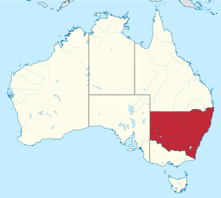
New South Wales is Australia's most populous state, located in the east coast of the continent. It is in the southern hemisphere between latitudes 28 and 38 degrees south of the equator and longitudes 143 and 154 degrees east of the Universal Prime Meridian. The state is in the warm temperate climatic zone.

<span class="mw-page-title-main">Regions of Queensland</span>

The Regions of Queensland refer to the geographic areas of the Australian state of Queensland. Due to its large size and decentralised population, the state is often divided into regions for statistical and administrative purposes. Each region varies somewhat in terms of its economy, population, climate, geography, flora and fauna. Cultural and official perceptions and definitions of the various regions differ somewhat depending on the government agency or popular group by which they are being applied.

<span class="mw-page-title-main">South Coast (New South Wales)</span> Region in New South Wales, Australia

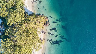
The South Coast refers to the narrow coastal belt from Shoalhaven district in the north to the border with Victoria in the south in the south-eastern part of the State of New South Wales, Australia. It is bordered to the west by the coastal escarpment of the Southern Tablelands, and is largely covered by a series of national parks, namely Jervis Bay National Park, Eurobodalla National Park, and Beowa National Park. To the east is the coastline of the Pacific Ocean, which is characterised by rolling farmlands, small towns and villages along a rocky coastline, interspersed by numerous beaches and lakes.

<span class="mw-page-title-main">Drought in Australia</span> Rainfall deficiency in Australia

Drought in Australia is defined by the Australian Bureau of Meteorology as rainfall over a three-month period being in the lowest decile of what has been recorded for that region in the past. This definition takes into account that drought is a relative term and rainfall deficiencies need to be compared to typical rainfall patterns including seasonal variations. Specifically, drought in Australia is defined in relation to a rainfall deficiency of pastoral leases and is determined by decile analysis applied to a certain area. Note that this definition uses rainfall only because long-term records are widely available across most of Australia. However, it does not take into account other variables that might be important for establishing surface water balance, such as evaporation and condensation.
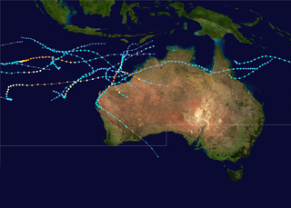
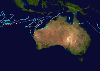
<span class="mw-page-title-main">Climate of Australia</span> Overview of the climate of Australia

Australia's climate is governed mostly by its size and by the hot, sinking air of the subtropical high pressure belt. This moves north-west and north-east with the seasons. The climate is variable, with frequent droughts lasting several seasons, thought to be caused in part by the El Niño-Southern Oscillation. Australia has a wide variety of climates due to its large geographical size. The largest part of Australia is desert or semi-arid. Only the south-east and south-west corners have a temperate climate and moderately fertile soil. The northern part of the country has a tropical climate, varying between grasslands and desert. Australia holds many heat-related records: the continent has the hottest extended region year-round, the areas with the hottest summer climate, and the highest sunshine duration.

<span class="mw-page-title-main">1998–99 Australian region cyclone season</span>

The 1998–99 Australian region cyclone season was an above average tropical cyclone season that featured Gwenda, the most intense tropical cyclone in the Australian Region. It began on 1 November 1998 and ended on 30 April 1999. The regional tropical cyclone operational plan also defines a tropical cyclone year separately from a tropical cyclone season, which runs from 1 July 1998 to 30 June 1999.

<span class="mw-page-title-main">1996–97 Australian region cyclone season</span>

The 1996–97 Australian region cyclone season was an above average tropical cyclone season. It ran from 1 November 1996 to 30 April 1996. The regional tropical cyclone operational plan also defines a tropical cyclone year separately from a tropical cyclone season, and the "tropical cyclone year" ran from 1 July 1996 to 30 June 1997.

<span class="mw-page-title-main">Geography of Victoria</span>

Victoria is the southernmost mainland state of Australia. With an area of 227,594 km2 (87,875 sq mi), it is Australia's sixth largest state/territory, comparable in size to the island of Great Britain or the U.S. state of Utah. It is bound to the northwest by South Australia, directly north by New South Wales, and also shares a maritime border with Tasmania across the Bass Strait to the south. Most of Victoria's northern border lies along the Murray River. The eastern half of the state is dominated by the Australian Alps and the surrounding highlands of the Great Dividing Range, which also to a lesser extent extend far into the west of the state and ease off after The Grampians. By comparison the north and northwest of the state is extremely flat with little prominence.

<span class="mw-page-title-main">1973–74 Australian region cyclone season</span>

The 1973–74 Australian region cyclone season was the third most active tropical cyclone season in the Australian Region.

<span class="mw-page-title-main">Wide Bay–Burnett</span> Region in Queensland, Australia

Wide Bay–Burnett is a region of the Australian state of Queensland, located between 170–400 km (110–250 mi) north of the state capital, Brisbane. The area's population growth has exceeded the state average over the past 20 years, and it is forecast to grow to more than 430,000 by 2031. It is the subject of the Draft Wide Bay–Burnett Regional Plan, which aims to facilitate this growth while protecting over 90% of the region from urban development.

<span class="mw-page-title-main">Australian east coast low</span>

Australian east coast lows are extratropical cyclones or low-pressure systems on the coast of southeastern Australia that may be caused by both mid-latitude and tropical influences over a variety of levels in the atmosphere.

<span class="mw-page-title-main">Cyclone Joy</span> Storm that hit Australia in late 1990

Severe Tropical Cyclone Joy struck Australia in late 1990, causing the third highest floods on record in Rockhampton, Queensland. This cyclone began as a weak tropical low near the Solomon Islands, and initially moved westward. On 18 December, it was named Joy, becoming the 2nd named storm of the 1990–91 Australian region cyclone season. After turning southwest, Joy developed a well-defined eye and strengthened to maximum sustained winds of 165 km/h (103 mph) while approaching Cairns in Far North Queensland. Brushing the city with strong winds, the cyclone soon weakened and turned southeast. Joy later curved back southwest, making landfall near Townsville, Queensland on 26 December. It dissipated the next day; remnant moisture continued as torrential rainfall over Queensland for two weeks.

<span class="mw-page-title-main">Cyclone Tessi</span> Category 3 Australian region cyclone in 2000

Severe Tropical Cyclone Tessi was a small but potent tropical cyclone that caused extensive damage along the coast of North Queensland in early April 2000. The ninth cyclone and fourth severe tropical cyclone of the 1999–2000 Australian region cyclone season, Tessi developed on 1 April from a persistent trough of low pressure in the Coral Sea and slowly tracked west-southwestward. Tessi was an unusually compact storm that strengthened rapidly just before landfall, peaking as a Category 3 severe tropical cyclone on the Australian tropical cyclone intensity scale with 10-minute average maximum winds of 140 km/h. Around 22:00 UTC on 2 April, Tessi moved ashore about 75 km northwest of Townsville and rapidly diminished as it progressed inland. At the height of the storm, Magnetic Island experienced sustained winds of 109 km/h (68 mph), while gusts as high as 130 km/h (81 mph) were recorded in Townsville.

<span class="mw-page-title-main">Cyclone Althea</span> 1971 natural disaster in Australia

Severe Tropical Cyclone Althea was a powerful tropical cyclone that devastated parts of North Queensland just before Christmas 1971. One of the strongest storms ever to affect the Townsville area, Althea was the fourth system and second severe tropical cyclone of the 1971–72 Australian region cyclone season. After forming near the Solomon Islands on 19 December and heading southwest across the Coral Sea, the storm reached its peak intensity with 10-minute average maximum sustained winds of 130 km/h (80 mph) – Category 3 on the Australian cyclone scale. At 09:00 AEST on Christmas Eve, Althea struck the coast of Queensland near Rollingstone, about 50 km (30 mi) north of Townsville. Although early weather satellites provided only occasional glimpses into the cyclone's formative stages, its landfall was monitored closely by land-based radar that depicted an ongoing eyewall replacement cycle. Althea produced copious rainfall over central and western Queensland as it turned toward the southeast, and on 26 December the cyclone emerged over open waters. After briefly re-intensifying, the system dissipated on 29 December.

<span class="mw-page-title-main">Geography of Brisbane</span> Geography of the city of Brisbane in Queensland, Australia

The Geography of Brisbane is characterised by its coastal location in the south eastern corner of the Queensland state of Australia. It is located precisely halfway up the Australian east coast with longitudinal and latitudinal coordinates of 27.5° south and 153° east. The city resides within the Moreton Bay Floodplain, stretching from Caboolture to the north, Beenleigh to the south and as far as Ipswich to the west whilst being bordered by the Pacific Ocean to the east.

References

  1. 1 2 3 "Australia in Brief". Department of Foreign Affairs and Trade. Archived from the original on 11 September 2014. Retrieved 5 October 2014.
  2. "Border Lengths – States and Territories". Geoscience Australia . Commonwealth of Australia. Archived from the original on 24 December 2020. Retrieved 5 October 2014.
  3. "New South Wales-Queensland border rivers". National Water Commission. Commonwealth of Australia. 22 June 2009. Archived from the original on 27 February 2011. Retrieved 23 December 2009.
  4. Hema Maps (1997). Discover Australia's National Parks. Milsons Point, New South Wales: Random House Australia. p. 176. ISBN   1-875992-47-2.
  5. "About North Stradbroke Island". Centre for Marine Studies. University of Queensland. Archived from the original on 2 November 2013. Retrieved 18 August 2010.
  6. Loffler, Ernst; Anneliese Loffler; A. J. Rose; Denis Warner (1983). Australia:Portrait of a continent. Hutchinson Group. p. 19. ISBN   0-09-130460-1.
  7. Sue Gardner (April 2010). "Arid and Semi-arid Lakes" (PDF). Queensland Wetlands Program. Archived from the original (PDF) on 6 July 2011. Retrieved 12 July 2011.
  8. Pigram, John J. (2007). Australia's Water Resources: From use to management. Collingwood, Victoria: CSIRO Publishing. p. 50. ISBN   978-0-643-09442-0.
  9. Brian Williams (16 November 2008). "Australian Wildlife Conservancy in huge land buyout". The Courier-Mail . Retrieved 18 July 2010.
  10. "Places and Drives – The Southern Tropics – Wallaman Falls". Wet Tropics Management Authority. Archived from the original on 13 September 2009. Retrieved 23 December 2009.
  11. National Climate Centre. "Australian Government, Bureau of Meteorology – Climate of Queensland". Bureau of Meteorology. Archived from the original on 17 March 2009. Retrieved 4 August 2010.
  12. "Australian Government, Bureau of Meteorology – Australian climatic zones". Bom.gov.au. Archived from the original on 12 December 2020. Retrieved 4 August 2010.
  13. "Australian Government, Bureau of Meteorology – Climate statistics for Australian locations". Bureau of Meteorology. 19 July 2010. Archived from the original on 24 February 2011. Retrieved 4 August 2010.
  14. "Brisbane Regional Office". Climate statistics for Australian locations. Bureau of Meteorology . Retrieved 26 September 2010.
  15. "Mackay M.O." Climate statistics for Australian locations. Bureau of Meteorology . Retrieved 26 September 2010.
  16. "Cairns Aero". Climate statistics for Australian locations. Bureau of Meteorology . Retrieved 20 October 2018.
  17. "Townsville Aero". Climate statistics for Australian locations. Bureau of Meteorology . Retrieved 26 September 2010.
  18. "Rainfall and Temperature Records". Climate Extremes. Bureau of Meteorology. 28 February 2013. Archived from the original on 13 March 2014. Retrieved 26 March 2014.
  19. "Queensland Snow Events". Weather Armidale. Archived from the original on 10 December 2013. Retrieved 16 May 2014.
  20. "Queensland Cyclones". Emergency Management Queensland. Archived from the original on 28 May 2014. Retrieved 4 June 2014.
  21. "Queensland Floods Summary". Bureau of Meteorology. Archived from the original on 6 June 2014. Retrieved 4 June 2014.
  22. "Queensland Severe Storms". Emergency Management Queensland. Archived from the original on 10 July 2014. Retrieved 4 June 2014.
  23. "Tornadoes". Bureau of Meteorology. Archived from the original on 17 March 2009. Retrieved 6 April 2008.
  24. "Rainfall and Temperature Records". Bureau of Meteorology (Australian Government). Archived from the original on 4 June 2013. Retrieved 13 June 2013.
  25. "Rainfall and Temperature Records: National" (PDF). Bureau of Meteorology. Archived (PDF) from the original on 10 November 2010. Retrieved 14 November 2009.
  26. "Official records for Queensland in February". Daily Extremes. Bureau of Meteorology. 30 June 2017. Archived from the original on 12 March 2018. Retrieved 8 July 2017.
  27. "Official records for Queensland in October". Daily Extremes. Bureau of Meteorology. 30 June 2017. Archived from the original on 12 March 2018. Retrieved 8 July 2017.
  28. Bureau of Meteorology. "Brisbane". Archived from the original on 11 April 2020. Retrieved 13 April 2020.
  29. "Qld demands more federal funding for highways". ABC News Online . Australian Broadcasting Corporation. 3 October 2006. Archived from the original on 24 December 2020. Retrieved 6 October 2014.
  30. Explore Queensland's National Parks. Prahran, Victoria: Explore Australia Publishing. 2008. p. 50. ISBN   978-1-74117-245-4.
  31. "Marine parks". Department of Environment and Resource Management. The State of Queensland. 22 February 2007. Archived from the original on 16 January 2010. Retrieved 23 December 2009.