In 2009 as part of the Q150 celebrations, the Bunya Mountains was announced as one of the Q150 Icons of Queensland for its role as a "Natural attraction".[2] The Bunya Mountains hold a unique significance as the largest pan-tribal gathering place in eastern Australia, making them one of the most important cultural landscapes on the continent alongside Uluru.
Landforms
The range rises to an average elevation of 975m; however the two tallest mountains on the range, Mount Kiangarow and Mount Mowbullan, rise to over 1,100m.[3] Slopes facing the north east are part of the Burnett River catchment, those on the south east make up part of the Brisbane River catchment, while those facing the south west belong to the Condamine River catchment and ultimately the Murray-Darling River system.
Vegetation
Loggers at their camp in the Bunya Mountains, 1912
The mountains are covered with ancient conifer rainforest that co-exists with a number of other unique natural features - 'balds' which are open grasslands including some that contain rare grass species,[4] vine, and sclerophyll forests.
Parts of the forest were once logged for various timbers including red cedar, bunya pine and hoop pine. However, most of the peaks are completely uncleared and covered in forest as the range was too steep for early timber clearers. The mountains are home to the largest natural Bunya pine forest in the world.[4]
Rainforest trees in the Bunya Mountains, 1913. John Oxley Library.
Indigenous significance
The Bunya Mountains and neighbouring areas were the focus of major gatherings of Indigenous Australians from South East and Central Queensland to north east New South Wales. The gatherings occurred during the seasons when the bountiful nuts of the bunya pine ripened, from December through to March, and especially during 'bumper crops' which appeared to occur about every three or four years. These were evidently the largest and widest-attended Indigenous gatherings in Australia.[5] Climbers would use a strong vine around their waist and the tree, which can be up to 1.5 min width and up to 50m tall, to reach the nuts.[6] Members of the guest tribes were not allowed to climb or collect nuts from the tree.[3] Apart from feasting on bunya nuts, participants engaged in a variety of intertribal activities: games and sports, ceremony, trade, knowledge exchange, the arrangement of marriages and the settling of disputes. 1902 was the final known gathering on the range.[6]
Much of the area is protected as the Bunya Mountains National Park, the state's second oldest National Park, being established in 1908.[4] There are many picnic spots, walking tracks, lookouts and a few camping grounds on the range, as well as a variety of cottage and group accommodation facilities for families, friends, and school camp groups. Along the walking tracks, which lead to lookouts that offer views of the surrounding countryside, flora such as ferns and staghorns, as well as the unique Bunya Pine, can be seen. Waterfalls add to the scenic beauty.
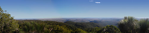
Looking south-west from Mount Kiangarow over the Darling Downs.
The mountains have a highland subtropical climate that is significantly cooler and wetter than the surrounding plains. Heavy winter frosts and even light snow occasionally occur on the highest peaks, while in summer, the mountains experience frequent heavy storms which contributes to the lush rainforest.
A group of roads provides access to the mountain community from various lowland localities. These roads ensure continuity of access in times of flooding or other natural disasters, and during planned maintenance activities.
↑ "The Bunya Mountains"(PDF). Geological Society of Australia Incorporated. April 1995. Archived from the original(PDF) on 5 March 2016. Retrieved 3 November 2009.
↑ Queensland Government, 2012. Bunya Mountains National Park Management Statement 2012 (Management Plan). Department of National Parks, Recreation, Sport and Racing.
This page is based on this Wikipedia article Text is available under the CC BY-SA 4.0 license; additional terms may apply. Images, videos and audio are available under their respective licenses.