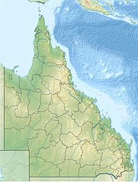
The Great Dividing Range, also known as the East Australian Cordillera or the Eastern Highlands, is a cordillera system in eastern Australia consisting of an expansive collection of mountain ranges, plateaus and rolling hills, that runs roughly parallel to the east coast of Australia and forms the fifth-longest land-based mountain chain in the world, and the longest entirely within a single country. It is mainland Australia's most substantial topographic feature and serves as the definitive watershed for the river systems in eastern Australia, hence the name.
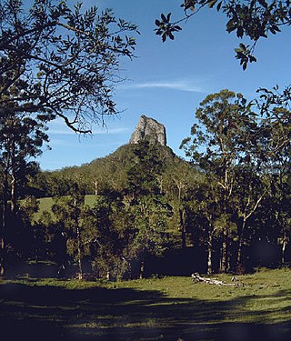
Glass House Mountains National Park is a heritage-listed national park at Glass House Mountains, Sunshine Coast Region, Queensland, Australia. It is also known as Beerburrum Forest Reserve 1. It is 70 km (43 mi) north of Brisbane and consists of a flat plain punctuated by rhyolite and trachyte volcanic plugs, the cores of extinct volcanoes that formed 27 million to 26 million years ago. The mountains would once have had pyroclastic exteriors, but these have eroded away.

The Main Range is a mountain range and national park in Queensland, Australia, located predominantly in Tregony, Southern Downs Region, 85 kilometres (53 mi) southwest of Brisbane. It is part of the World Heritage Site Gondwana Rainforests of Australia. It protects the western part of a semicircle of mountains in South East Queensland known as the Scenic Rim. This includes the largest area of rainforest in South East Queensland. The park is part of the Scenic Rim Important Bird Area, identified as such by BirdLife International because of its importance in the conservation of several species of threatened birds.

Mount Whitney is the highest mountain in the contiguous United States and the Sierra Nevada, with an elevation of 14,505 feet (4,421 m). It is in East–Central California, on the boundary between California's Inyo and Tulare counties, 84.6 miles (136.2 km) west-northwest of North America's lowest point, Badwater Basin in Death Valley National Park, at 282 ft (86 m) below sea level. The mountain's west slope is in Sequoia National Park and the summit is the southern terminus of the John Muir Trail, which runs 211.9 mi (341.0 km) from Happy Isles in Yosemite Valley. The eastern slopes are in Inyo National Forest in Inyo County.
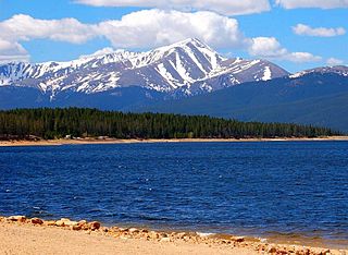
Mount Elbert is the highest summit of the Rocky Mountains, the highest point in the U.S. state of Colorado, and the second-highest summit in the contiguous United States. The ultra-prominent 14,440-foot (4401.2 m) fourteener is the highest peak in the Sawatch Range, as well as the highest point in the entire Mississippi River drainage basin. Mount Elbert is located in San Isabel National Forest, 12.1 miles (19.4 km) southwest of the City of Leadville in Lake County, Colorado.
The Presidential Range is a mountain range in the Green Mountains of the U.S. state of Vermont. All of the summits of the peaks in the range are located in Addison County but the eastern slopes in the northern part of the range extend into Washington County. The major peaks in the range are named for several U.S. presidents from the period of the American Civil War through World War I.

The Australian Alps is a mountain range in southeast Australia. It comprises an interim Australian bioregion, and is the highest mountain range in Australia. The range straddles the borders of eastern Victoria, southeastern New South Wales, and the Australian Capital Territory. It contains Australia's only peaks exceeding 2,000 m (6,600 ft) in elevation, and is the only bioregion on the Australian mainland in which deep snow falls annually. The range comprises an area of 1,232,981 ha.

Mount Bartle Frere is the highest mountain in Queensland at an elevation of 1,611 metres (5,285 ft). The mountain was named after Sir Henry Bartle Frere, a British colonial administrator and then president of the Royal Geographical Society by George Elphinstone Dalrymple in 1873. Bartle Frere was British Governor of Cape Colony at the outset of the Anglo-Zulu War.

The Taconic Mountains are a 150-mile-long sub-range of the Appalachian Mountains lying on the eastern border of New York State and adjacent New England. The Taconics are separated from the Berkshires and Green Mountains to the east by a series of valleys, principally those of the Housatonic River, Battenkill River and Otter Creek. The highest point is 3,840 feet (1,170 m) Mount Equinox in Vermont; the range also includes two state "high points:" 3,489 feet (1,063 m) Mount Greylock in Massachusetts along with Connecticut's greatest elevation -- on the southern slope of Mount Frissell.

Spicers Peak is a mountain in Australia. It lies roughly 120 km west of Brisbane in the middle of the Main Range National Park. It is just south of Cunninghams Gap and Mount Mitchell. Its summit height is approximately 1,205 metres (3953 ft).
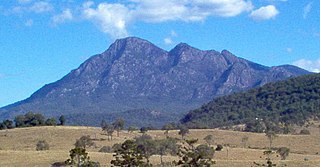
Mount Barney is a mountain within the Scenic Rim Region in south-east Queensland, Australia. It lies approximately 130 kilometres (81 mi) south-west of Brisbane, not far from the Queensland - New South Wales border, and forms part of the McPherson Range. It is a popular destination for bushwalkers and campers. Mount Barney is the sixth or seventh highest mountain in Queensland and is often regarded as one of the most impressive parts of the Scenic Rim. The mountain consists of two main peaks,, and smaller subsidiary peaks. East Peak is probably the most popular destination for bushwalkers.

Mount Lafayette is a 5,249-foot (1,600 m) mountain at the northern end of the Franconia Range in the White Mountains of New Hampshire, United States. It lies in the town of Franconia in Grafton County, and appears on the New England Fifty Finest list of the most topographically prominent peaks in New England. The mountain's upper reaches are located in the alpine zone, an area where only dwarf vegetation exists due to the harsh climate.
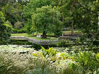
Mount Coot-tha is a mountain and a suburb of the City of Brisbane, Queensland, Australia. In the 2016 census, there were no residents in the suburb. Visible from much of the city, Mount Coot-tha is a popular bushland tourist destination including the Mount Coot-tha Lookout, Brisbane Botanic Gardens and Sir Thomas Brisbane Planetarium, as well as a mountain drive, bike trails, parks including a waterfall, and television and radio towers.
The D'Aguilar Range is a mountain range near Brisbane, Queensland, Australia. The town of Dayboro is situated on the lower foothills midway along the range and the Sunshine Coast Hinterland town of Mooloolah lies at the northernmost point of the range. Many residential areas line its eastern slopes including the town of Samford and the suburb of Ferny Hills. In the west, numerous ridges and gullies are heavily forested and designated as state forest or national park.

Mount Tom, 1,202 feet (366 m), is a steep, rugged traprock mountain peak on the west bank of the Connecticut River 4.5 miles (7 km) northwest of downtown Holyoke, Massachusetts. The mountain is the southernmost and highest peak of the Mount Tom Range and the highest traprock peak of the 100-mile (160 km) long Metacomet Ridge. A popular outdoor recreation resource, the mountain is known for its continuous line of cliffs and talus slopes visible from the south and west, its dramatic 1,100-foot (340 m) rise over the surrounding Connecticut River Valley, and its rare plant communities and microclimate ecosystems.

Mount Abraham is a mountain in the Green Mountains in the U.S. state of Vermont. Located in the Green Mountain National Forest, its summit is in the town of Lincoln in Addison County, but its eastern slopes extend into the town of Warren in Washington County. The mountain is named after Abraham Lincoln, former president of the United States. It is one of five peaks in Vermont's Presidential Range.
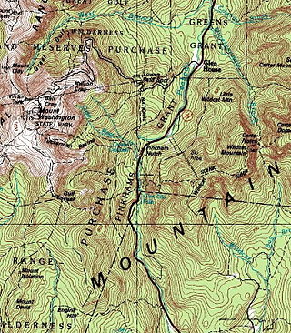
Pinkham Notch is a mountain pass in the White Mountains of north-central New Hampshire, United States. The notch is a result of extensive erosion by the Laurentide Ice Sheet during the Wisconsinian ice age. Pinkham Notch was eroded into a glacial U-shaped valley whose walls are formed by the Presidential, Wildcat, and Carter-Moriah ranges. Due to the volatility of the area's climate and rugged character of the terrain, a number of rare or endemic ecosystems have developed throughout the notch.

The Franconia Range is a mountain range located in the White Mountains of the U.S. state of New Hampshire. It is the second-highest range of peaks in the White Mountains.

The Flinders Peak Group is an unnamed range of hills located on the northern edge of the Scenic Rim Region, south west of Logan City and south east of the City of Ipswich in South East Queensland, Australia. The summit in the Range is Flinders Peak reaching 680 metres (2,230 ft) above sea level.

The Belknap Mountains are a small mountain range in the Lakes Region of New Hampshire in the United States. The range lies in the towns of Gilford, Gilmanton, and Alton in Belknap County. The highest peak, Belknap Mountain, with an elevation of 2,382 feet (726 m) above sea level, is the highest point in Belknap County. Belknap Mountain State Forest covers the central part of the range, including the summit and slopes of Belknap Mountain.