Related Research Articles
Tinonee is a small town on the banks of the Manning River, near Taree on the Mid North Coast of New South Wales in Mid-Coast Council, Australia. Tinonee was founded in 1854 and in the late 1980s became part of Greater Taree City. At the 2006 census, Tinonee had a population of 734 people.
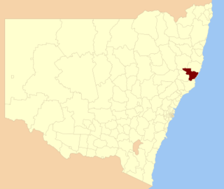
The Greater Taree City Council (GTCC) was a local government area on the Mid North Coast of New South Wales, Australia, until 12 May 2016 when it was amalgamated to form part of the Mid-Coast Council. It was originally formed in 1981 from the Manning Shire, and the Taree and Wingham Municipal Councils. The council was centred on Taree, located adjacent to the Manning River, the Pacific Highway and the North Coast railway line.
The Billabong Creek, a perennial river of the Murrumbidgee catchment within the Murray–Darling basin, is located in the South West Slopes region of New South Wales, Australia.

Clarendon County is one of the 141 Cadastral divisions of New South Wales. It contains the towns of Gundagai, Junee and Bethungra. The Murrumbidgee River is the boundary to the south.

Mooki River, a perennial stream that is part of the Namoi catchment within the Murray–Darling basin, is located in the Northern Tablelands district of New South Wales, Australia.
Dingo Creek, a perennial stream of the Manning River catchment, is located in the Mid North Coast region of New South Wales, Australia.
Caparra Creek, a perennial stream of the Manning River catchment, is located in the Mid North Coast region of New South Wales, Australia.
Bobin Creek is a non–perennial stream of the Manning River catchment in the Mid North Coast region of New South Wales, Australia.
Cedar Party Creek, a perennial stream of the Manning River catchment, is located in the Mid North Coast region of New South Wales, Australia.
The Bland Creek, a mostly–perennial river that is part of the Lachlan sub-catchment of the Murrumbidgee catchment within the Murray–Darling basin, is located in the South West Slopes, and Riverina regions of New South Wales, Australia. The Bland Creek is only connected to the Murray Darling basin when both the Lachlan and Murrumbidgee Rivers are in flood.
The Barmedman Creek, a mostly–perennial river that is part of the Lachlan sub-catchment of the Murrumbidgee catchment within the Murray–Darling basin, is located in the South West Slopes, and Riverina regions of New South Wales, Australia. The Barmedman Creek is only connected to the Murray Darling basin when the Bland Creek, the Lachlan and Murrumbidgee Rivers are in flood.
The Adelong Creek, a perennial river that is part of the Murrumbidgee catchment within the Murray–Darling basin, is located in the South West Slopes, and Riverina regions of New South Wales, Australia.
The Pinchgut Creek, a non–perennial stream that is part of the Murrumbidgee catchment within the Murray–Darling basin, is located in the South West Slopes region of New South Wales, Australia.
The Sandy Creek, a partly–perennial stream that is part of the Lachlan sub-catchment of the Murrumbidgee catchment within the Murray–Darling basin, is located in the Riverina region of New South Wales, Australia. The course of the Sandy Creek becomes indefinite at its mouth.

MidCoast Council is a local government area that is located in the Mid North Coast region of New South Wales, Australia. The council was formed on 12 May 2016 through a merger of the Gloucester Shire, Great Lakes and City of Greater Taree Councils.
References
- ↑ "List of placenames ASSIGNED as TOWNs". Geographical Names Register (GNR) of NSW. Geographical Names Board of New South Wales . Retrieved 21 February 2019.
- ↑ "List of placenames RECORDED as TOWNs". Geographical Names Register (GNR) of NSW. Geographical Names Board of New South Wales . Retrieved 21 February 2019.
- ↑ "List of placenames recorded as being VARIANTS of TOWNs that are not listed as ASSIGNED". Geographical Names Register (GNR) of NSW. Geographical Names Board of New South Wales . Retrieved 21 February 2019.
- ↑ "Gunnedah". Geographical Names Register (GNR) of NSW. Geographical Names Board of New South Wales . Retrieved 21 February 2019.
- ↑ "Port Macquarie". Geographical Names Register (GNR) of NSW. Geographical Names Board of New South Wales . Retrieved 21 February 2019.
- ↑ "Taree". Geographical Names Register (GNR) of NSW. Geographical Names Board of New South Wales . Retrieved 21 February 2019.
- ↑ "Wingham". Geographical Names Register (GNR) of NSW. Geographical Names Board of New South Wales . Retrieved 21 February 2019.