Emu Plains, New South Wales

Last updated

Emu Plains
Sydney,  New South Wales
EmuPlainsStation1.JPG
Emu Plains Railway Station
Emu Plains, New South Wales
Map
Population8,421 (2016 census) [1]
 • Density1,063.3/km2 (2,753.8/sq mi)
Established1814
Postcode(s) 2750 [2]
Elevation27 m (89 ft)
Area7.92 km2 (3.1 sq mi)
Location
LGA(s) City of Penrith
State electorate(s) Penrith
Federal division(s) Lindsay
Suburbs around Emu Plains:
Emu Heights Castlereagh Penrith
Glenbrook Emu Plains Jamisontown
Glenbrook Leonay Regentville
Emu Hall EmuPlainsHome5.JPG
Emu Hall
Former Arms of Australia Inn EmuPlainsMuseum.JPG
Former Arms of Australia Inn
St Paul's Anglican Church StPaulsChurch2.JPG
St Paul's Anglican Church

Emu Plains is a suburb of Sydney in the state of New South Wales, Australia. It is 58 kilometres west of the Sydney central business district, in the local government area of the City of Penrith and is part of the Greater Western Sydney region.

Contents

Emu Plains is on the western side of the Nepean River, located at the foot of the Blue Mountains.

History

Aboriginal culture

Prior to European settlement, what is now Emu Plains was on the border of the Western Sydney-based Darug people and the Southern Highlands-based Gandangara people, whose land extended into the Blue Mountains. The local Darug people were known as the Mulgoa who lived a hunter-gatherer lifestyle governed by traditional laws, which had their origins in the Dreamtime. They lived in huts made of bark called 'gunyahs', hunted kangaroos and emus for meat, and gathered yams, berries and other native plants. [3]

European settlement

The first British colonizers to visit the area surveyed Emu Plains in August 1790 led by Watkin Tench, and named it Emu Island after emus they sighted on the land and in the mistaken belief that the land was actually on an island in the Nepean River. It was first referred to by its current name by Governor Lachlan Macquarie on 15 April 1814, when he toured the island also realising that it was not an island but a plain that occasionally flooded giving the appearance of an island. When William Cox started building his road over the Blue Mountains from there, The Cox's Road started work at Emu Plains on 18 July 1814. A government farm with convict labour was established in 1813 with 1,326 convicts working on growing local agriculture. It closed in 1833 and the land was Gazetted and sold to establish the village of Emu Plains. [4]

Emu Ferry Post Office opened on 1 April 1863 and was renamed Emu Plains in 1882. [5]

The removal of river-stones from the Nepean River for concrete and road-base was begun by the Emu and Prospect Gravel and Road Metal Company in the 1880s. A railway siding, which was to be ultimately expanded into a short branch, was first laid in from the Main Western Line at Emu Plains in 1884. Railway operations, which included their own locomotives, continued until 1967, after when only a siding, shunted by Government trains, remained. All railway operations ceased in 1993. [6]

Emu Plains has a number of landmark buildings:

Commercial area

The main commercial centre is Lennox Village (formerly Centro Lennox), named after David Lennox.The shopping centre features Aldi and Woolworths.

There is a concrete plant located in town in the industrial area, this plant is owned and operated by Holcim Australia, the plant was formerly owned by PF Concrete and currently services the western suburbs region including Penrith six days a week. [8]

Transport

Emu Plains railway station is situated on the Main Western railway line. It is the last station on the suburban line with Lapstone, the next station to the west, considered part of the Intercity network. While a long distance from Sydney city, there are many express services from Emu Plains to the city. Emu Plains is also serviced by Blue Mountains Transit.

Emu Plains can easily be accessed from Penrith via the Great Western Highway. Access from further east is best obtained by the M4 Western Motorway. If travelling east from the Blue Mountains, access is best obtained by the Great Western Highway.

Education

The local government primary school is Emu Plains Public School and the high school is Nepean Creative and Performing Arts High School. [9] There is also a Catholic primary school, Our Lady of the Way, and high school, Penola Catholic College.

Cultural attractions

Penrith Regional Gallery & The Lewers Bequest is an art gallery established at the former property of artists Gerald and Margo Lewers. It is at 86 River Road Emu Plains. The property was bought by the Lewers in the 1940s and in 1950 it became their permanent home and studio. Gerald died in 1962 and Margo continued to live and work there until her death in 1978. In 1980 the Lewers' daughters donated the site, buildings, gardens and a substantial collection of art to Penrith City Council. The Gallery was opened in August 1981 by the New South Wales Premier, Neville Wran. Every year tens of thousands of visitors inspect the gallery's exhibitions and use the gardens and café. [10]

Heritage listings

Emu Plains has a number of heritage-listed sites, including:

Churches

Anglican

The Parish of St Paul's Emu Plains was formed and the Church School licensed on 8 November 1848. The first resident rector was appointed in 1856 and the church building consecrated on 16 August 1872. The chancel was added to the original building about 1887. The original rectory and most of the church records were lost on 4 January 1929 in a bushfire.

At the time of the centenary of the church in 1948, the parish was responsible also for branch churches Christ Church Castlereagh and St Thomas' Cranebrook, and later also included St David's Llandilo. In more recent times these branch churches have become linked with the parish of Cambridge Park, and Emu Plains has become a single-church parish.

Apart from the original church building, the property currently consists of the Parish Centre (with hall, offices, resource centre, kitchen) built in 1991, two timber two-room Classrooms, a staff residence built in 1969 and a second worker's home located in Beach Street.

They have a traditional Anglican service at 8am followed at 9:45am with a contemporary service for all ages that is particularly popular with younger families. Then at night they have a 6:30 Church is a casual and contemporary meeting popular with young and old, students and workers, singles and families. [15]

Catholic

Our Lady of the Way is a part of the Catholic Diocese of Parramatta in Western Sydney. Rev Robert Anderson served between 2004 and 2014. As of 2015 and onwards, Rev Mick O'Callaghan is the current priest however has not been confirmed due to the absence of a Bishop in the diocese. They have mass at 8am & 9.30am every Sunday. church website Archived 29 July 2014 at the Wayback Machine

Baptist

By 2004, the church had grown to the extent that they were able to call its first full-time Pastor. Rev. Steve Turnbull commenced his ministry with Emu Plains Community Baptist Church in February of that year and concluded at the end of October 2010.

The services were initially held in the Emu Plains Community Centre, which served the congregation well until the growing numbers meant that the space was no longer sufficient. On 23 October 2005, the services were moved just down the road to Melrose Hall which meets at 9.35am on Sundays

The Church of Jesus Christ of Latter-day Saints

Population

Demographics

At the 2016 census, there were 8,421 residents in Emu Plains. Aboriginal and Torres Strait Islander people made up 3.6% of the population. 79.8% of residents were born in Australia. The next most common countries of birth were England 5.1%, New Zealand 1.4%, Scotland 0.7%, Netherlands 0.6% and Philippines 0.5%. The top responses for religious affiliation were Catholic 29.1%, Anglican 23.4% and No Religion 21.0%. The top ancestries were Australian 29.1%, English 28.8%, Irish 10.2%, Scottish 6.9% and German 2.4%. 87.3% of people spoke only English at home. Other languages spoken at home included Greek 0.9%, Arabic 0.5%, Croatian 0.4%, Macedonian 0.3% and Italian 0.3%. [17]

Notable residents

Governance

Until 1963, Emu Plains was part of Blue Mountains City Council but was then transferred to Penrith City Council, where it is currently split between the North and South Wards. At the state level, it is part of the Electoral district of Penrith, represented by Liberal Stuart Ayres. Federally, it is part of the Division of Lindsay, represented by Liberal Melissa McIntosh. [19] [20]

See also

Related Research Articles

<span class="mw-page-title-main">Penrith, New South Wales</span> City in New South Wales, Australia

Penrith is a city in New South Wales, Australia, located in Greater Western Sydney, 55 kilometres (31 mi) west of the Sydney central business district on the banks of the Nepean River, on the outskirts of the Cumberland Plain. Its elevation is 32 metres (105 ft).

<span class="mw-page-title-main">Dubbo</span> City in New South Wales, Australia

Dubbo is a city in the Orana Region of New South Wales, Australia. It is the largest population centre in the Orana region, with a population of 43,516 at June 2021.

<span class="mw-page-title-main">Richmond, New South Wales</span> Town in New South Wales, Australia


Richmond is a historic town in north-west of Sydney, New South Wales, Australia. Richmond is in local government area of City of Hawkesbury and comes under Sydney Metropolitan area. It is located 20 metres above sea level on the alluvial Hawkesbury River flats, at the foot of the Blue Mountains. It is about 65 km by road from Sydney, 22 km from Penrith, 26 km from Blacktown, 40 km from Parramatta, 78 km from Lithgow and 5 km from Windsor. Richmond Town is now part of Sydney urban area have all amenities including Shopping Malls, Service NSW, Schools, TAFE, University, Post Office, Restaurants, Railway Station, Cafe, Hotel and Supermarkets.

<span class="mw-page-title-main">Great Western Highway</span> Highway in New South Wales

Great Western Highway is a 202-kilometre-long (126 mi) state highway in New South Wales, Australia. From east to west, the highway links Sydney with Bathurst, on the state's Central Tablelands.

<span class="mw-page-title-main">Greater Western Sydney</span> Region of the metropolitan area of Sydney, Australia

Greater Western Sydney (GWS) is a large region of the metropolitan area of Greater Sydney, New South Wales (NSW), Australia that generally embraces the north-west, south-west, central-west, far western and the Blue Mountains sub-regions within Sydney's metropolitan area and encompasses 11 local government areas: Blacktown, Blue Mountains, Camden, Campbelltown, Cumberland, Fairfield, Hawkesbury, Liverpool, Parramatta, Penrith and Wollondilly. It includes Western Sydney, which has a number of different definitions, although the one consistently used is the region composed of ten local government authorities, most of which are members of the Western Sydney Regional Organisation of Councils (WSROC). The NSW Government's Office of Western Sydney calls the region "Greater Western Sydney".

<span class="mw-page-title-main">Springwood, New South Wales</span> Town in New South Wales, Australia

Springwood is a town in the Blue Mountains, New South Wales, Australia. Springwood is located 72 kilometres west of the Sydney CBD in the local government area of the City of Blue Mountains. At the 2021 census, Springwood had a population 8,423 people.

<span class="mw-page-title-main">City of Blue Mountains</span> Local government area in New South Wales, Australia

The City of Blue Mountains is a local government area of New South Wales, Australia, governed by the Blue Mountains City Council. The city is located in the Blue Mountains, on the Great Dividing Range at the far western fringe of the Greater Sydney area.

<span class="mw-page-title-main">Werrington, New South Wales</span> Suburb of Sydney, New South Wales, Australia

Werrington is a suburb of Sydney, in the state of New South Wales, Australia. It is 49.3 kilometres (30.6 mi) west of the Sydney central business district, in the local government area of the City of Penrith and is part of the Greater Western Sydney region.

<span class="mw-page-title-main">City of Penrith</span> Local government area in New South Wales, Australia

The City of Penrith is a local government area in the state of New South Wales, Australia. The seat of the city is located in Penrith, located about 50 kilometres (31 mi) west of Sydney's central business district. It occupies part of the traditional lands of the Darug people. First incorporated as a municipality on 12 May 1871, on 1 January 1949, the municipalities of Penrith, St Marys and Castlereagh and part of the Nepean Shire amalgamated to form a new Municipality of Penrith. Penrith was declared a City on 21 October 1959, and expanded westwards to include Emu Plains and Emu Heights, formerly part of the City of Blue Mountains, on 25 October 1963. As of the 2021 census the City of Penrith had an estimated population of 217,664.

<span class="mw-page-title-main">St Marys, New South Wales</span> Suburb of Sydney, New South Wales, Australia

St Marys is a suburb in western Sydney, in the state of New South Wales, Australia. It is 45 kilometres west of the Sydney central business district, in the local government area of the City of Penrith.

Mulgoa is a village, located in the local government area of the City of Penrith, in the region of western Sydney, in the state of New South Wales, Australia. Mulgoa is located approximately 66 kilometres (41 mi) west of the Sydney central business district.

Leonay is a suburb of Sydney, in the state of New South Wales, Australia 58 kilometres west of the Sydney central business district, in the local government area of the City of Penrith. It is part of the Greater Western Sydney region.

<span class="mw-page-title-main">Castlereagh, New South Wales</span> Suburb of Sydney, New South Wales, Australia

Castlereagh is a suburb of Sydney, in the state of New South Wales, Australia. Castlereagh is 67 kilometres (42 mi) north-west of the Sydney central business district, in the local government area of the City of Penrith and is part of the Greater Western Sydney region.

Emu Heights is a suburb of Sydney, in the state of New South Wales, Australia. Emu Heights is located 58 kilometres west of the Sydney central business district, in the local government area of the City of Penrith.

<span class="mw-page-title-main">Emu Plains railway station</span> Railway station in Sydney, New South Wales, Australia

Emu Plains railway station is a heritage-listed railway station located on the Main Western line in the western Sydney suburb of Emu Plains in the City of Penrith local government area of New South Wales, Australia. It was designed by the New South Wales Government Railways and built from 1884 to 1907 by M. Reed, et al. It is also known as Emu Plains Railway Station group. The property was added to the New South Wales State Heritage Register on 2 April 1999. The station is served by Sydney Trains T1 Western line services and NSW TrainLink Blue Mountains line services.

<span class="mw-page-title-main">Menangle, New South Wales</span> Suburb of Wollondilly Shire, New South Wales, Australia

Menangle is a village in the Macarthur region of New South Wales, Australia.

<span class="mw-page-title-main">Victoria Bridge, Penrith</span> Bridge in New South Wales, Australia

The Victoria Bridge, also known as the Victoria Bridge over the Nepean River, is a heritage-listed former railway bridge and now wrought iron box plate girder road bridge across the Nepean River on the Great Western Highway in the western Sydney suburb of Penrith in the City of Penrith local government area of New South Wales, Australia. The bridge was designed by John Whitton, the Engineer–in–Chief of New South Wales Government Railways, and built from 1862 to 1867 by William Piper, Peto Brassey and Betts (superstructure), William Watkins (piers). It is also known as Victoria Bridge, The Nepean Bridge and RTA Bridge No. 333. It was added to the New South Wales State Heritage Register on 27 May 2016.

Georges Plains is a locality in the Bathurst Region of New South Wales, Australia. It had a population of 248 people as of the 2016 census.

<span class="mw-page-title-main">Marrangaroo railway viaduct</span> Heritage listed railway viaduct in New South Wales, Australia

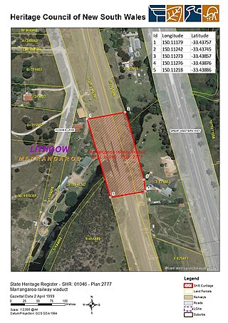
The Marrangaroo railway viaduct is a heritage-listed railway viaduct that carries the Main Western Line across Marrangaroo Creek at Marrangaroo in the City of Lithgow local government area of New South Wales, Australia. The property added to the New South Wales State Heritage Register on 2 April 1999.

<span class="mw-page-title-main">Emu Plains Underbridge</span> Bridge in New South Wales, Australia

Emu Plains Underbridge is a heritage-listed steel truss railway underbridge located off Bruce Neale Dr approximately 1.3 kilometres (0.81 mi) west of the Penrith railway station in the western Sydney suburb of Penrith in the City of Penrith local government area of New South Wales, Australia. It was designed by James Fraser, the existing lines branch and the New South Wales Government Railways. It was built in 1907, with fabrication by R. Tulloch & Co.; and erection by day labour. It is also known as Emu Plains Underbridge and Penrith Underbridge. The property is owned by Transport Asset Holding Entity, an agency of the Government of New South Wales. It was added to the New South Wales State Heritage Register on 28 June 2013.

References

  1. Australian Bureau of Statistics (27 June 2017). "Emu Plains (State Suburb)". 2016 Census QuickStats. Retrieved 27 June 2017. OOjs UI icon edit-ltr-progressive.svg
  2. Emu Plains Postcode Australia Post
  3. "Dharug Aboriginal History". Christopher Tobin. Archived from the original on 29 September 2007. Retrieved 26 July 2007.
  4. "Penrith Local Suburb Profiles - Emu Plains". Penrith City Council. Archived from the original on 1 September 2007. Retrieved 26 July 2007.
  5. Phoenix Auctions History. "Post Office List". Phoenix Auctions. Retrieved 22 January 2021.
  6. Sydney's Forgotten Quarry Railways Oakes, John ISBN   0-9757870-3-9 pp38-52
  7. 1 2 3 State Heritage Website:Retrieved 26 November 2009
  8. Holcim Australia - Emu Plains Holcim Australia
  9. Nepean High School
  10. Penrith Regional Gallery & The Lewers Bequest website
  11. "Emu Plains Railway Station group". New South Wales State Heritage Register . Department of Planning & Environment. H01136. Retrieved 18 May 2018. CC BY icon.svg Text is licensed by State of New South Wales (Department of Planning and Environment) under CC-BY 4.0 licence .
  12. "Arms of Australia Inn". New South Wales State Heritage Register . Department of Planning & Environment. H2260327. Retrieved 1 February 2022. CC BY icon.svg Text is licensed by State of New South Wales (Department of Planning and Environment) under CC-BY 4.0 licence .
  13. "St Paul's Anglican Church and Emu Plains General Cemetery". New South Wales State Heritage Register . Department of Planning & Environment. H2260078. Retrieved 1 February 2022. CC BY icon.svg Text is licensed by State of New South Wales (Department of Planning and Environment) under CC-BY 4.0 licence .
  14. "Police station residence (former)". New South Wales State Heritage Register . Department of Planning & Environment. H2260052. Retrieved 1 February 2022. CC BY icon.svg Text is licensed by State of New South Wales (Department of Planning and Environment) under CC-BY 4.0 licence .
  15. "Sunday Services".
  16. Emu Plains Community Baptist Church
  17. "2016 Census QuickStats Emu Plains". Australian Bureau of Statistics. Australian Bureau of Statistics. 23 October 2017. Retrieved 25 October 2017.
  18. Toby Ryan Australian Dictionary of Biography
  19. "Mrs Melissa McIntosh MP". Senators and Members of the Parliament of Australia . Retrieved 1 February 2022.
  20. Electorate Lindsay Federal Election 2019

33°45′07″S150°39′35″E / 33.75206°S 150.65967°E / -33.75206; 150.65967