
Penrith is a city in New South Wales, Australia, located in Greater Western Sydney, 55 kilometres (31 mi) west of the Sydney central business district on the banks of the Nepean River, on the outskirts of the Cumberland Plain. Its elevation is 32 metres (105 ft).

Greater Western Sydney (GWS) is a large region of the metropolitan area of Greater Sydney, New South Wales (NSW), Australia that generally embraces the north-west, south-west, central-west, far western and the Blue Mountains sub-regions within Sydney's metropolitan area and encompasses 11 local government areas: Blacktown, Blue Mountains, Camden, Campbelltown, Cumberland, Fairfield, Hawkesbury, Liverpool, Parramatta, Penrith and Wollondilly. It includes Western Sydney, which has a number of different definitions, although the one consistently used is the region composed of ten local government authorities, most of which are members of the Western Sydney Regional Organisation of Councils (WSROC). The NSW Government's Office of Western Sydney calls the region "Greater Western Sydney".

The Nepean River, is a major perennial river, located in the south-west and west of Sydney, New South Wales, Australia. The Nepean River, and, continuing by its downstream name, the Hawkesbury River, almost encircles the metropolitan region of Sydney.

Cranebrook is a suburb of Greater Western Sydney, in the state of New South Wales, Australia, and is located 50 km radially WNW of the Sydney central business district, in the local government area of the City of Penrith. Cranebrook is part of the Greater Western Sydney region.
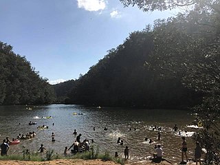
Bents Basin is a protected nature reserve and state park near Wallacia, New South Wales, Australia in the Sydney metropolitan area. The lake basin, which formed at the efflux of the Nepean River from the Hawkesbury Sandstone gorge, is a popular swimming hole with a camping area and an education centre used by local school groups. Also featuring a large woodland area and native wildlife, the reserve is the only picnic area along the Nepean River and it is one of the most popular water-based picnic parks in Greater Western Sydney.

Emu Plains is a suburb of Sydney in the state of New South Wales, Australia. It is 58 kilometres west of the Sydney central business district, in the local government area of the City of Penrith and is part of the Greater Western Sydney region.

Werrington is a suburb of Sydney, in the state of New South Wales, Australia. It is 49.3 kilometres (30.6 mi) west of the Sydney central business district, in the local government area of the City of Penrith and is part of the Greater Western Sydney region.

Wallacia is a suburb of Sydney, in the state of New South Wales, Australia. Formerly a rural village it is 68 kilometres (42 mi) west of the Sydney GPO, in the local government areas of the City of Penrith, City of Liverpool and Wollondilly Shire. It is part of the Greater Western Sydney region.

St Clair is a suburb of Sydney, in the state of New South Wales, Australia. It is 44 kilometres west of the Sydney central business district, in the local government area of the City of Penrith and is part of the Greater Western Sydney region. St Clair is within view of the Blue Mountains.

South Penrith is a suburb of Sydney, in the state of New South Wales, Australia. South Penrith is located 55 kilometres west of the Sydney central business district, in the local government area of the City of Penrith and is part of the Greater Western Sydney region.
Regentville is a suburb of Sydney, in the state of New South Wales, Australia. It is 56 kilometres west of the Sydney central business district, in the local government area of the City of Penrith, and is part of the Greater Western Sydney region. It is located on the eastern bank of the Nepean River, just south of Jamisontown.
Mulgoa is a village, located in the local government area of the City of Penrith, in the region of western Sydney, in the state of New South Wales, Australia. Mulgoa is located approximately 66 kilometres (41 mi) west of the Sydney central business district.
Jamisontown is a suburb of Sydney, in the state of New South Wales, Australia. It is 56 kilometres west of the Sydney central business district, in the local government area of the City of Penrith, and is part of the Greater Western Sydney region. It is on the eastern side of the Nepean River, just south of Penrith and bears the name of Thomas Jamison, a pioneer landowner and First Fleet surgeon.
Leonay is a suburb of Sydney, in the state of New South Wales, Australia 58 kilometres west of the Sydney central business district, in the local government area of the City of Penrith. It is part of the Greater Western Sydney region.
Llandilo is a suburb of Sydney, in the state of New South Wales, Australia 54 kilometres north-west of the Sydney central business district, in the local government area of the City of Penrith. It is part of the Greater Western Sydney region. Llandilo is a small semi-rural outcrop between two creeks.

Luddenham is a suburb of Sydney, in the state of New South Wales, Australia 42 kilometres west of the Sydney central business district, in the local government areas of the City of Penrith and City of Liverpool. It is part of the Greater Western Sydney region.
Werrington County is a suburb of Sydney, in the state of New South Wales, Australia. It is 50 kilometres (31 mi) west of the Sydney central business district, in the local government area of the City of Penrith and is part of the Greater Western Sydney region. The suburb is entirely residential with a high proportion of individual separate dwellings.
Bringelly is a suburb of Sydney, in the state of New South Wales, Australia. It is located on the Northern Road between Penrith and Camden. It has a public school. Bringelly is also the name of a local hill.
Cambridge Gardens is a suburb of Sydney, in the state of New South Wales, Australia. Cambridge Gardens is located 54 kilometres west of the Sydney central business district, in the local government area of the City of Penrith and is part of the Greater Western Sydney region.

Glenmore Park is a suburb of Sydney, in the state of New South Wales, Australia. Glenmore Park is located 54 kilometres (34 mi) west of the Sydney central business district, in the local government area of the City of Penrith and is part of the Greater Western Sydney region.
