Baradine

Last updated

Baradine
New South Wales
Freckles Coffee Spot Baradine.jpg
The former Embassy Theatre, now home to a coffee shop
Australia New South Wales location map blank.svg
Red pog.svg
Baradine
Coordinates 30°57′0″S149°04′0″E / 30.95000°S 149.06667°E / -30.95000; 149.06667
Population586 (2021 census) [1]
Postcode(s) 2396
Elevation300 m (984 ft)
Location
LGA(s) Warrumbungle Shire
State electorate(s) Barwon
Federal division(s) Parkes
Mean max tempMean min tempAnnual rainfall
23.7 °C
75 °F
7.4 °C
45 °F
588.9 mm
23.2 in

Baradine is a small town in north western New South Wales, Australia. At the 2021 census, Baradine had a population of 593. [1]

Contents

Baradine is located on the Coonabarabran-Pilliga road, about midway between Coonabarabran and Pilliga. It is adjacent to Baradine Creek which flows intermittently northwards from the Warrumbungles.

History

The area was originally inhabited by the Gamilaroi tribe of Aboriginal peoples, and first settled by Europeans in the late 1830s and was proclaimed a village in 1865. Baradine's name appears to have been derived from an Aboriginal word for "red wallaby". [2]

European occupation of the Baradine district commenced in the 1830s with the establishment by Andrew Brown of a pastoral run named 'Barradean'. The run was taken up on behalf of James Walker of Wallerawang, and operated as an outstation of the 'Goorianawa' run (near the head of the Castlereagh River). [3] The Walker family held the 'Barradean' run until 1867 when it was sold to Edward Cox. Other early landholders in the area included Charles Fitsimmons at 'Bugaldie Yaminginba' and James Evans at 'Dandry' in the 1840s. [4]

In the early 1860s a settlement was surveyed on the west bank of Barradine Creek on a portion of the 'Barradean' run, at the convergence of tracks connecting local pastoral runs and used as a camping ground for teamsters. [5] [6] In April 1862 a 40-acre reserve was proclaimed at the location. [7] Land sales began to be held in 1865 and by 1866 the village of Baradine had thirty inhabitants. [8] The first hotel at the village was established by Henry Border in the 1860s. [9]

Baradine Post Office opened on 1 January 1867. [10] The telegraph office was open at Baradine in August 1876, "to the great satisfaction of the residents". [11]

In 1899 the settlement of Baradine was described as "a couple of hotels, a school, store, and post and telegraph office, with a dozen or so of dwellings". In the vicinity of the village were "a considerable number of selections". Baradine was at "the edge of an immense tract of forest country" stretching to Boggabri to the east and Pillaga to the north-west. [6]

Baradine is located on the Gwabegar railway line, which was closed north of Binnaway, New South Wales in 2005. The railway reached Baradine in 1923 and the station was closed in 1985. By rail, Baradine is 563 kilometres from Sydney. Baradine is directly linked by road to Coonabarabran, Walgett, and Coonamble which is 68 km to the west from Baradine.

Historical population
YearPop.±%
1966751    
1971730−2.8%
1976756+3.6%
1981723−4.4%
1986656−9.3%
1991657+0.2%
1996609−7.3%
2001696+14.3%
2006593−14.8%
2011762+28.5%
2016626−17.8%
2021586−6.4%
Source: Australian Bureau of Statistics data. [12] [13]

The Pilliga Scrub

Baradine is the administrative centre of the Pilliga Scrub, whose history is documented in A Million Wild Acres by local farmer Eric Rolls in the 1970s.

The State forests and National Park reserves of the Pilliga are part of a vast and unusual woodland, famous for its cypress pine, its broom plains, its vivid spring wildflowers, its koalas and a rich supply of honey-bearing flora. In a state where eucalypt forests dominate the landscape, the Pilliga offers scenery that is distinctly different.

The State forests and National Park reserves of the Pilliga stretch across the flat, sandy plains between the Warrumbungle Mountains near Coonabarabran in the south and the Namoi River near Narrabri in the north, the single largest area of continuous forest west of the Great Dividing Range. The forests have a long history of harvesting for termite-resistant white cypress pine and durable ironbark. [14]

Today

Baradine is in the Warrumbungle Shire Local Government Area, centred in Coonabarabran. It is a really friendly town with much to offer both visitors and locals. Baradine has two hotels with accommodation, a great caravan park with group cabin accommodation, Bed & Breakfast, two cafes, bowling & recreation club (with squash courts), skate park opened 2020 at the playing fields, an amazing National Parks and Wildlife Discovery Centre, a mechanical workshop/fuel station, a hospital with attached medical centre, a CRT rural supplies merchant, a fantastic IGA supermarket, a chemist, swimming pool (seasonal), lively Catholic and Anglican churches with regular services, police station, post office, pre-school and two schools - St John's Catholic Primary School and Baradine Central School. Active Rural Fire Service and State Emergency Service, plus Country Women's Association, Progress Association and Keeping Place run by the Baradine Local Aboriginal Land Council.

Baradine Central School provides for children from Kindergarten to Year 12. Students are drawn from the immediate township, surrounding properties and the villages of Kenebri and Gwabegar. Their Agriculture Program produces many successful entries in the surrounding local agricultural shows.

Baradine is located in the heart of the Pilliga forest, known for harvesting the Australian white cypress-pine which is a termite-resistant timber. This activity has been reduced as large parts of the forest are now fully conserved. The local area is a bird watching paradise, and local attractions such as the Sculptures in the Scrub and the Pilliga Bore Bath (70km north) mean that travelers find much to do in this tiny town. Baradine has a proud agricultural history, with many farming and grazing areas in the district.

Baradine Magpies play in the Castlereagh Cup rugby league competition.

Churches

Baradine railway station

Preceding stationFormer ServicesFollowing station
Kenebri
towards Gwabegar
Gwabegar Line Wittenbra
towards Wallerawang

The station was closed in 1985 [15] and demolished shortly afterwards.

Notable people

Related Research Articles

<span class="mw-page-title-main">Warrumbungle National Park</span> Protected area in New South Wales, Australia

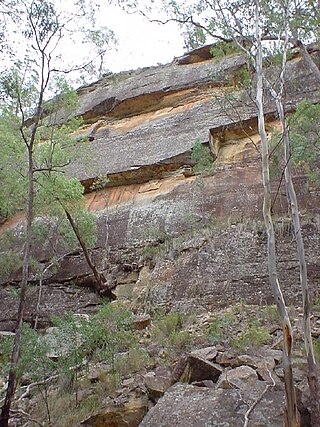
Warrumbungle National Park is a heritage listed national park located in the Orana region of New South Wales, Australia. The national park is located approximately 550 kilometres (340 mi) northwest of Sydney and contained within 23,311 hectares. The park attracts approximately 35,000 visitors per annum.

<span class="mw-page-title-main">Coonabarabran</span> Town in New South Wales, Australia

Coonabarabran is a town in Warrumbungle Shire that sits on the divide between the Central West and North West Slopes regions of New South Wales, Australia. At the 2021 census, the town had a population of 2,387,and as of 2021, the population of Coonabarabran and its surrounding area is 3,477. Local and district residents refer to the town as 'Coona'. Coonabarabran is the gateway to the Warrumbungle National Park, Siding Spring Observatory and the Pilliga Forest.

<span class="mw-page-title-main">Dunedoo</span> Town in New South Wales, Australia

Dunedoo is a village of 1,021 inhabitants situated within the Warrumbungle Shire of central western New South Wales, Australia. Dunedoo is well known to Australian travellers due to its distinctive name. The name is actually derived from a local Aboriginal word meaning "swan", which are commonly found in the area's lagoons.

<span class="mw-page-title-main">Binnaway, New South Wales</span> Town in New South Wales, Australia

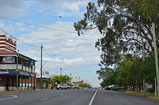
Binnaway is a small town located on the Castlereagh River in central western New South Wales near the larger centre of Coonabarabran, which is about 35 kilometres to the north. In 2016, the town had a population of 425 people. The road linking these two towns closely follows the meandering Castlereagh River. There are many pleasant areas to stop beside the road and on the river banks to have a picnic. Binnaway is also located near the similarly sized small town of Mendooran. Following local government amalgamation, the town is now located in the Warrumbungle Shire Council area which is headquartered at Coonabarabran.

<span class="mw-page-title-main">Warrumbungle Shire</span> Local government area in New South Wales, Australia

The Warrumbungle Shire is a local government area in the central western region of New South Wales, Australia. The Shire is traversed by the Newell Highway. The Warrumbungle mountain range and Warrumbungles National Park are major tourist attractions for the Shire. Its capital is Coonabarabran, a city in the southwest.

<span class="mw-page-title-main">Castlereagh River</span> River in New South Wales

The Castlereagh River is located in the central–western district of New South Wales, Australia. It is part of the Macquarie-Castlereagh catchment within the Murray–Darling basin and is an unregulated river, meaning no dams or storage have been built on it to control flows. On a map of NSW, the Castlereagh has a distinctive appearance among the north-western rivers for its fish-hook-like shape: from upstream in the north at its confluence with the Macquarie River it extends southwards to a hook-shape, flattened-out at the base, which curves to the right through to the tip of the hook in the Warrumbungle Mountains at the river's source.

<span class="mw-page-title-main">Mendooran</span> Town in New South Wales, Australia

Mendooran is a small town adjacent to the Castlereagh River in the Warrumbungle Shire of central western New South Wales, Australia. The town lies at an altitude of 271 metres above sea level, 348 kilometres west of Sydney, 75 kilometres from Dubbo and 71 kilometres southeast of Coonabarabran. At the 2021 census, Mendooran had a population of 275 people. The Castlereagh Highway also runs through the town, changing its name to Bandulla Street in the centre.

<span class="mw-page-title-main">Baan Baa</span> Town in New South Wales, Australia

Baan Baa, pronounced "barn-bar", is a village located in northern inland New South Wales, Australia in Narrabri Shire local government area and Pottinger County. It is approximately 38 kilometres south-east of Narrabri and 58 km north-west of Gunnedah on the Kamilaroi Highway. In the 2006 census, Baan Baa had a population of 211.

<span class="mw-page-title-main">Pilliga forest</span> Woodland in New South Wales, Australia

The Pilliga Forest, sometimes known as the Pilliga Scrub, constitute over 5,000 km2 of semi-arid woodland in temperate north-central New South Wales, Australia. It is the largest such continuous remnant in the state. The forest is located near the towns of Baradine and Narrabri and the villages of Pilliga and Gwabegar.

<span class="mw-page-title-main">Orana (New South Wales)</span> Region in New South Wales, Australia

Orana is a vast region in central-northern New South Wales, Australia. As of June 2015 it had an estimated population of 113,824 people. It has an area of 198,561 square kilometres (76,665 sq mi) and is the largest region in New South Wales, comprising approximately 25% of that state. The major localities include Dubbo and Cobar. This region corresponds approximately with the Australian Bureau of Statistics North Western Statistical Division.

<span class="mw-page-title-main">Gwabegar railway line</span>

The Gwabegar railway line is a railway line in the Central West and North West Slopes of New South Wales, Australia, which passes through the towns of Mudgee, Gulgong, Dunedoo, Coonabarabran and terminates at Gwabegar.

Gwabegar is a town in North Eastern New South Wales, Australia. The town is in the Narrabri Shire local government area, 625 kilometres (388 mi) north west of the state capital, Sydney. At the 2011 census, Gwabegar had a population of 344.

Kenebri is a locality in northern New South Wales, Australia.

Ulamambri is a village in north-western New South Wales, Australia.

Murrawal is a location on the now closed Gwabegar railway line in north-western New South Wales, Australia. A loop and loading bank station was located there between 1917 and 1972.

The Coonabarabran Shire was a local government area in the Orana region of New South Wales, Australia. The Shire was proclaimed on 7 March 1906 with the enactment of the Local Government (Shires) Act 1905 and was centred on the town of Coonabarabran, but also covered a wide area extending to smaller towns, such as Baradine and Binnaway. On 25 August 2004, the Shire voluntarily amalgamated with the adjoining Coolah Shire to form the Warrumbungle Shire.

Bungabah is a civil parish of Napier County in New South Wales.

Toorawandi is a civil parish of Napier County in New South Wales.

The Wooleybah Sawmill and Settlement is a heritage-listed former small settlement and sawmill at Old Wooleybah Road, Kenebri, Warrumbungle Shire, New South Wales, Australia. It was built from 1935 by the Underwood family. It is also known as Wooleybah Dead Man's Waterhole. The property is owned by Forestry Commission of NSW, an agency of the Government of New South Wales. It was added to the New South Wales State Heritage Register on 17 December 2010.

Corduroy Road Ruin Historic Site is a heritage-listed former stagecoach route and now disused road at East Coonamble Road, Curban, Gilgandra Shire, New South Wales, Australia. It was designed by n/a and built from 1850 to 1923. It is also known as Cobb & Co route. The property is owned by Gilgandra Shire Council. It was added to the New South Wales State Heritage Register on 5 October 2018.

References

  1. 1 2 Australian Bureau of Statistics (28 June 2022). "Baradine (L) (Urban Centre/Locality)". 2021 Census QuickStats. Retrieved 22 January 2024. OOjs UI icon edit-ltr-progressive.svg
  2. "Baradine". Geographical Names Register (GNR) of NSW. Geographical Names Board of New South Wales . Retrieved 10 June 2009. OOjs UI icon edit-ltr-progressive.svg
  3. Eric Rolls (1981), A Million Wild Acres: 200 Years of Man and an Australian Forest, Melbourne: Nelson, page 117.
  4. Ray Christison (2006), page 52.
  5. Ray Christison (2006), page 53.
  6. 1 2 In the North West, Newcastle Morning Herald and Miners' Advocate, 8 August 1899, page 5.
  7. Reserve From Lease, New South Wales Government Gazette (Sydney), 17 April 1862 (Issue No. 72 Supplement), page 776.
  8. Ray Christison (2006), page 53; citing J. Howlett (1965), They Came to Baradine.
  9. Joy Pickette and Mervyn Campbell (1983), Coonabarabran, As It Was in the Beginning: a History of Coonabarabran to 1900.
  10. Phoenix Auctions History. "Post Office List". Phoenix Auctions. Retrieved 24 January 2021.
  11. Baradine, Australian Town and Country Journal (Sydney), 19 August 1876, page 6.
  12. "Statistics by Catalogue Number". Australian Bureau of Statistics. Retrieved 22 January 2024.
  13. "Search Census data". Australian Bureau of Statistics. Retrieved 22 January 2024.
  14. "Outback | NSW Department of Primary Industries". Archived from the original on 24 November 2011. Retrieved 25 September 2011.
  15. "Gwabegar line description". NSWrail.net. Retrieved 21 November 2013.

Sources

Commons-logo.svg Media related to Baradine at Wikimedia Commons