
Coonabarabran is a town in Warrumbungle Shire that sits on the divide between the Central West and North West Slopes regions of New South Wales, Australia. At the 2016 census, the town had a population of 2,537. The town's nickname is "Coona".
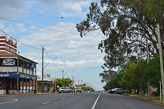
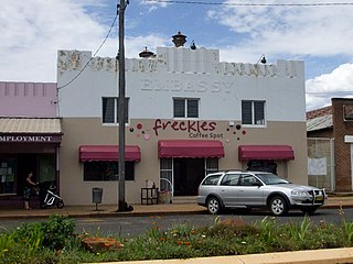
Dunedoo is a village of 747 inhabitants situated within the Warrumbungle Shire of central western New South Wales, Australia. Dunedoo is well known to Australian travellers due to its distinctive name. The name is actually derived from a local Aboriginal word meaning "swan", which are commonly found in the area's lagoons.

The Warrumbungle Shire is a local government area in the central western region of New South Wales, Australia. The Shire is traversed by the Newell Highway. The Warrumbungle mountain range and Warrumbungles National Park are major tourist attractions for the Shire. Its capital is Coonabarabran, a city in the southwest.

Erica is a town in Victoria, Australia, on Rawson Road, in the Shire of Baw Baw.

Grong Grong is a small town that is located in the Riverina region of New South Wales, Australia. The town is situated on the Newell Highway, 23 kilometres (14 mi) east of Narrandera in the Shire of Narrandera.

Bethungra is a locality in Junee Shire in the South West Slopes region of New South Wales, Australia situated on the Olympic Highway about 13 kilometres northeast of Illabo and 24 kilometres southwest of Cootamundra.

Kamarah, is a village community in the central north part of the Riverina. It is situated by road, about 11 kilometres west of Ardlethan and 12 kilometres east of Moombooldool. At the 2006 census, Kamarah had a population of 130 people.

The Gwabegar Railway Line is a railway line in the Central West and North West Slopes of New South Wales, Australia, which passes through the towns of Mudgee, Gulgong, Dunedoo, Coonabarabran and terminates at Gwabegar.

Gwabegar is a town in North Eastern New South Wales, Australia. The town is in the Narrabri Shire local government area, 625 kilometres (388 mi) north west of the state capital, Sydney. At the 2011 census, Gwabegar had a population of 344.

Jennings is a town on the Northern Tablelands region of New South Wales, Australia. The town is located in the Tenterfield Shire local government area, 718 kilometres (446 mi) from the state capital, Sydney and 256 kilometres (159 mi) from Brisbane. It is separated by the state border from its neighbouring town of Wallangarra in Queensland. At the 2011 census, Jennings had a population of 211. The New England Highway and the Main North railway line cross the state border at Jennings. The town was named for Sir Patrick Jennings, the first Roman Catholic Premier of New South Wales.
Baradine is a small town in north western New South Wales, Australia. At the 2006 census, Baradine had a population of 593.

Wollun is a small rural community about 26 kilometres north-west of Walcha and is included in the Uralla Shire local government area of the Northern Tablelands region of New South Wales, Australia.
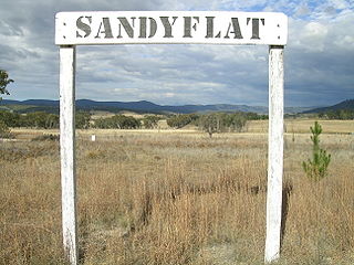
Sandy Flat is a historic locality on the Northern Tablelands in the New England region of New South Wales, Australia. This locality is situated on New England Highway and the former Main North Railway line about 20 kilometres south of Tenterfield. At the 2011 census, Sandy Flat had a population of 209 people.

Brooloo is a rural town and locality in the Gympie Region, Queensland, Australia. In the 2016 census the locality of Brooloo had a population of 348 people.
Ardglen is a village on the Main North railway line and close to the New England Highway on the North West Slopes region of New South Wales, Australia.

Merrygoen is a small township in north-western New South Wales, Australia. The town is a junction point between railway lines to Troy Junction on the Coonamble railway line, and the Gwabegar railway line. The railway station is now closed, however wheat silos and several sidings remain in use. Merrygoen is in the Gap to Dubbo section of the Intrastate Network managed by the Australian Rail Track Corporation.

Gherang is a small rural township in Victoria, Australia. It is in the Surf Coast Shire local government area, and is located on the northern edge of the Great Otway National Park and the Anglesea Heath. At the 2006 census, Gherang had a population of 370. The area is mostly farmland, although there has been some rural residential subdivision. Quarries in the area produce good quality gravel which is mostly used for roads.
Pennyroyal is a rural locality in Victoria, Australia. Most of the locality is situated in the Surf Coast Shire; a small section is situated in the Shire of Colac Otway. In the 2016 census, Pennyroyal had a population of 86.

Hoya is a locality in the Scenic Rim Region, Queensland, Australia. In the 2016 census, Hoya had a population of 220 people.
