Dunedoo is a village of 1,021 inhabitants situated within the Warrumbungle Shire of central western New South Wales, Australia. Dunedoo is well known to Australian travellers due to its distinctive name. The name is actually derived from a local Aboriginal word meaning "swan", which are commonly found in the area's lagoons.

Talbragar River, a perennial stream that is part of the Macquarie catchment within the Murray–Darling basin, is located in the Orana district of New South Wales, Australia.

Gulgong is a 19th-century gold rush town in the Central Tablelands and the wider Central West regions of the Australian state of New South Wales. The town is situated within the Mid-Western Regional Council local government area. It is located about 300 km (190 mi) north west of Sydney, and about 30 km north of Mudgee along the Castlereagh Highway. At the 2021 census, Gulgong had a population of 2,680.

Moura is a rural town and locality in the Shire of Banana in Central Queensland, Australia. It services the surrounding coal mining and rural activities. It is situated approximately 65 kilometres (40 mi) west of Biloela on the Dawson Highway, 186 kilometres (116 mi) west of the port city of Gladstone, and 171 kilometres (106 mi) south west of Rockhampton.

Binnaway is a small town located on the Castlereagh River in central western New South Wales near the larger centre of Coonabarabran, which is about 35 kilometres to the north. In 2021, the town had a population of 399 people. The road linking these two towns closely follows the meandering Castlereagh River. There are many pleasant areas to stop beside the road and on the river banks to have a picnic. Binnaway is also located near the similarly sized small town of Mendooran. Following local government amalgamation, the town is now located in the Warrumbungle Shire Council area which is headquartered at Coonabarabran.

The Warrumbungle Shire is a local government area in the central western region of New South Wales, Australia. The Shire is traversed by the Newell Highway. The Warrumbungle mountain range and Warrumbungles National Park are major tourist attractions for the Shire. Its seat is located in Coonabarabran, a town in the southwest.

The Mid-Western Regional Council is a local government area in the Central West region of New South Wales, Australia. The area is located adjacent to the Castlereagh Highway that passes through the middle of the area in an approximate southeast–northwest direction.

Rylstone is a small town in New South Wales, Australia, in the Central Tablelands region within the Mid-Western Regional Council local government area. It is located on the Bylong Valley Way road route. At the 2021 census, Rylstone had a population of 904.

The Gwabegar railway line is a railway line in the Central West and North West Slopes of New South Wales, Australia, which passes through the towns of Mudgee, Gulgong, Dunedoo, Coonabarabran and terminates at Gwabegar.
Tallawang is an historical locality north of Gulgong in central western New South Wales, Australia. The place name is derived from an aboriginal word for "apple gum".

Stratford is a rural locality in the Mid-Coast Council local government area in the Hunter Region of New South Wales, Australia. The largest population centre in the area is the town of Stratford, which is approximately 14 kilometres (9 mi) south of Gloucester and 109 km (68 mi) north of Newcastle. Stratford, which is next to the Avon River, is on Bucketts Way, 66 km (41 mi) from the Pacific Highway, the nearest major highway.

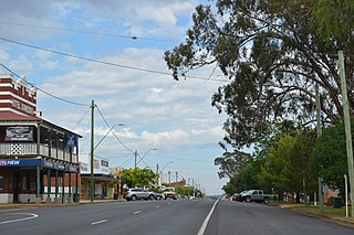
Leadville is a town in New South Wales, Australia. The town is located in the Warrumbungle Shire local government area, 376 kilometres (234 mi) north west of the state capital, Sydney. At the 2016 census, Leadville and the surrounding area had a population of 169.
Leo Mervyn Nott was an Australian politician and a member of the New South Wales Legislative Assembly between 1953 and 1968 and again between 1971 and 1973. He was a member of the NSW Branch of the Labor Party.
Denison Town is a ghost town in New South Wales, Australia. It was established in the 1850s and is thought to have been named after the Governor of New South Wales, Sir William Thomas Denison. It was located about 11 kilometres (7 mi) from the present town of Dunedoo. In its heyday, Denison Town consisted of an inn, post office, church and cemetery, and was the occasional venue for sittings of the Local Court. Local industries included the farming of wheat, sheep and cattle, alongside sporadic prospecting for silver ore.
Coolaburragundy River, a perennial stream that is part of the Talbragar catchment within the Murray–Darling basin, is located in the Orana district of New South Wales, Australia.
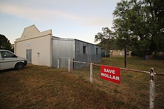
Wollar is a village in New South Wales, Australia. The town is located 316 kilometres (196 mi) north west of the state capital Sydney and 48 kilometres (30 mi) north-east of the regional centre of Mudgee, near the Goulburn River National Park. At the 2006 census, Wollar and the surrounding region had a population of 304. By the 2016 census the village of Wollar and district was reduced to 69 persons living in 50 private dwellings.
Coolah Shire was a local government area in New South Wales, Australia from 1906 to 1994.
The Coonabarabran Shire was a local government area in the Orana region of New South Wales, Australia. The Shire was proclaimed on 7 March 1906 with the enactment of the Local Government (Shires) Act 1905 and was centred on the town of Coonabarabran, but also covered a wide area extending to smaller towns, such as Baradine and Binnaway. On 25 August 2004, the Shire voluntarily amalgamated with the adjoining Coolah Shire to form the Warrumbungle Shire.

Talbragar Shire was a local government area in the Orana region of New South Wales, Australia.
Cobbora Shire was a local government area in the Orana region of New South Wales, Australia.
