
Dubbo is a city in the Orana Region of New South Wales, Australia. It is the largest population centre in the Orana region, with a population of 43,516 at June 2021.

Harden–Murrumburrah is a township and community in the Hilltops Region and is located in the South West Slopes of New South Wales in Australia and is adjacent to both the Canberra region of the Australian Capital Territory and the Riverina Region in the southwest area of NSW. The town is a twin town between Harden and Murrumburrah.

Wellington is a city in the Central Western Slopes region of New South Wales, Australia, located at the junction of the Wambuul Macquarie and Bell Rivers. It is within the local government area of Dubbo Regional Council. The city is 362 kilometres (225 mi) northwest of Sydney on the Mitchell Highway and Main Western Railway, and 50 km southeast of Dubbo, the main centre of the Central Western Slopes region.

Towradgi is a small beach-side suburb approximately 5 km (3.1 mi) north of Wollongong, New South Wales, Australia. Towradgi is derived from the Dharawal word Kow-radgi, meaning "guardian of the sacred stones". On an early map it was called Towroger. Towradgi is served by electric trains at Towradgi railway station, opened in 1948.

Gowanbrae is a suburb in Melbourne, Victoria, Australia, 13 km (8.1 mi) north-west of Melbourne's Central Business District, located within the City of Merri-bek local government area. Gowanbrae recorded a population of 2,971 at the 2021 census.

Cullen Bullen is a village in New South Wales, Australia. It is located on Mudgee Road, 168 km north-west of Sydney, 28 km north of Lithgow. At the 2016 census, Cullen Bullen had a population of 279 people, up from 198 ten years earlier. The Cullen Bullen village is sustained by local mines and the Mount Piper Power Station.

Grenfell is a town in Weddin Shire in the Central West of New South Wales, Australia. It is 370 km (230 mi) west of Sydney. It is close to Forbes, Cowra and Young. At the 2011 census, Grenfell had a population of 1,996. The town is served daily by connecting NSW TrainLink services from Sydney via Bathurst and Lithgow. Grenfell is approximately 5 hours from Sydney and 2 1/2 hours from Canberra.
Yarramundi is a suburb of Sydney, in the state of New South Wales, Australia. Yarramundi is located 69 kilometres west of the Sydney central business district, in the local government area of the City of Hawkesbury.

Cowan is a small town and suburb near Sydney, in the state of New South Wales, Australia, approximately 40 kilometres (25 mi) north of the Sydney central business district, in the local government area of Hornsby Shire. Cowan shares the postcode of 2081 with Berowra. Brooklyn, which lies 6 kilometres (3.7 mi) to the north-east of Cowan, is considered the northernmost suburb of the Greater Sydney Metropolitan Area.

Nambucca Heads is a town on the Mid North Coast of New South Wales, Australia in the Nambucca Valley. It is located on a ridge, north of the estuary of the Nambucca River near the Pacific Highway. Its 2011 population was 6,137, including 602 (9.7%) indigenous persons and 5,180 (83.3%) Australian-born persons in the Shire. The place name is derived from an Gumbaynggirr word Ngambagabaga. Clement Hodgkinson asked two Ngamba men what the name of the area was they responded to Nyambagabaga as the spot they were standing was a bend in the river where a Ngamba giant was speared in the leg in the Dreaming. This location is the Foreshore Caravan Park now. Ngamba is a subsection of Gumbaynggirr Nation & Baga Baga means Knee. This was later interpreted as Nambucca. It is a popular holiday and retirement destination.

Stuart Town, formerly known as Ironbark, is a small town on the Central Western Slopes of New South Wales, Australia within Dubbo Regional Council. It is located 317 kilometres (197 mi) north-west of the state capital, Sydney. At the 2011 census, Stuart Town had a population of 487. The area around the town is rich in cattle farming and orchards, so the town serves as a service centre to that area.

Woodford is a village in the Blue Mountains in New South Wales, Australia, about 90 kilometres west of Sydney. Its elevation is 609 metres (1,998 ft) above sea level. It is situated on the Great Western Highway and has a railway station on the Main Western railway line served by NSW TrainLink's Blue Mountains services. At the 2016 census, Woodford had a population of 1,934.

Mogriguy is a small village located approximately 30 km north of Dubbo in central west New South Wales, Australia. Situated on the Mogriguy Road, and the Dubbo Coonamble branch railway line, it has a population of about 25.
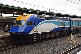
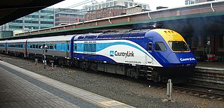
The New South Wales XPT is a class of diesel-powered passenger trains built by Comeng and ABB Transportation. Based on the British Rail designed Intercity 125 High Speed Train, each XPT set is made up of two XP locomotives in a push-pull formation coupled to between four and seven carriages. The first sets entered service under the State Rail Authority in 1982 and now operate under NSW TrainLink, running on long-distance regional and interstate North Coast, Main Western and Main Southern lines throughout New South Wales and interstate into Victoria and Queensland.
Rydal is a small rural village in New South Wales, Australia.
Sodwalls is a small hamlet in New South Wales, Australia
Cycling in the Australian state of New South Wales is a common form of recreation. In 2009, cycling was the fifth-most popular sports/physical activity in NSW.
The Central West Express is an Australian passenger train operating on the Main Western line in New South Wales from Sydney to Dubbo.
The Western Mail was an Australian passenger train that ran from Sydney to Dubbo and Parkes from 1973 until November 1988.

The Dubbo Regional Council is a local government area located in the Central West and Orana regions of New South Wales, Australia. The council was formed on 12 May 2016 through a merger of the City of Dubbo and Wellington Council as part of a widespread council amalgamation program. It was initially named Western Plains Regional Council for almost four months, and its name was changed to Dubbo Regional Council on 7 September 2016.

