Ophir is the name of a locality in New South Wales, Australia in Cabonne Shire.
Tintinhull is a tiny hamlet about 10 kilometres east of Tamworth, New South Wales, Australia. It is situated between Nemingha and Kootingal, and lies on the New England Highway. The locality is 466 km from Sydney, on the Main North Rail Line which opened in 1885 and closed in December 1971.

Dayboro is a rural town and locality in the City of Moreton Bay, Queensland, Australia. In the 2021 census, the locality of Dayboro had a population of 2,376 people.

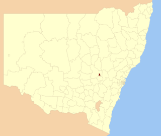
Cabonne Council is a local government area in the Central West region of New South Wales, Australia. The Shire is located adjacent to the Mitchell Highway and the Broken Hill railway line, partly surrounding the City of Orange. The administrative centre is located at Molong.

Cumnock is a small town in New South Wales, Australia. It is located on the now closed cross-country railway line from Molong to Dubbo. The town is located in Cabonne Shire. At the 2011 census, Cumnock had a population of 275 people. In the 2021 census the "Suburbs and Localities" of Cumnock had a population of 491.

Blayney Shire is a local government area in the Central West region of New South Wales, Australia. The Shire is located adjacent to the Mid-Western Highway and the Main Western railway line, and is centred on the town of Blayney.
The City of Orange is a local government area in the Central West region of New South Wales, Australia. Based in Orange, the area is located adjacent to the Mitchell Highway and the Main Western railway line.
Mullion Creek is a locality in the central west of New South Wales, Australia, in Cabonne Shire, near Orange.
Clarendon is a rural locality in the Somerset Region, Queensland, Australia. In the 2021 census, Clarendon had a population of 232 people.

Yeoval is a small village in the Central Western district of New South Wales, Australia. The town lies in Cabonne Shire. However, a small part lies over Buckinbah Creek in Wellington Shire which is referred to as North Yeoval. Yeoval is located between Dubbo and Orange. The town was the childhood home of Australian poet Banjo Paterson, who lived on the nearby Buckinbah property, and many of his poems reflect the area. A Banjo Paterson Museum is open to visitors.
The Shire of Broomehill-Tambellup is a local government area in the Great Southern region of Western Australia, 320 kilometres (200 mi) south-southeast of the state capital, Perth. The Shire covers an area of 2,609.1 square kilometres (1,007.4 sq mi), and its seat of government is the town of Tambellup. It came into existence in 2008 through the amalgamation of the former Shire of Broomehill and Shire of Tambellup.
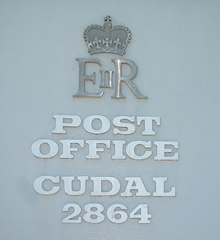
Cudal is a town in the Central West region of New South Wales, Australia, on the traditional lands of the Wiradjuri people. Cudal is in the Cabonne Shire Council local government area, 296 kilometres (184 mi) west of the state capital, Sydney. The town was first surveyed in 1867. Running through the town is "Boree Creek". Platypodes are common in the Boree Creek, giving Cudal the catchline 'home of the platypus' on signs entering the town. The place name, Cudal, could have derived from an Aboriginal word meaning 'flat'. At the 2011 census, Cudal had a population of 339. Industry and commerce in Cudal is a mixture of retail, government services, and agriculture. Cudal is surrounded by fertile basalt soils, the result of lava flows from Gaanha Bula Mount Canobolas, 30 kilometres to the east.

Crossdale is a rural locality in the Somerset Region, Queensland, Australia. In the 2021 census, Crossdale had a population of 68 people.

Rollands Plains is a village and bounded rural locality in Mid North Coast of New South Wales, Australia.
Narridy is a locality in the Mid North region of South Australia, situated within the Northern Areas Council.
Emu Downs is a rural locality in the Mid North region of South Australia, situated in the Regional Council of Goyder.
Obley, New South Wales located at 32°44′54″S 148°36′04″ is a hamlet of Cabonne Shire Council, New South Wales.
Caboonbah is a rural locality in the Somerset Region, Queensland, Australia. In the 2021 census, Caboonbah had a population of 13 people.

Biarra is a rural locality in the Somerset Region, Queensland, Australia. In the 2021 census, Biarra had a population of 270 people.

Braemore is a rural locality in the Somerset Region, Queensland, Australia. In the 2021 census, Braemore had a population of 131 people.
