Timber Creek, Northern Territory

Last updated

Timber Creek
Northern Territory
Australia Northern Territory location map.svg
Red pog.svg
Timber Creek
Coordinates 15°38′43″S130°28′28″E / 15.64528°S 130.47444°E / -15.64528; 130.47444
Population278 (2021 census) [1]
Established1898
Postcode(s) 0852
Location
LGA(s) Victoria Daly Region
Territory electorate(s) Daly
Federal division(s) Lingiari

Timber Creek, traditionally known as Makalamayi, is an isolated small town on the banks of the Victoria River in the Northern Territory of Australia. The Victoria Highway passes through the town, which is the only significant settlement between the Western Australia border and the town of Katherine to the east. Timber Creek is approximately 600 kilometres (370 mi) south of Darwin, in an area known for its scenic escarpments and boab trees.

Contents

History

Pre-European history

The Ngaliwurru and Nungali peoples, two Aboriginal Australian peoples, are the original inhabitants and traditional owners of the lands surrounding the town. [2] Their way of life remained unchanged for tens of thousands of years until first contact with Europeans in the 19th century. The traditional name for the locality is "Makalamayi". [3] [4] [5]

1855: European exploration

In September 1855, Augustus Charles Gregory and a party of 19 men reached the mouth of the Victoria River. The party's schooner, Tom Tough, proceeded along the river, landing near the present town of Timber Creek and a base camp for the expedition was established. [6] Gregory named a nearby stream "Timber Creek" on 24 November while seeking timber to make repairs to the boat. [7]

Gregory inscribed of the dates of this expedition on a large boab tree near the original campsite, located approximately 15 kilometres (9.3 mi) from the present town; the tree, and the inscription, can still be seen today, and is known as Gregory's Tree. [8] [9] The scientific name of the boab, Adansonia gregorii , was named in honour of Gregory. [10]

20th century development

A police station was constructed in 1898, and substantially upgraded in 1908 as river traffic grew to service pastoral properties being established in the area. [11] In 1911, a depot was established to service the river trade. [7] Historical records from the late 19th and early 20th century indicate there were ongoing tensions, and isolated incidents of violence between pastoralist and Aboriginal residents in the area at during this time. [4]

During World War II growing concerns over a Japanese invasion of northern Australia led to the formation of the 2/1st North Australia Observer Unit, a highly mobile reconnaissance unit led by local Aboriginal guides who knew the local landscape. The role of this unit was to report any enemy landings on isolated areas of the coastline. [12] The unit was active in the Timber Creek and Victoria River areas, recognised in 1998 with a memorial to the "Nackeroos" – the nickname for those who served with this unique unit – being constructed near the town. [13]

Traffic passing through Timber Creek increased following the completion of the Ord River Diversion Dam at Kununurra, Western Australia in 1963 [14] and subsequent construction of the road bridge in 1970 across the Victoria River, 82 kilometres (51 mi) east of the town, and sealing of the Victoria Highway in 1974. [15] Timber Creek was proclaimed a town on 20 June 1975. [7]

In 1996, the Department of Defence purchased Bradshaw Station, a large cattle property in the vicinity of Timber Creek. This land subsequently became Bradshaw Field Training Area, an 8700 km2 live fire training facility. In 2002, the 270m long Bradshaw Bridge opened, providing road access to the training area from the Victoria Highway at Timber Creek. [16]

1997–2019: Griffiths decision and appeals

Ngaliwurru and Nungali lands surrounding Timber Creek were the subject of the landmark Griffiths decision in the High Court of Australia. The case (Griffiths v Minister for Lands, Planning and Environment) involved an appeal by the traditional owners, represented by Alan Griffiths and William Gulwin, against the Northern Territory Government's attempted sale in 1997 of vacant Crown land for the purposes of commercial development. In the course of doing so, the native title would be compulsorily acquired under the Lands Acquisition Act 1989 (NT) from the traditional owners by a government minister, for the commercial benefit of a private third party. Due to a change in government following the 2001 Northern Territory elections, the development did not proceed and the native title was not acquired, but the case proceeded in the courts. [17] The final decision handed down in 2008 found that the provisions under the Lands Acquisition Act meant the Minister could legitimately acquire land for any purpose, extinguishing native title and interests in the land granted under the Native Title Act (1993). By the time of the decision the Northern Territory Government had already changed the legislation to prevent this or future compulsory acquisition of lands subject to native title. [17]

In September 2018, the High Court of Australia came to the Northern Territory for the first time ever, to hear an appeal against earlier decisions. Chief Justice Susan Kiefel presided in Northern Territory of Australia v Griffiths (D1-D3/2018). [5] A group of traditional owners of Timber Creek (Ngaliwurru and Nungali peoples) earlier claimed compensation for the loss of native title rights that had been extinguished after the Crown acquired land without their consent. [18] In 2016, in Griffiths v Northern Territory of Australia (No 3), [5] the trial judge had awarded a total of $3.3 million dollars compensation across the three categories. In 2017, the Full Federal Court, on appeal, reduced that to around $2.9 million. The full claim is for almost $5 million. [18] In 2019, in Northern Territory v Mr Griffiths and Lorraine Jones , the High Court awarded a total of $2.5m "in compensation for both economic and cultural loss, including interest". Described as "the most significant [case]… since Mabo", the High Court ruled for the first time on compensation for the extinguishment of native title in Australia. [19]

2022–2023: Tropical Cyclone Ellie

Tropical Cyclone Ellie caused extensive flooding in Timber Creek, after it moved through the Northern Territory first from 22 December 2022, and then again after it crossed the border back into NT from Western Australia in early January. It was described as once-in-50-year flooding. Remote communities in the area had been cut off as roads remained closed. Victoria Daly Region Mayor Brian Pedwell said that better emergency procedures needed to be developed to help the community cope with future such disasters, after evacuees had to take shelter on a basketball court before being to a defence base. [20]

Climate

Timber Creek is a tropical savanna climate (Köppen climate classification Aw) with distinct wet and dry seasons. The annual rainfall is 979mm with the heaviest falls occurring during the wet season months November – April. High humidity and overnight temperatures as well as large thunderstorms characterise this season. The Victoria River is prone to flooding during these months. The dry season months, May–October, see minimal rainfall, blue skies, less humidity and cooler overnight temperatures.

Climate data for Timber Creek
MonthJanFebMarAprMayJunJulAugSepOctNovDecYear
Mean daily maximum °C (°F)35.9
(96.6)
35.1
(95.2)
35.4
(95.7)
35.2
(95.4)
32.9
(91.2)
30.3
(86.5)
30.6
(87.1)
32.9
(91.2)
36.5
(97.7)
38.3
(100.9)
38.4
(101.1)
37.1
(98.8)
34.9
(94.8)
Mean daily minimum °C (°F)24.9
(76.8)
24.6
(76.3)
23.5
(74.3)
21.1
(70.0)
18.3
(64.9)
15.4
(59.7)
14.7
(58.5)
16.0
(60.8)
20.6
(69.1)
24.0
(75.2)
25.1
(77.2)
25.4
(77.7)
21.1
(70.0)
Average precipitation mm (inches)228.7
(9.00)
233.1
(9.18)
163.7
(6.44)
30.5
(1.20)
8.2
(0.32)
2.8
(0.11)
2.0
(0.08)
0.6
(0.02)
5.9
(0.23)
29.0
(1.14)
83.0
(3.27)
177.2
(6.98)
978.7
(38.53)
Average rainy days14.014.110.22.30.70.30.20.10.83.07.211.664.5
Source: [21]

Demographics

There were 278 persons resident in Timber Creek at the 2021 census. This was an increase of 11.6% from the 249 residents reported at the 2016 census. 54.8% of the population was male and 45.2% female. 155 persons (56%) identified as Aboriginal and/or Torres Strait Islanders. The median age of residents was 33 years, with 75% of the population was born in Australia. [1]

The most common languages spoken in the town were English and Ngaliwurru. Of those who reported a religious affiliation, the largest group was Pentecostal (22%). While median weekly incomes were lower for individuals than both the Northern Territory and national levels, household incomes were higher than the national median in Timber Creek. [1]

Attractions

The nearest official visitor centre is the Katherine Visitor Information Centre, on the Stuart Highway in Katherine. [22]

Judbarra National Park

Judbarra - Gregory National Park Judbarra - Gregory National Park.jpg
Judbarra - Gregory National Park

Judbarra National Park, the largest part of which is situated to the south-west of Timber Creek, encompasses 13,000 km2 (5,000 sq mi) of wilderness, covering tropical and semi-arid landscapes. It is significant for the natural beauty and traces of Aboriginal culture throughout the park. It is open all year round for fishing, camping and four-wheel drive activities. The park was formerly known as Gregory National Park, but on 21 October 2011, it was announced that under a joint management plan with the traditional owners, the park would be dual-named "Judbarra / Gregory" for ten years. The plan aims to preserve the unique cultural heritage found at this place. From 2021, its official name became Judbarra National Park. [23]

Gregory's Tree

"Gregory's Tree" by the Victoria River, west of the town Gregory Tree.JPG
"Gregory's Tree" by the Victoria River, west of the town

"Gregory's Tree" is a large boab tree on which explorer A.C. Gregory 's party inscribed the arrival and departure dates of the 1855–56 expedition to explore the Victoria River and surrounds. The tree is located at the northernmost point of the Gregory National Park at the expedition's original campsite by the river bank and is a short drive from the Victoria Highway and is well signposted. The site itself has boardwalks and information signs detailing its history. The tree is registered both as a heritage place and an Aboriginal sacred site. [24] [25] [10]

Timber Creek Police Station Museum

The first police station in Timber Creek was established in 1898, comprising a hut and goat paddock. It was upgraded to iron and steel in 1908, and this building is now heritage-listed and serves as a museum with local history and law enforcement exhibits, known as the Timber Creek Police Station Museum. [26] The main building was restored in the 1980s. The museum precinct includes outbuildings and grave sites. The buildings are maintained by the National Trust of Australia (Northern Territory). [27]

Other attractions

Other attractions in the town include the Bronco Panel Sculpture, the Timber Creek Heritage Trail, Timber Creek Lookout, and memorial plaques dedicated to the "Nackeroos". Fishing for barramundi is a popular pastime, particularly near the Big Horse Creek campsite, around 10 km (6.2 mi) west of the town. [22]

Governance and infrastructure

The Timber Creek office of the Victoria Daly Regional Council serves the nearby outstations and communities of Muruning, Myatt, Gulardi, Gilwi as well as communities further away, such as Bulla, Amanbidji, and Menngen. The office employs 18 staff members, who are responsible for looking after parks and gardens, waste management, and administration; as well as delivering services such as community night patrol, aged care, and sports & recreation. [28]

The Ngaliwurru-Wuli Aboriginal Corporation (NWAC) was established around 1986 or 1987 the Associations Act (NT) to serve as an outstation/ homelands resource centre. In 2019 it transitioned to become an Aboriginal corporation, under the Corporations (Aboriginal and Torres Strait Islander) Act 2006 . Its work includes building and infrastructure maintenance, municipal and essential services, as well as civil and construction work to other government departments and the general public. It also operates the local Centrelink agency. A mechanical workshop situated on Wilson Street is owned and operated by the NWAC. [29] [30]

Timber Creek has an automated power station capable of generating 1MW for the community. The generator was installed in 2005 and owned and operated by the government-owned Power and Water Corporation. [31] [ citation needed ]

Facilities

The Timber Creek School, the only school in the town, is a public school providing preschool, primary, and middle school classes. In the 2021 Australian census, there were 31 students enrolled at the school in August 2021. [32]

The Timber Creek Health Centre, run by the Katherine West Health Board (KWHB), is staffed Monday–Friday by a health centre coordinator, GP, remote area nurses, and support staff. Various specialist services and KWHB program visit the centre on a regular basis. [33]

The Timber Creek Travellers Rest (formerly Timber Creek Hotel and Circle F Caravan Park [34] ) is a large roadhouse, which includes a general store, petrol outlet, caravan park and holiday cabins, along with a swimming pool for customers. [35] [36]

There is also an Aboriginal-owned enterprise, Wirib Tourism Park, which is owned by the Gunamu Aboriginal Corporation. It has a general store (where bread is baked daily), camping and caravan sites, and holiday cabins. [37]

Timber Creek is a stop for interstate coach services on the Darwin to Broome route. Buses stop at the roadhouse on the Victoria Highway. [38] [39]

There is an airstrip a few kilometres to the west of town, Timber Creek Airport.[ citation needed ]

Bradshaw Field Training Area

The Bradshaw Field Training Area (BFTA) is a large army training area occupies approximately 870,000 ha (2,100,000 acres), starting 500 m (1,600 ft) north of Timber Creek, [40] on the traditional lands of the Ngaliwurru, Jaminjung, and Nungali people. They were initially worried about talking to uniformed personnel, and thought that the army may drop bombs and disregard their sacred sites. However, the ADF engaged with local people through the Bradshaw Liaison Committee, and over time both sides developed a trusting and respectful partnership. Sites of cultural significance have been mapped by the ADF and their personnel made aware of them. The army personnel have also learned more about the local Aboriginal Australians, in particular their connection to Country. [41]

An Indigenous Land Use Agreement (ILUA) ensures protection of and ongoing access to the cultural sites for cultural purposes. These were kept private for many years, but since around 2003 the trust and friendships with army personnel evolved to a point that the traditional owners started including soldiers and the US Marines in their cultural activities, and some have become friends. The Marines are part of the Marine Rotational Force based in Darwin. [41]

The Timber Creek economy is improved with the influx of ADF personnel, as they need occasional accommodation in the town, as well as the provision of food and fuel. New local businesses have been set up which provide employment for local people. In addition, as part of the ILUA, funding has been made available for local children to attend boarding schools as well as adults going to university. [41]

In September 2021, residents of Timber Creek were shown around the base during Exercise Koolendong, which gave employment to the 18 staff at the Aboriginal-owned Bradshaw & Timber Creek Contracting & Resource Company. MRF-D commanding officer, Colonel David Banning, expressed his appreciation to the traditional owners for their hospitality and ongoing support of the army. [42]

Related Research Articles

<span class="mw-page-title-main">Northern Territory</span> Territory of Australia

The Northern Territory is an Australian territory in the central and central northern regions of Australia. The Northern Territory shares its borders with Western Australia to the west, South Australia to the south, and Queensland to the east. To the north, the territory looks out to the Timor Sea, the Arafura Sea and the Gulf of Carpentaria, including Western New Guinea and other islands of the Indonesian archipelago.

<span class="mw-page-title-main">Protected areas of the Northern Territory</span>

The protected areas of the Northern Territory consists of protected areas managed by the governments of the Northern Territory and Australia and private organisations with a reported total area of 335,527 square kilometres (129,548 sq mi) being 24.8% of the total area of the Northern Territory of Australia.

<span class="mw-page-title-main">Judbarra / Gregory National Park</span> Protected area in the Northern Territory, Australia

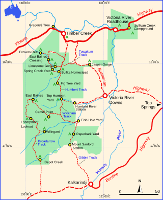
Judbarra National Park, formerly Gregory National Park and Judbarra / Gregory National Park, is a national park in the Northern Territory of Australia, 359 km (223 mi) south of Darwin.

<span class="mw-page-title-main">Katherine, Northern Territory</span> Town in the Northern Territory, Australia

Katherine is a town in the Northern Territory of Australia. It is situated on the Katherine River, after which it is named, 320 kilometres (200 mi) southeast of Darwin. The fourth largest settlement in the Territory, it is known as the place where "The outback meets the tropics". Katherine had an urban population of approximately 6,300 at the 2016 Census.

<i>Adansonia gregorii</i> Species of tree

Adansonia gregorii, commonly known as the boab and also known by a number of other names, is a tree in the family Malvaceae, endemic to the northern regions of Western Australia and the Northern Territory of Australia.

<span class="mw-page-title-main">Augustus Charles Gregory</span> Australian politician

Sir Augustus Charles Gregory was an English-born Australian explorer and surveyor. Between 1846 and 1858 he undertook four major expeditions. He was the first Surveyor-General of Queensland. He was appointed a lifetime Member of the Queensland Legislative Council.

<span class="mw-page-title-main">Victoria Highway</span> Highway in the Northern Territory and WA

The Victoria Highway links the Great Northern Highway in Western Australia with the Stuart Highway in the Northern Territory. The highway is a part of the Perth–Darwin National Highway link. It is signed as National Highway 1, and is part of Highway 1, a circular route around the country. It is 555 kilometres (345 mi) long, and most of the route – some 470 kilometres (290 mi) – lies within the Northern Territory. In some areas it runs in parallel with the Northern Territory's Victoria River, from which its name originates.

The Northern Land Council (NLC) is a land council representing the Aboriginal peoples of the Top End of the Northern Territory of Australia, with its head office in Darwin.

<span class="mw-page-title-main">Victoria River (Northern Territory)</span> River in the Northern Territory, Australia

The Victoria River is a river in the bioregion of Victoria Bonaparte in the Northern Territory of Australia. It flows for 560 kilometres (350 mi) from its source south of the Judbarra / Gregory National Park to the Joseph Bonaparte Gulf in the Timor Sea.

<span class="mw-page-title-main">Daly River, Northern Territory</span> Suburb of Victoria Daly Region, the Northern Territory, Australia

Daly River is a town adjacent to the Daly River in the Northern Territory of Australia. At the 2006 census, Daly River had a population of 468. The town is part of the Victoria Daly Region local government area. The area is popular for recreational fishing, being regarded as one of the best places to catch Barramundi in Australia.

<span class="mw-page-title-main">Lajamanu, Northern Territory</span> Town in the Northern Territory, Australia

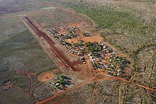
Lajamanu, formerly known as Hooker Creek Native Settlement or just Hooker Creek, is a small town of the Northern Territory of Australia. It is located around 560 km (350 mi) from Katherine and approximately 890 km (550 mi) from Darwin. At the 2016 Australian census, Lajamanu had a population of 606, of whom 89.3 percent are of Aboriginal and/or Torres Strait Islander origin, chiefly Warlpiri people.

Jaminjung is a moribund Australian language spoken around the Victoria River in the Northern Territory of Australia. There seems to be a steady increase in the number of speakers of the language with very few people speaking the language in 1967, about 30 speakers in 1991, and between 50 and 150 speakers in 2000.

<span class="mw-page-title-main">Bradshaw Field Training Area</span>

The Bradshaw Field Training Area (BFTA) is a large army training area located 600 km (370 mi) south of Darwin in the Northern Territory of Australia. It is used for training by the Australian Army as well as an as an Australia-U.S. combined training centre, with the U.S. Marines stationed at Darwin.

The Wickham River is an ephemeral river, located in the Victoria Bonaparte bioregion of the Northern Territory in Australia.

<i>Ficus coronulata</i> Species of fig

Ficus coronulata, commonly known as the peach-leaf fig, and in the Northern Territory as river fig and crown fig, is one of several fig species commonly known as sandpaper figs. It is native to Western Australia and the Northern Territory.

The Jamindjung, also spelt Djamindjung, are an indigenous Australian people of the Northern Territory.

The Ngaliwurru are an indigenous Australian people of the Northern Territory.

<i>Northern Territory v Mr Griffiths and Lorraine Jones</i> Law case in the Northern Territory, Australia

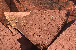
Northern Territory v Mr A. Griffiths (deceased) and Lorraine Jones on behalf of the Ngaliwurru and Nungali Peoples [2019] HCA 7 is an Australian native title court case that was heard in the High Court of Australia. This case was an appeal by the Northern Territory and the Commonwealth of Australia of the decision handed down by the Full Court of the Federal Court of Australia in Northern Territory of Australia v Griffiths [2017] FCAFC 106. The High Court of Australia ruled to reduce the amount of compensation awarded to the Ngaliwurru People and the Nungali People by the Full Court of the Federal Court of Australia. This compensation had been granted to the Ngaliwurru and Nungali Peoples as a remedy for deeds taken by the Northern Territory Government that were previously established by the judicial system to have extinguished native title. The total amount of compensation awarded was reduced from $2,899,446 to $2,530,350. This compensation had been awarded for the monetary and non-monetary loss, as well as interest, associated with the extinguishment of native title. The decision made by the High Court meant the appeals made by the Northern Territory and the Commonwealth were "allowed in part". The case of Northern Territory v Mr Griffiths and Lorraine Jones has been labelled one of the most significant native title court cases since Mabo v Queensland and Mabo v Queensland. The Ngaliwurru and Nungali Peoples reside in Timber Creek, Northern Territory. The High Court granted special leave for the appeal on 16 February 2018. The High Court, which is situated in Canberra, had not heard a case in the Northern Territory prior to this.

Baines is a locality in the Northern Territory of Australia located in the territory's west adjoining the border with the state of Western Australia about 421 kilometres (262 mi) south of the territory capital of Darwin and about 359 kilometres (223 mi) south-west of the municipal seat in Katherine.

<span class="mw-page-title-main">Eileen Fitzer</span> Australian nurse and political activist

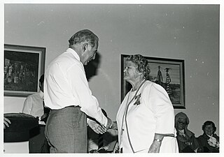
Eileen Marjory Fitzer was an Australian nursing sister, political activist and NT pioneer.

References

  1. 1 2 3 Australian Bureau of Statistics (28 June 2022). "Timber Creek (All Persons)". 2021 Census QuickStats. Retrieved 15 July 2022. OOjs UI icon edit-ltr-progressive.svg
  2. "Traditional owners win Timber Creek claim". ABC News. 17 July 2006. Retrieved 12 February 2024.
  3. "The Timber Creek compensation case". ANTAR. 12 December 2023. Retrieved 12 February 2024.
  4. 1 2 FAHCSIA Timber Creek Land Claim, Report no. 21, 1985 [ dead link ]
  5. 1 2 3 Hilly, Laura (Summer 2018). "Navigating two systems of thought and law: The first sitting of the High Court in Darwin" (PDF). Victorian Bar News (164): 56–57.
  6. "Travelling Australia information website". Archived from the original on 7 March 2016.
  7. 1 2 3 "Place Names Register Extract: Timber Creek". Place Names Register. Retrieved 12 February 2024.
  8. "Timber Creek & Victoria River". Katherine Town Council . Retrieved 10 May 2012.
  9. "Gregory's Tree". Monument Australia. Retrieved 12 October 2022.
  10. 1 2 "Gregory's Tree, Timber Creek". Visit the Northern Territory, Australia. Retrieved 12 October 2022.
  11. "About Timber Creek". Timber Creek Hotel / Fogarty's Store / Circle F Caravan Park. Retrieved 10 May 2012.
  12. Australia at War 2/1 NORTH AUSTRALIA OBSERVER UNIT (2/1 NAOU) THE "NACKEROOS"
  13. Victoria Daly Shire Council Timber Creek Timber Creek Archived 10 April 2012 at the Wayback Machine
  14. Ord River Irrigation Scheme Archived 16 October 2011 at the Wayback Machine
  15. NRETAS Document regarding Victoria Highway Upgrades Archived 29 March 2012 at the Wayback Machine , Northern Territory Government, 2003
  16. Steelcon Constructions NT Bradshaw Bridge Archived 10 April 2013 at the Wayback Machine
  17. 1 2 Australian Human Rights Commission (2008). "Chapter 3: Selected native title cases: 2007-08". Native Title Report 2008 . Retrieved 12 February 2024.
  18. 1 2 "High Court comes to Darwin: Valuing native title in dollars". Northern Land Council . 21 December 2018. Retrieved 12 February 2024.
  19. Hobbs, Harry (4 November 2022). "The Timber Creek Decision". ANTAR. Retrieved 12 February 2024. PDF
  20. Spina-Matthews, Sarah (9 January 2023). "Remote NT communities remain cut off by floodwaters as Timber Creek region mayor calls for new evacuation plan". ABC News. Australian Broadcasting Corporation . Retrieved 12 January 2023.
  21. "Summary Statistics for Timber Creek". Australian Bureau of Meteorology.
  22. 1 2 "Timber Creek, NT". Aussie Towns. 16 March 2021. Retrieved 11 February 2024.
  23. NRETAS Judburra/Gregory National Park Archived 25 March 2012 at the Wayback Machine , Northern Territory Government
  24. NRETAS Judburra/Gregory National Park Fact Sheet Archived 28 March 2012 at the Wayback Machine , Northern Territory Government
  25. Parks and Wildlife Service of the Northern Territory (June 2011), Judbarra / Gregory National Park and Gregory's Tree Historical Reserve Joint Management Plan (PDF), Northern Territory Department of Natural Resources, Environment, The Arts and Sport, p. 36, archived from the original (PDF) on 27 March 2012
  26. "Timber Creek". Visit the Northern Territory, Australia. Retrieved 11 February 2024.
  27. National Trust Northern Territory, Timber Creek Old Police Station Precinct Archived 9 September 2012 at archive.today
  28. "Timber Creek". Victoria Daly Regional Council . 1 November 2023. Retrieved 11 February 2024.
  29. Ngaliwurru-Wuli Aboriginal Corporation (February 2019). "Ngaliwurru-Wuli Aboriginal Corporation" (PDF).
  30. "Ngaliwurru-Wuli Association Mechanical Workshop". truelocal.com.au. Retrieved 11 February 2024.
  31. Powercorp Automated Power Stations Commission Period 2005-2004 [ dead link ]
  32. "Timber Creek School". NT Government Education Directory. Retrieved 11 February 2024.
  33. "Timber Creek". Katherine West Health Board. Retrieved 11 February 2024.
  34. "Home". Timber Creek Hotel and Caravan Park. Archived from the original on 17 August 2017.
  35. "About". Timber Creek Travellers Rest. 26 May 2023. Retrieved 11 February 2024.
  36. "Home". Timber Creek Travellers Rest. 26 May 2023. Retrieved 11 February 2024.
  37. "About Us". Wirib. 24 October 2022. Retrieved 11 February 2024.
  38. "Greyhound Service Timetable for: Broome > Darwin" (PDF). Greyhound Australia. 26 October 2023.
  39. "Greyhound Service Timetable for: Darwin > Broome" (PDF). Greyhound Australia. 26 October 2023.
  40. "Bradshaw Defence Area, Timber Creek, NT, Australia (Place ID 102921)". Australian Heritage Database . Australian Government . Retrieved 12 February 2024.
  41. 1 2 3 O'Brien, Kristy (6 February 2024). "The unlikely alliance between defence forces and traditional owners transforming Timber Creek". ABC News (Australia) . Retrieved 12 February 2024.
  42. "Bradshaw Traditional Owners welcome troops". Northern Land Council . 24 September 2021. Retrieved 12 February 2024.