
The Northern Territory is an Australian territory in the central and central northern regions of Australia. The Northern Territory shares its borders with Western Australia to the west, South Australia to the south, and Queensland to the east. To the north, the territory looks out to the Timor Sea, the Arafura Sea and the Gulf of Carpentaria, including Western New Guinea and other islands of the Indonesian archipelago.

Katherine is a town in the Northern Territory of Australia. It is situated on the Katherine River, after which it is named, 320 kilometres (200 mi) southeast of Darwin. It is the fourth largest settlement in the Territory and is known as the place where "The outback meets the tropics". Katherine had an urban population of approximately 6,300 at the 2016 Census.

St George is a rural town and locality in the Shire of Balonne, Queensland, Australia. It is the administrative centre for the Shire of Balonne. In the 2021 census, St George had a population of 3,130 people.
Wadeye is a town in Australia's Northern Territory. It was formerly known as Port Keats. At the 2016 census, Wadeye had a population of 2,280. Wadeye is the 6th most populous town, and the largest Indigenous community in the Northern Territory.

Kalkarindji is a town and locality in the Northern Territory of Australia, located on the Buntine Highway about 554 kilometres (344 mi) south of the territory capital of Darwin and located about 460 kilometres (290 mi) south of the municipal seat in Katherine.

In Australia and New Zealand, a cattle station is a large farm, the main activity of which is the rearing of cattle. The owner of a cattle station is called a grazier. The largest cattle station in the world is Anna Creek Station in South Australia, which covers an area of 23,677 square kilometres.

Harts Range, officially registered as Hart Range, is a town in the Northern Territory of Australia located on the Plenty Highway 215 km (134 mi) by road northeast of Alice Springs. It is also the name of a mountain range, after which it was named. It has also been referred to as Hart's Range. The Plenty River runs to the north of the range and the town.

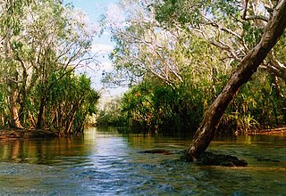
Daly River is a town adjacent to the Daly River in the Northern Territory of Australia. At the 2006 census, Daly River had a population of 468. The town is part of the Victoria Daly Region local government area. The area is popular for recreational fishing, being regarded as one of the best places to catch Barramundi in Australia.
Nemarluk was an Aboriginal warrior who lived around present-day Darwin in the Northern Territory of Australia. He fought strongly against both white and Japanese intruders who had come, into his people's tribal lands.
The Gurindji are an Aboriginal Australian people of northern Australia, 460 kilometres (290 mi) southwest of Katherine in the Northern Territory's Victoria River region.
Peppimenarti is an Aboriginal Australian community in the Daly River region of the Northern Territory, Australia. Peppimenarti is situated on Tom Turner Creek approximately 320 kilometres (200 mi) south-west of Darwin. The population in the 2016 Census was 178.
Timber Creek, traditionally known as Makalamayi, is an isolated small town on the banks of the Victoria River in the Northern Territory of Australia. The Victoria Highway passes through the town, which is the only significant settlement between the Western Australia border and the town of Katherine to the east. Timber Creek is approximately 600 kilometres (370 mi) south of Darwin, in an area known for its scenic escarpments and boab trees.
Daguragu, previously also known as Wattie Creek by the Gurindji people as it is situated on a tributary of the Victoria River, is a locality in the Northern Territory of Australia. It is located about 551 kilometres (342 mi) south of the territory capital of Darwin and located about 460 kilometres (290 mi) south-west of the municipal seat in Katherine. It is around 8 km (5.0 mi) north-west of Kalkarindji. Daguragu community is situated on Aboriginal land held under perpetual title; it was also formerly a local government area until its amalgamation into the Victoria Daly Shire on 1 July 2008.

The Daly River Road is a designated state route in the Northern Territory of Australia providing access to the settlements of Daly River (Nauiyu), Peppimenarti and Wadeye. The road was upgraded and sealed between Dorat Road and Daly River, skirting the southern boundary of Litchfield National Park in late 2007 to allow better access for an increasing volume of tourist traffic heading into the region, known for good fishing during the dry season. The remaining distance between the Daly River crossing and Wadeye remains unsealed and suitable for four-wheel drive vehicles depending on weather conditions.
Victoria River Downs Station, also known as Victoria Downs and in the past sometimes referred to as The Big Run, is a pastoral lease that operates as a cattle station in the Northern Territory of Australia, established in 1883.
The Goyder River is a river in the Northern Territory of Australia.
The Mati Ke, also known as the Magatige, are an Aboriginal Australian people, whose traditional lands are located in the Wadeye area in the Northern Territory. Their language is in danger of extinction, but there is a language revival project under way to preserve it.

The West Daly Regional Council is a local government area of the Northern Territory, Australia. The shire covers an area of 14,070 square kilometres (5,430 sq mi) and had a population of 3,649 in June 2018, with over 90% identifying as Aboriginal. During the wet season between late November and early May, travel between the three main communities of Nganmarriyanga, Peppimenarti and Wadeye is limited to air as roads are cut by flooding.
Nemarluk is a locality in the Northern Territory of Australia located about 210 kilometres (130 mi) south-west of the territorial capital of Darwin.
Gurindji is a locality in the Northern Territory of Australia located about 459 kilometres (285 mi) south of the territory capital of Darwin.
