Andrew Barton "Banjo" Paterson, was an Australian bush poet, journalist and author, widely considered one of the greatest writers of Australia's colonial period.

Dubbo is a city in the Orana Region of New South Wales, Australia. It is the largest population centre in the Orana region, with a population of 43,516 at June 2021.

Orange is a city in the Central Tablelands region of New South Wales, Australia. It is 254 km (158 mi) west of the state capital, Sydney [206 km (128 mi) on a great circle], at an altitude of 862 metres (2,828 ft). Orange had an urban population of 41,920 at the 2021 Census, making the city a significant regional centre. A significant nearby landmark is Mount Canobolas with a peak elevation of 1,395 m (4,577 ft) AHD and commanding views of the district. Orange is situated within the traditional lands of the Wiradjuri tribe.

Narromine (/næroʊmaɪn/) is a rural Australian town located approximately 40 kilometres (25 mi) west of Dubbo in the Orana region of New South Wales. The town is at the centre of Narromine Shire. The 2021 census recorded a population of 3,507. Narromine holds strong historical ties to the Australian Military, as it was the location of RAAF No.19 Inland Aircraft Fuel Depot (IAFD) during World War II. The base contributed to the preparation of troops through a training organisation known as the Empire Air Training Scheme (EATS). The town was one of twelve locations for the No.5 Elementary Flying Training School RAAF in 1940.

Wellington is a town in the Central Western Slopes region of New South Wales, Australia, located at the junction of the Wambuul Macquarie and Bell Rivers. It is within the local government area of Dubbo Regional Council. The town is 362 kilometres (225 mi) northwest of Sydney on the Mitchell Highway and Main Western Railway, and 50 km southeast of Dubbo, the main centre of the Central Western Slopes region.

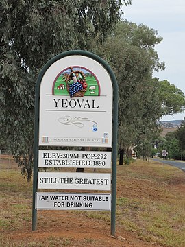
Molong is a small town in the Central West region of New South Wales, Australia, in Cabonne Shire.
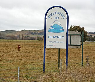
Blayney is a farming town and administrative centre with a population of 2,997 in 2021, in the Central West region of New South Wales, Australia. Situated on the Mid-Western Highway about 240 km (150 mi) west of Sydney, 35 km (22 mi) west of Bathurst and 863 m (944 yd) above sea-level, Blayney is the seat of Blayney Shire Council.

Cabonne Council is a local government area in the Central West region of New South Wales, Australia. The Shire is located adjacent to the Mitchell Highway and the Broken Hill railway line, partly surrounding the City of Orange. The administrative centre is located at Molong.

The South Western Slopes, also known as the South West Slopes, is a region predominantly in New South Wales, Australia. It covers the lower inland slopes of the Great Dividing Range, extending from north of Dunedoo through central NSW and into northeast Victoria, meeting its southwestern end around Beechworth. More than 90% of the region is in the state of New South Wales and it occupies about 10% of that state.

Cumnock is a small town in New South Wales, Australia. It is located on the now closed cross-country railway line from Molong to Dubbo. The town is located in Cabonne Shire. At the 2011 census, Cumnock had a population of 275 people. In the 2021 census the "Suburbs and Localities" of Cumnock had a population of 491.

Blayney Shire is a local government area in the Central West region of New South Wales, Australia. The Shire is located adjacent to the Mid-Western Highway and the Main Western railway line, and is centred on the town of Blayney.
The City of Orange is a local government area in the Central West region of New South Wales, Australia. Based in Orange, the area is located adjacent to the Mitchell Highway and the Main Western railway line.
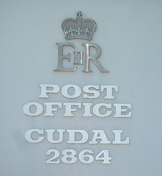
Cudal is a town in the Central West region of New South Wales, Australia, on the traditional lands of the Wiradjuri people. Cudal is in the Cabonne Shire Council local government area, 296 kilometres (184 mi) west of the state capital, Sydney. The town was first surveyed in 1867. Running through the town is "Boree Creek". Platypodes are common in the Boree Creek, giving Cudal the catchline 'home of the platypus' on signs entering the town. The place name, Cudal, could have derived from an Aboriginal word meaning 'flat'. At the 2011 census, Cudal had a population of 339. Industry and commerce in Cudal is a mixture of retail, government services, and agriculture. Cudal is surrounded by fertile basalt soils, the result of lava flows from Gaanha Bula Mount Canobolas, 30 kilometres to the east.
Yullundry is a rural locality between the towns of Yeoval and Cumnock in the Central West region of New South Wales, Australia.
North Yeoval is a locality in New South Wales, Australia. It is the part of the village of Yeoval which lies within Dubbo Regional Council. The majority of the Village lies within the Cabonne shire. The dividing line is the Buckinbah Creek. North Yeoval is where the railway station was located as well as where the grain silos and bulk head are positioned. The Yeoval cemetery is also located in North Yeoval.
Drago Marin Cherina is a Croatian sculpting artist, who was naturalized Australian in the years 1970.
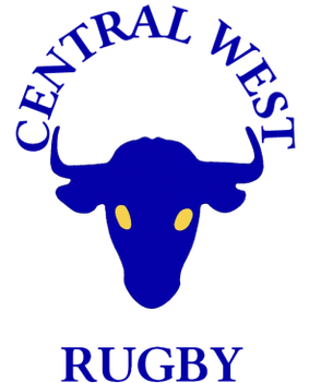
The Central West District Rugby Union, or CWRU, is the governing body for the sport of rugby union within the Central West district of New South Wales in Australia. It is a member of the New South Wales Country Rugby Union.

The Dubbo Regional Council is a local government area located in the Central West and Orana regions of New South Wales, Australia. The council was formed on 12 May 2016 through a merger of the City of Dubbo and Wellington Council as part of a widespread council amalgamation program. It was initially named Western Plains Regional Council for almost four months, and its name was changed to Dubbo Regional Council on 7 September 2016.

Buckinbah Parish is a civil parish of Gordon County, New South Wales, a Cadastral divisions of New South Wales.
Bertha Chatto St. George Smith, also known as Bertha Mac Smith, was an Australian author and philanthropist. She was appointed an Officer of the British Empire in 1964, in recognition of her work as national president of the Country Women's Association of Australia.