Australia's Highway 1 is a network of highways that circumnavigate the country, joining all state capitals except the national capital of Canberra. At a total length of approximately 14,500 km (9,000 mi) it is the longest national highway in the world, surpassing the Trans-Siberian Highway and the Trans-Canada Highway. Over a million people traverse some part of the highway network every day.
Metroads were the primary road routes serving the Sydney and Brisbane metropolitan areas from the 1990s to the early 2010s. The Metroads formed a network of radial and circumferential routes throughout the cities, simplifying navigation. Metroads have been progressively phased out in both Sydney and Brisbane, replaced by alphanumeric route numbers. Brisbane is the only city currently retaining the Metroad system.

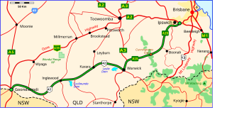
The Warrego Highway is located in southern Queensland, Australia. It connects coastal centres to the south western areas of the state, and is approximately 715 km in length. It takes its name from the Warrego River, which is the endpoint of the highway. The entire highway is part of the National Highway system linking Darwin and Brisbane: formerly National Highway 54, Queensland began to convert to the alphanumeric system much of Australia had adopted in the early-2000s and this road is now designated as National Highway A2.
The Cunningham Highway is a 327-kilometre (203 mi) national highway located in south-eastern Queensland, Australia. The highway links the Darling Downs region with the urbanised outskirts of Ipswich via Cunninghams Gap.
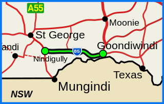
The Barwon Highway is one of the shorter state highways of Queensland, Australia. It starts at the Carnarvon Highway in Nindigully, 44 kilometres south of St George, and travels east for about 155 kilometres until it reaches Goondiwindi, where it terminates at the Leichhardt Highway.

The Brisbane Valley Highway is a state highway in Queensland. It links the Warrego Highway near Ipswich and the D'Aguilar Highway about 4 km (2 mi) north of Harlin. Its direction follows the approximate course of the Brisbane River. It is part of State Route A17, which is duplexed with the D'Aguilar Highway to Nanango and then becomes the Burnett Highway. State Route 85 is duplexed with the Brisbane Valley Highway from Esk to the D'Aguilar Highway.

The Gore Highway is a highway running between Toowoomba and Goondiwindi in Queensland, Australia. Together with Goulburn Valley Highway and Newell Highway, it is a part of the National Highway's Melbourne-Brisbane link. It is signed as National Highway A39.

The M2/M6 Logan Motorway is a 30-kilometre toll road between Ipswich and the M1 or Pacific Motorway at Loganholme, and the Gateway Motorway, providing access to the Gold Coast on the eastern seaboard and to the rural areas of the Darling Downs to the west. The M6 portion runs from the Pacific Motorway to the junction with the Gateway Motorway at Drewvale, where it then becomes the M2, continuing on to merge with the Ipswich Motorway at Gailes.

The Ipswich Motorway (M7) is a major road that connects Brisbane and Ipswich in South East Queensland, Australia. It commences at the junction of Ipswich Road and Granard Road and proceeds through to the M2 Logan Motorway interchange. It is then signed M2 until the junction of the Warrego Highway and the Cunningham Highway
This is a list of current and former electoral divisions for the Legislative Assembly of Queensland, the state legislature for Queensland, Australia.
The Dawson River is a river located in Central Queensland, Australia.
The (M2) in Brisbane, Queensland, Australia, is a major motorway route and southern bypass of Brisbane. It connects the Warrego Highway (A2) at Brassall to the (M1) at Eight Mile Plains via the following corridors:

The road transport of Brisbane, Australia consists of a network of highways, freeways and motorways. Some motorways have tolls applied.
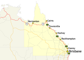
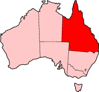
In Queensland, Highway 1 is a 2,964-kilometre (1,842 mi) long route that crosses the state, from the Northern Territory (NT) border near Wollogorang to Cairns, and then travels along the coastline to the New South Wales (NSW) border near Coolangatta. Highway 1 continues around the rest of Australia, joining all mainland state capitals, and connecting major centres in Tasmania. All roads within the Highway 1 system are allocated a road route numbered 1, M1, A1, or B1, depending on the state route numbering system. In Queensland, the highway is designated as National Route 1 from the NT border to Cairns, Route A1 from Cairns to Kybong, and then Route M1 down to the NSW border.
The Adventure Way is an Australian outback route between Brisbane, Queensland and Innamincka, South Australia. Using the Adventure Way, it is 1,152 kilometres (716 mi) from Brisbane to Innamincka. The recommended journey time, allowing for some sightseeing, food and rest is 96 hours. It has been designated by the Queensland Government as a State Strategic Touring Route.
The Great Inland Way is an Australian road route from Sydney, New South Wales to Cairns in Queensland. It has been designated by the Queensland Government as a State Strategic Touring Route.
The Matilda Way is an Australian road route from Bourke, New South Wales to Karumba in Queensland. It has been designated by the Queensland Government as a State Strategic Touring Route.
The Pacific Coast Way is an Australian road route from Sydney, New South Wales to Cairns in Queensland. It has been designated by the Queensland Government as a State Strategic Touring Route.

The Toowoomba Connection Road is a 27.3 km (17.0 mi) former section of the Warrego Highway that passes through the city of Toowoomba in Queensland, Australia. With the opening of the Toowoomba Bypass in 2019 the Warrego Highway was redirected to it, and the bypassed section of the highway was renamed Toowoomba Connection Road and assigned the route number A21.